MyTopo
Boise South Idaho US Topo Map
Couldn't load pickup availability
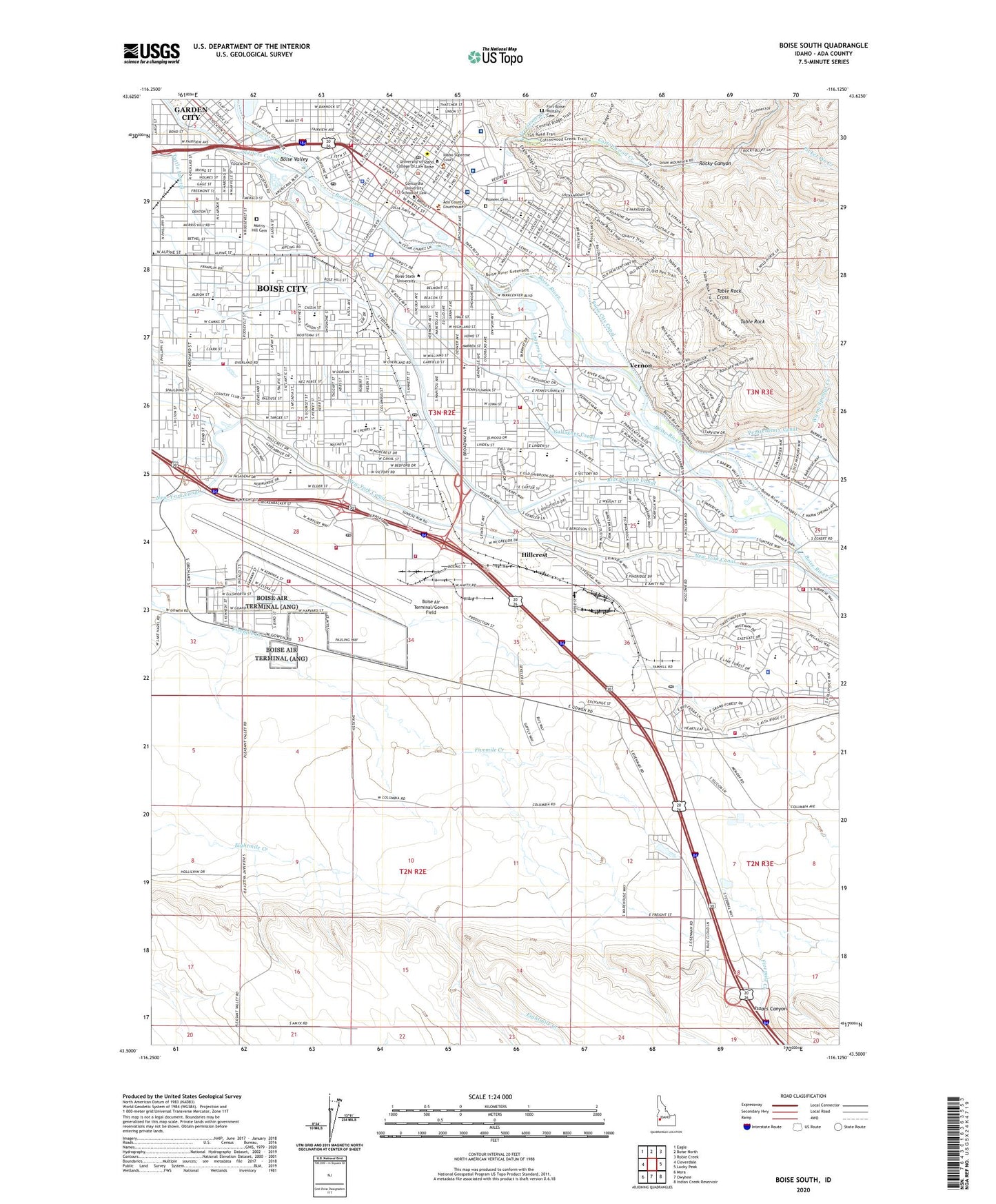
2024 topographic map quadrangle Boise South in the state of Idaho. Scale: 1:24000. Based on the newly updated USGS 7.5' US Topo map series, this map is in the following counties: Ada. The map contains contour data, water features, and other items you are used to seeing on USGS maps, but also has updated roads and other features. This is the next generation of topographic maps. Printed on high-quality waterproof paper with UV fade-resistant inks.
Quads adjacent to this one:
West: Cloverdale
Northwest: Eagle
North: Boise North
Northeast: Robie Creek
East: Lucky Peak
Southeast: Indian Creek Reservoir
South: Owyhee
Southwest: Mora
This map covers the same area as the classic USGS quad with code o43116e2.
Contains the following named places: Ada County Paramedics Medical Station 53, Ada County Paramedics Medical Station 58, Ada County Paramedics Medical Station 68, Adams Elementary School, Aldape Park, Ann Morrison Park, Ayres Park, Barber, Bennett Lateral, Boise, Boise Air Terminal Air Guard Station, Boise Air Terminal/Gowen Field, Boise Airport Station Post Office, Boise Christian School, Boise City Canal, Boise City Fire Department Station 1, Boise City Fire Department Station 12 Region 4 Hazardous Materials Team, Boise City Fire Department Station 22, Boise City Fire Department Station 3, Boise City Fire Department Station 5, Boise City Fire Department Station 7, Boise City Fire Department Station 8, Boise Mounted Patrol, Boise Police Department, Boise Police Department Boise State University, Boise Post Office, Boise Senior High School, Boise State University, Boise Valley, Boise Veterans Affairs Medical Center, Borah Post Office, Bowden Park, Bubb Canal, Bureau of Land Management Boise District, Bureau of Land Management Bruneau Field Office, Bureau of Land Management Four Rivers Field Office, Carden School of Boise, City of Boise City, Congregation Ahavath Beth Israel Synagogue, Cottonwood Creek, East Junior High School, Fairview Park, Fairview Square, Farmers Lateral, Firehouse #19 Boise Fire Department Aircraft Rescue Fire Fighting Unit, First Security Plaza, Fort Boise Learning Center, Fort Boise Military Cemetery, Fort Boise Park, Franklin Elementary School, Freestone Creek, Gallagher Canal, Garden City, Garfield Elementary School, Good Shepherd Lutheran Preschool and Kindergarten, Hawthorne Elementary School, Hillcrest, Hillcrest Country Club, Hillcrest Elementary School, Hillcrest Plaza, Hyatt Lateral, Idaho Air National Guard Fire Department, Idaho Elks Rehabilitation Hospital, Idaho Mountain Rescue Unit, Idaho State Capitol, Idaho State Penitentiary Cemetery, Isaacs Canyon, Ivywild Park, Jefferson Elementary School, Julia Davis Park, Liberty Elementary School, Lincoln School, Loggers Creek, Monroe Elementary School, Morris Hill Cemetery, Noble Park, Old Boise Plaza, Oregon Trail Post Office, Overland Post Office, Owyhee Elementary School, Penninger Lateral, Picket Pin Creek, Pioneer Cemetery, Prickett School, Riverside Elementary School, Rocky Canyon, Roosevelt Elementary School, Sacred Heart School, Saint Joseph's Catholic School, Saint Luke's Boise Medical Center, Saint Lukes Heliport, Saint Lukes Hospital, South Boise, South Junior High School, Table Rock, Table Rock Cross, The Children's School of Boise, The Elementary Montessori School, Thomson Lateral, Tillotson Lateral, Vernon, Vista Village Shopping Center, Warm Springs Creek, White Pine Elementary School, Whitney Elementary School, Whittier Elementary School, ZIP Codes: 83705, 83706