MyTopo
Eagle Idaho US Topo Map
Couldn't load pickup availability
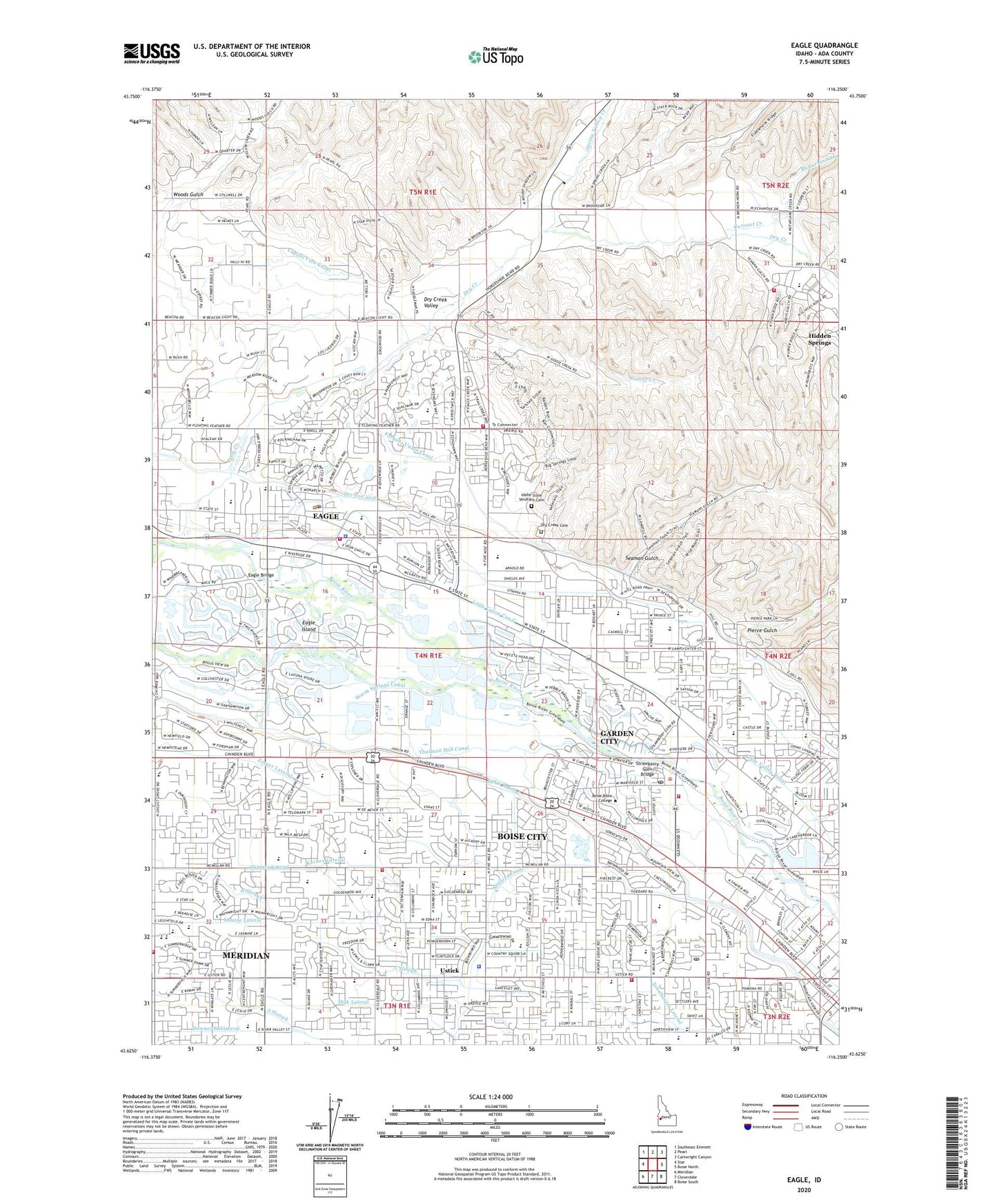
2024 topographic map quadrangle Eagle in the state of Idaho. Scale: 1:24000. Based on the newly updated USGS 7.5' US Topo map series, this map is in the following counties: Ada. The map contains contour data, water features, and other items you are used to seeing on USGS maps, but also has updated roads and other features. This is the next generation of topographic maps. Printed on high-quality waterproof paper with UV fade-resistant inks.
Quads adjacent to this one:
West: Star
Northwest: Southeast Emmett
North: Pearl
Northeast: Cartwright Canyon
East: Boise North
Southeast: Boise South
South: Cloverdale
Southwest: Meridian
This map covers the same area as the classic USGS quad with code o43116f3.
Contains the following named places: Ada County Paramedics Medical Station 56, Ada County Paramedics Medical Station 59, Ada County Paramedics Medical Station 60, Ada County Sheriff's Office Eagle, Ballentine Canal, Boise City Fire Department Station 10, Boise City Fire Department Station 4, Boise Police Department, Boise Valley Canal, Bradley Field, Bresheres Lateral, Capital High School, Capitol View Canal, Centennial High School, City of Garden City, Cole Valley Elementary Campus, Cole Village Post Office, Currant Creek, Cynthia Mann Elementary School, Downey Sublateral, Dry Creek, Dry Creek Canal, Dry Creek Cemetery, Dry Creek Valley, Eagle, Eagle Bridge, Eagle Elementary School of the Arts, Eagle Fire Protection District Station 1, Eagle Fire Protection District Station 2, Eagle Hills Elementary School, Eagle Post Office, Echelberger Lateral, Floating Feather Airport, Frontier Elementary School, Garden City Post Office, Gateway School of Language and Culture, Glider Airport, Goose Creek, Green Meadows School, Helm Lateral, Hidden Springs Census Designated Place, Idaho State Veterans Cemetery, Joplin Cemetery, Joplin Elementary School, Karnes Lateral, Lake Elmore, Little Union Canal, Lowell Scott Middle School, Mason-Catlin Canal, McFarland Creek, McMillan Chapel, Meridian Fire Department Station 3, Milk Lateral, Mountain View Elementary School, North Ada County Fire and Rescue Station 1, North Ada County Fire and Rescue Station 3, Northgate Shopping Center, Northview Hospital, Nourse Lateral, Pierce Gulch, Pierce Park Elementary School, Pioneer School of the Arts, Seaman Gulch, Shavrer Lateral, Snyder Lateral, Spring Valley Creek, Strawberry Glen Airport, Strawberry Glen Bridge, Summerwind STEM Academy, Thurman Mill, Thurman Mill Canal, Ustick, Ustick Elementary School, Valley View Elementary School, Valley View School, Warm Springs Canal, Western Idaho Fairgrounds, White Cross School, Winstead Park, Woods Gulch, Zinger Lateral, ZIP Codes: 83704, 83713, 83714