MyTopo
Rend Lake Dam Illinois US Topo Map
Couldn't load pickup availability
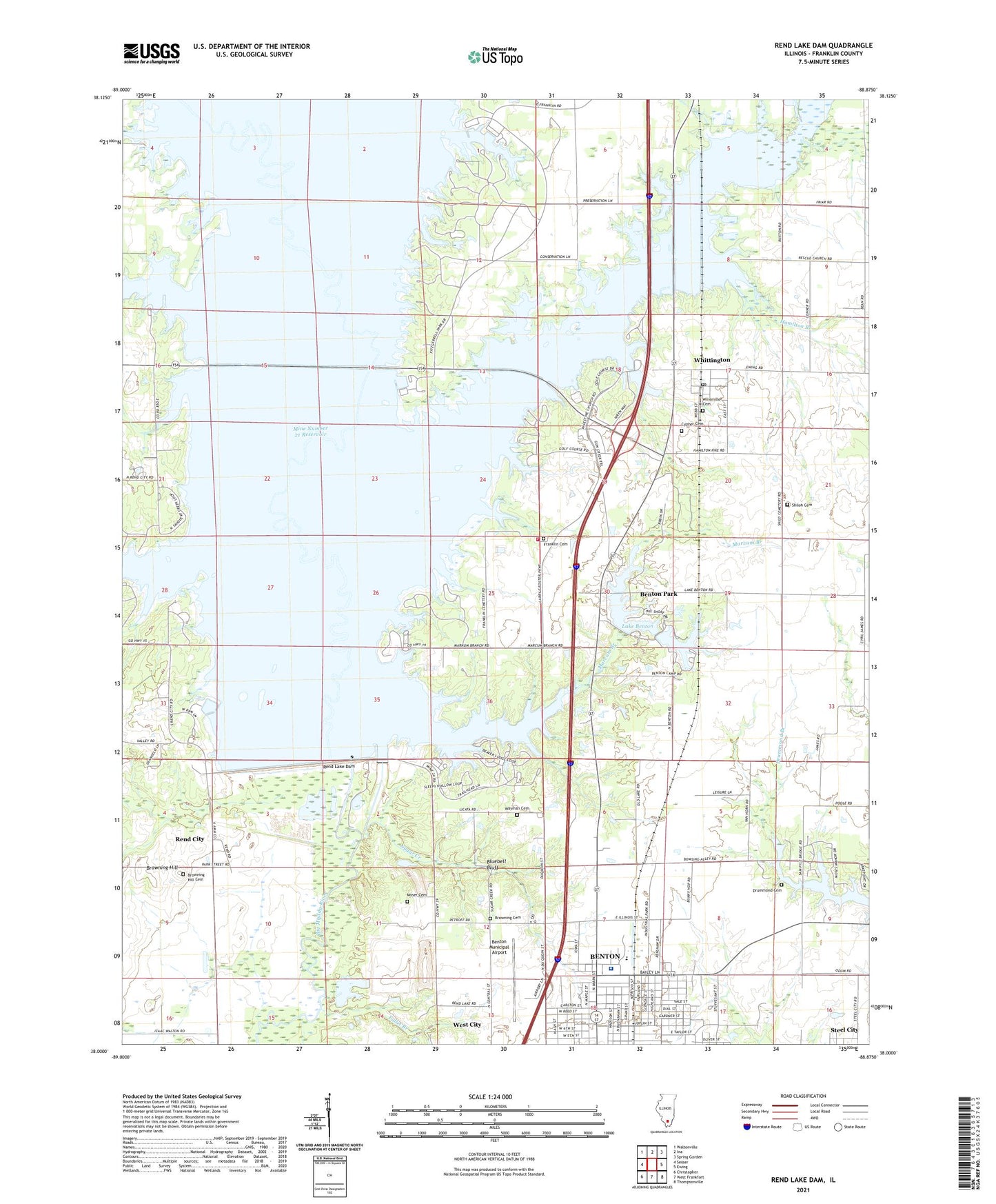
2024 topographic map quadrangle Rend Lake Dam in the state of Illinois. Scale: 1:24000. Based on the newly updated USGS 7.5' US Topo map series, this map is in the following counties: Franklin, Jefferson. The map contains contour data, water features, and other items you are used to seeing on USGS maps, but also has updated roads and other features. This is the next generation of topographic maps. Printed on high-quality waterproof paper with UV fade-resistant inks.
Quads adjacent to this one:
West: Sesser
Northwest: Waltonville
North: Ina
Northeast: Spring Garden
East: Ewing
Southeast: Thompsonville
South: West Frankfort
Southwest: Christopher
This map covers the same area as the classic USGS quad with code o38088a8.
Contains the following named places: Airport Industrial Park, Barren Townhall, Benton Country Club, Benton Lookout Tower, Benton Municipal Airport, Benton North Oil Field, Benton Park, Bluebell Bluff, Browning Cemetery, Browning Hill, Browning Hill Cemetery, Casey Fork, Church of God, City of Benton, Conner College, Cypher Cemetery, Drummond Cemetery, Fallet Branch, First Free Will Baptist Church, Flatts School, Franklin Cemetery, Franklin County Fairground, Franklin Hospital, Grant Elementary School, Gun Creek, Gun Creek Public Use Area, Hamilton Branch, Hazel Dell Free Will Baptist Church, Hazel Dell School, Immanuel Baptist Church, Jackie Branch, King College, Lake Benton, Lake Benton Camp, Lake Benton Dam, Lake Hamilton, Lake Hamilton Dam, Lincoln School, Marcum Branch, Marcum Branch North Public Use Area, Marcum Branch South Public Use Area, McGuire School, Mercy Regional Health System, Meyers School, Mine Number 21 Reservoir, Moore Hospital, Moser Cemetery, North Benton Missionary Baptist Church, Old Ben Number 24 Mine, Palestine Church, Palestine School, Rend City, Rend Lake, Rend Lake Conservancy District Heliport, Rend Lake Dam, Rend Lake Dam West Public Use Area, Rend Lake Marina, Rescue Church, Rollinson School, Salem Church, Sandusky Creek, Sandusky Creek North Public Use Area, Sandusky Creek South Public Use Area, Sesser Fire Protection District Station 2, Sesser Public Use Area, Shiloh Cemetery, Shiloh Church, Shiloh School, Spillway Public Use Area, Sugar Creek, Township of Barren, Wayman Cemetery, Wayne Fitzgerrell State Park, Westminister Presbyterian Church, Whispering Pines Group Camp, Whittington, Whittington Oil Field, Whittington Post Office, Winemiller Cemetery, ZIP Code: 62897