MyTopo
West Frankfort Illinois US Topo Map
Couldn't load pickup availability
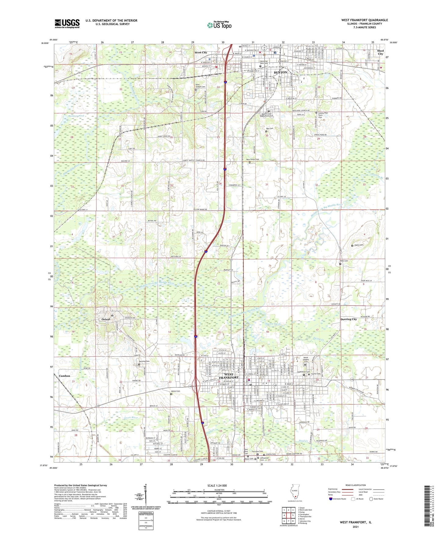
2024 topographic map quadrangle West Frankfort in the state of Illinois. Scale: 1:24000. Based on the newly updated USGS 7.5' US Topo map series, this map is in the following counties: Franklin. The map contains contour data, water features, and other items you are used to seeing on USGS maps, but also has updated roads and other features. This is the next generation of topographic maps. Printed on high-quality waterproof paper with UV fade-resistant inks.
Quads adjacent to this one:
West: Christopher
Northwest: Sesser
North: Rend Lake Dam
Northeast: Ewing
East: Thompsonville
Southeast: Pittsburg
South: Johnston City
Southwest: Herrin
This map covers the same area as the classic USGS quad with code o37088h8.
Contains the following named places: Andy Creek, Apostolic Faith Assembly Church, Assembly of God Church, Barnes School, Benton, Benton Ambulance Service, Benton Christian Church, Benton City Park, Benton Civic Center, Benton Consolidated High School, Benton Fire Department, Benton Middle School, Benton Oil Field, Benton Police Department, Benton Post Office, Benton Public Library, Benton Township Gymnasium, Bethel Church, Boner Cemetery, Boner Chapel, Buckner Pond, Caldwell Church, Calvary Southern Baptist Church, Cambon, Central Junior High School, Central United Methodist Church, Church of Christ, Church of God, City of Orient, City of West Frankfort, Clam School, Community Church, Coon Ridge School, County Cemetery, County Poor Farm Cemetery, Deering City, Denning Cemetery, Denning Elementary School, Denning School, Douglas Public School, Eakin Grove Church, East Benton Baptist Church, Edwards School, Ewing - Northern Fire Protection District Station 3, Ewing Creek, Fairview Cemetery, First Apostolic Church, First Baptist Church, First Baptist Church of Benton, First Christian Church, First Church of Christ Scientist, First Church of God, First Church of the Nazarene, First Northern Baptist Church, First Presbyterian Church, First United Methodist Church, Forest Church, Frankfort, Frankfort Community Park, Frankfort Elementary School, Frankfort High School, Franklin County, Franklin County Courthouse, Franklin County Jail, Franklin County Sheriff's Office, Franklin School, Gatling Branch, Glad Tidings Church, Green River, Hanes Cemetery, Harmony Free Baptist Church, Heights Church of God, Hill City School, Joiner School, Joplin Cemetery, Kingdom Hall of Jehovahs Witnesses, Lincoln School, Lithuanian Cemetery, Logan Public School, Logan School, Masonic and Oddfellows Cemetery, Memorial Park Cemetery, Miners Memorial Health Center, Moore School, Mount Olive Church, Neal Cemetery, New Hope Church, New Union Cemetery, Oddfellow Cemetery, Orient, Pershing, Rea Cemetery, Rend Lake Plaza Shopping Center, Saint Johns Cemetery, Saint Johns Roman Catholic Church, Saint Johns School, Saint Joseph Catholic Church, Saint Joseph Cemetery, Saint Marks Episcopal Church, Saint Pauls Lutheran Church, Second Baptist Church, Steel City, Third Baptist Church, Tower Heights Cemetery, Townmount Church, Township of Browning, Township of Denning, Trinity Baptist Church, Trinity Cemetery, Trinity United Methodist Church, United Jewish Community Center, Village of West City, Washington School, Webster School, Wesleyan Church, West City, West City Fire Department, West City First Baptist Church, West City Police Department, West Frankfort, West Frankfort City Hall, West Frankfort Fire Department, West Frankfort Oil Field, West Frankfort Police Department, West Frankfort Post Office, West Frankfort Public Library, West Frankfort South Oil Field, West Frankfort Water Works, WFRX-AM (West Frankfort), WFRX-FM (West Frankfort), WQRL-FM (Benton), WUEZ-FM (Christopher), ZIP Codes: 62812, 62874, 62896