MyTopo
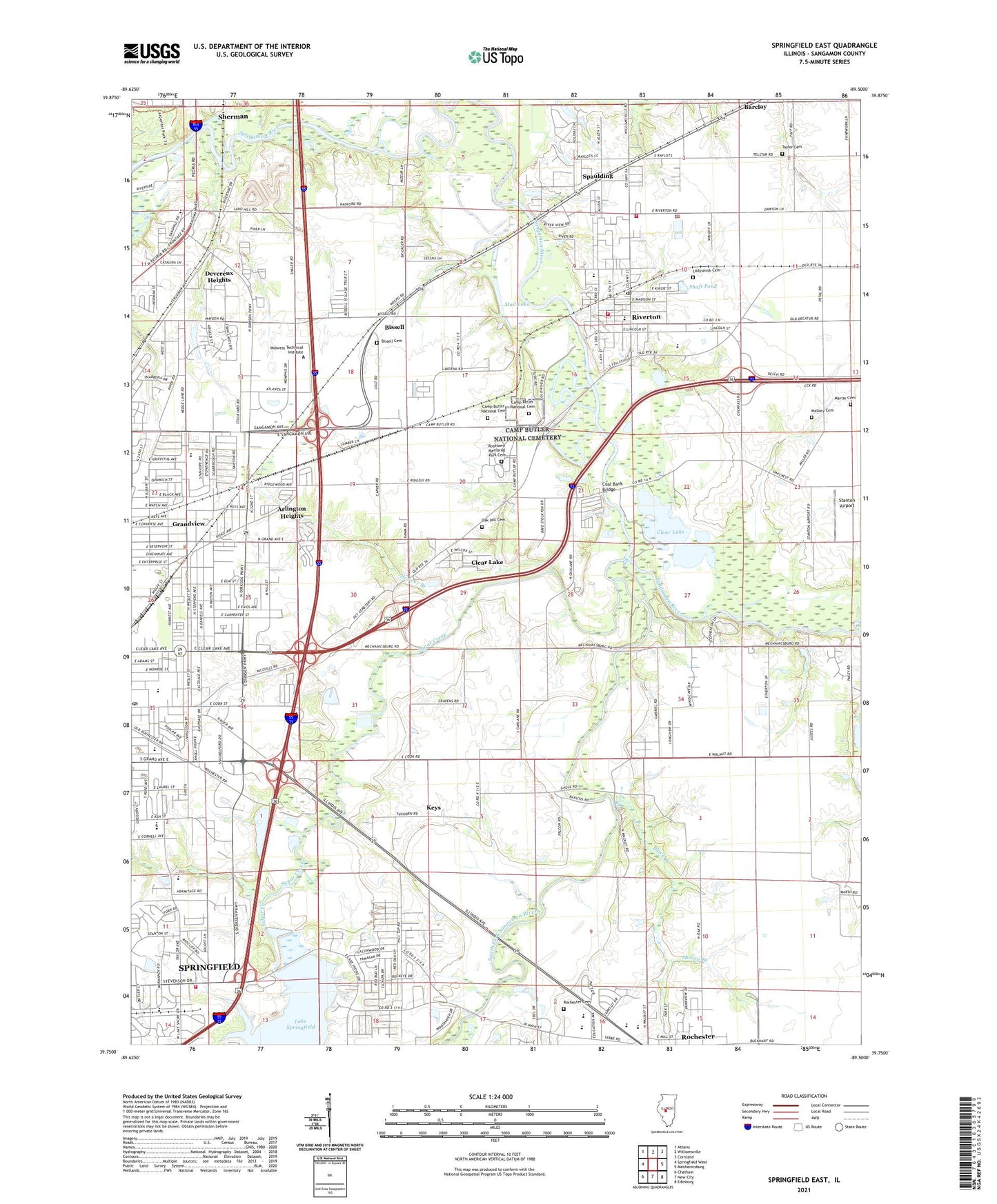
Springfield East Illinois US Topo Map
Couldn't load pickup availability
2024 topographic map quadrangle Springfield East in the state of Illinois. Scale: 1:24000. Based on the newly updated USGS 7.5' US Topo map series, this map is in the following counties: Sangamon. The map contains contour data, water features, and other items you are used to seeing on USGS maps, but also has updated roads and other features. This is the next generation of topographic maps. Printed on high-quality waterproof paper with UV fade-resistant inks.
Quads adjacent to this one:
West: Springfield West
Northwest: Athens
North: Williamsville
Northeast: Cornland
East: Mechanicsburg
Southeast: Edinburg
South: New City
Southwest: Chatham
This map covers the same area as the classic USGS quad with code o39089g5.
Contains the following named places: Arlington Heights, Barclay, Bergen Park, Bissell, Bissell Cemetery, Black Branch, Bluff School, Camp Butler National Cemetery, Capital City Shopping Center, Carpenter Park, Clear Lake, Clear Lake Pit, Clear Lake School, Coal Bank Bridge, Derry Farm, Devereux Heights, Fancy Creek, Forest Park, Fork Prairie School, Grandview, Holiday Inn East Heliport, Hoover Branch, Iles School, Illinois Department of Transportation Heliport, Jaycee Park, Keys, Korean United Presbyterian Church, Ladysmith Cemetery, Mallory Cemetery, Martin Cemetery, Matheny Elementary School, McCoy Branch, Mud Lake, North Round Prairie School, Oak Crest Country Club, Oak Hill Cemetery, Oak Hill School, Piper School, Pleasant Hill Elementary School, Poffenberger School, R and S Airport, Riverside Park, Riverton, Riverton Elementary School, Riverton Fire Protection District, Riverton Fire Protection District Station 2, Riverton High School, Riverton Police Department, Riverton Post Office, Rochester Cemetery, Rochester High School, Roselawn Memorial Park Cemetery, Royal Parkway Dodge Heliport, Saint Cabrini School, Saint James School, Saint Johns Sanitarium, Sand Hill School, Sangamon Valley Landfill, Shaft Pond, Shale Bluff, South Fork Sangamon River, South Round Prairie School, Southlawn, Spaulding, Spaulding Dam, Springfield Area Ambulance, Springfield Fire Department Station 2, Springfield Fire Training Division, Springfield Post Office, Springfield Southeast High School, Stanton Airport, Starne, Streadle, Sugar Creek, Taylor Cemetery, Township of Clear Lake, United Brethren Church, Village of Clear Lake, Village of Grandview, Village of Riverton, Village of Rochester, Village of Spaulding, Wanless Elementary School, Washington Middle School, WCFN-TV (Springfield), WDBR-FM (Springfield), Webster Elementary School, Wesley United Methodist Church, Wilcox Elementary School, Withrow Elementary School, WMAY-AM (Springfield), Woodside United Methodist Church, Wright School, WTAX-AM (Springfield), ZIP Codes: 62561, 62712