MyTopo
Albia Iowa US Topo Map
Couldn't load pickup availability
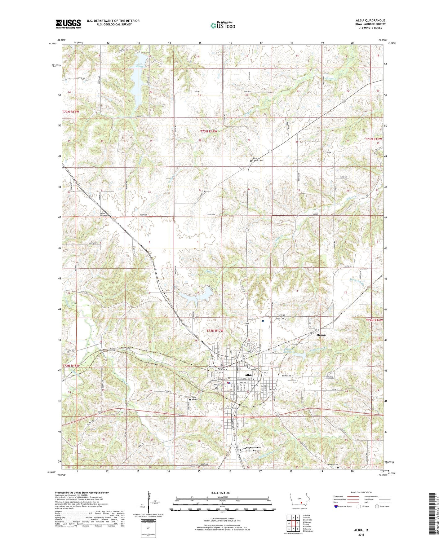
2022 topographic map quadrangle Albia in the state of Iowa. Scale: 1:24000. Based on the newly updated USGS 7.5' US Topo map series, this map is in the following counties: Monroe. The map contains contour data, water features, and other items you are used to seeing on USGS maps, but also has updated roads and other features. This is the next generation of topographic maps. Printed on high-quality waterproof paper with UV fade-resistant inks.
Quads adjacent to this one:
West: Hiteman
Northwest: Lovilia
North: Buxton
Northeast: Eddyville
East: Avery
Southeast: Blakesburg
South: Moravia
Southwest: Iconium
This map covers the same area as the classic USGS quad with code o41092a7.
Contains the following named places: Albia, Albia Baptist Temple, Albia City Hall, Albia Country Club, Albia Fire Department, Albia High School, Albia Holiness Church of God, Albia Junior High School, Albia Post Office, Albia Public Library, Albia Theater, Anderson School, Boggs Cemetery, Brees Rest Home, Cedar Mines, Cedar Mines Post Office, Cedar School, Chiropractic Health Center, Church of Christ, Church of the Open Bible, City of Albia, Coal Creek, Community of Christ Church, Egypt School, Fairview, First Baptist Church, First Christian Church, Fraker, Fraker Post Office, Grace Episcopal Church, Grant Elementary School, Grays Creek School, Hagerty, Halfway Prairie School, Heartland Eye Care Center, Jefferson School, Kendall Elementary School, King School, Kingdom of Jehovahs Witnesses, Lake Miami, Lake Miami Dam, Lincoln Center, Maxon, Maxon Reservoir, Maxon School, Miami Lake State Game Management Area, Monroe Care Center, Monroe City Park, Monroe County, Monroe County Comservation Area, Monroe County Courthouse, Monroe County Fairground, Monroe County Historical Museum, Monroe County Hospital, Monroe County Professional Clinic, Monroe County Sheriff's Office, Monroe County Sports Complex, Oakview Cemetery, Oakwood Nursing and Rehabilitation Center, O'Brien Landing Strip, Pharis School, Pleasant Point School, Reitzel School, Reorganized Church of Jesus Christ of Latter Day Saints, River of Life Family Worship Center, Saint Marys Cemetery, Saint Marys Church, Saint Pauls Lutheran Church, Service Chapel Cemetery, Seventh Day Adventist Church, Spencer School, Tower Station, Township of Bluff Creek, Township of Troy, Trinity United Methodist Church, Union Chapel, Union Chapel Cemetery, Union School, Watson Cemetery, Watson School, Westcastle School, William Crockett Historical Marker, ZIP Code: 52531