MyTopo
Lake Park Iowa US Topo Map
Couldn't load pickup availability
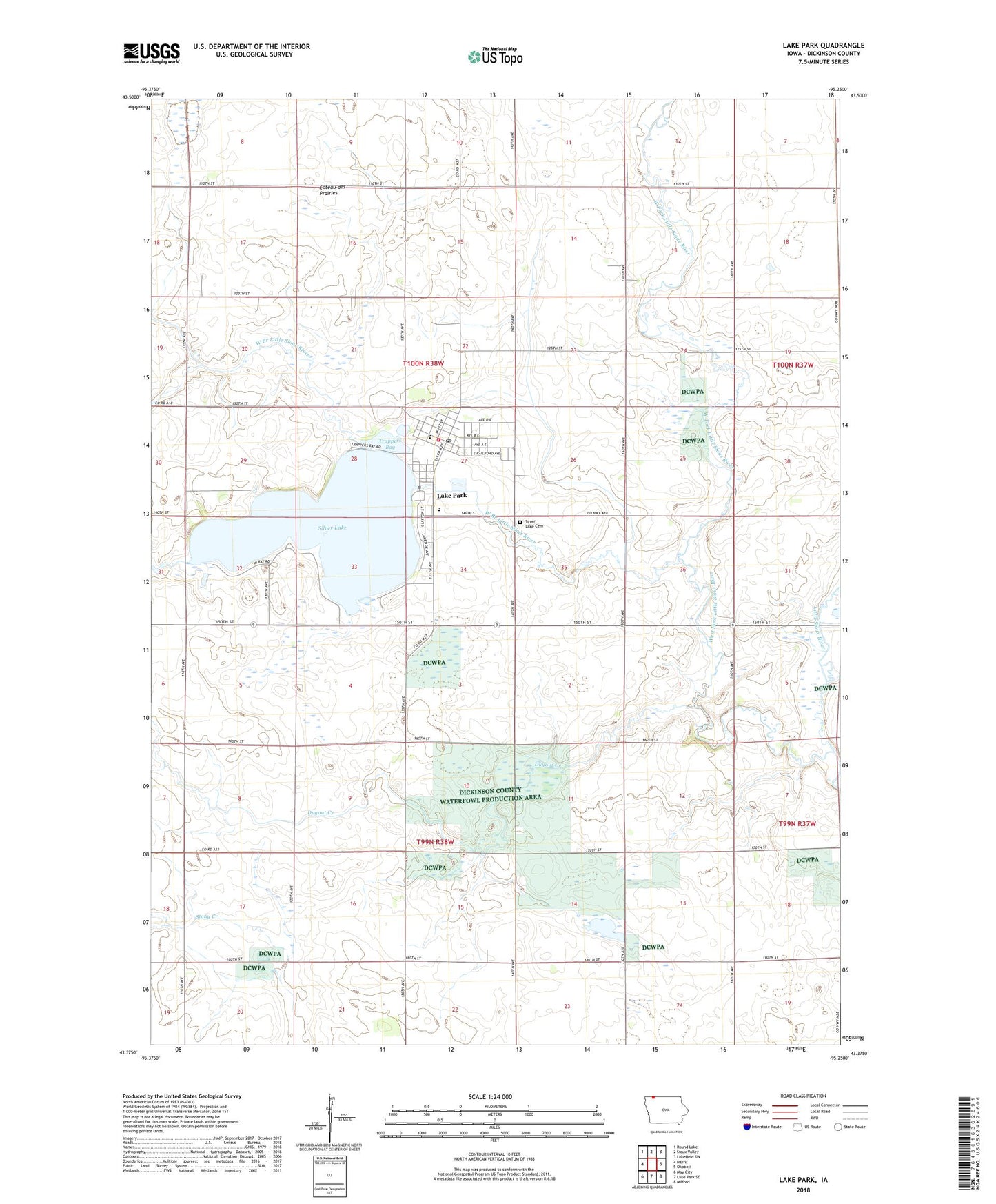
2022 topographic map quadrangle Lake Park in the state of Iowa. Scale: 1:24000. Based on the newly updated USGS 7.5' US Topo map series, this map is in the following counties: Dickinson. The map contains contour data, water features, and other items you are used to seeing on USGS maps, but also has updated roads and other features. This is the next generation of topographic maps. Printed on high-quality waterproof paper with UV fade-resistant inks.
Quads adjacent to this one:
West: Harris
Northwest: Round Lake
North: Sioux Valley
Northeast: Lakefield SW
East: Okoboji
Southeast: Milford
South: Lake Park SE
Southwest: May City
This map covers the same area as the classic USGS quad with code o43095d3.
Contains the following named places: Austin Post Office, City of Lake Park, Concordia Lutheran Church, Cory Marsh State Game Management Area, Dickinson County Waterfowl Production Area, Ditsworth Chiropractic Clinic, Dugout Creek, Dugout Creek Wildlife Management Area, Elser Farms, Excelsior School, Family Dentistry Center, Farmers Exchange Co-op Elevator, First Presbyterian Church, Goodnuff Stock Farms, Harris - Lake Park Elementary School, Harris - Lake Park Middle / High School, Lake Park, Lake Park Care Center, Lake Park Community Health Center, Lake Park Fire Department, Lake Park Post Office, Lake Park Public Library, Lake Park Rescue, Lake Park Water Plant, Long Farms, Silver Lake, Silver Lake Cemetery, Silver Lake Country Club, Silver Lake Fen State Preserve, Silver Lake Wildlife Management Area, T - Bar - K Farm, Township of Excelsior, Township of Silver Lake, Trappers Bay, Trappers Bay State Park, Twin Forks Wildlife Area, United Methodist Church, West Branch Little Sioux River, West Fork Little Sioux River, Yager Slough State Game Management Area, ZIP Code: 51347