MyTopo
Bonner Springs Kansas US Topo Map
Couldn't load pickup availability
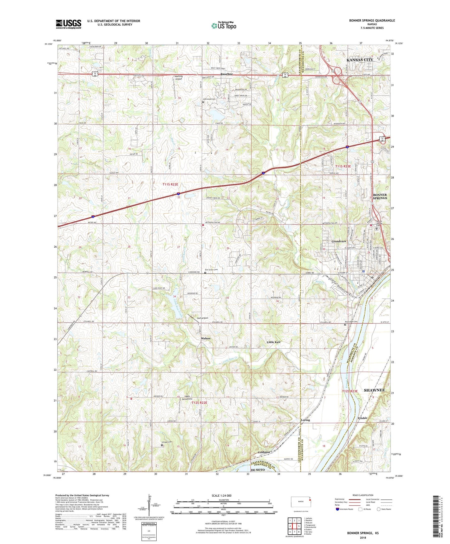
2022 topographic map quadrangle Bonner Springs in the state of Kansas. Scale: 1:24000. Based on the newly updated USGS 7.5' US Topo map series, this map is in the following counties: Leavenworth, Wyandotte, Johnson. The map contains contour data, water features, and other items you are used to seeing on USGS maps, but also has updated roads and other features. This is the next generation of topographic maps. Printed on high-quality waterproof paper with UV fade-resistant inks.
Quads adjacent to this one:
West: Tonganoxie
Northwest: Jarbalo
North: Basehor
Northeast: Wolcott
East: Edwardsville
Southeast: Olathe
South: De Soto
Southwest: Eudora
This map covers the same area as the classic USGS quad with code o39094a8.
Contains the following named places: Basehor - Linwood Middle School, Bible Baptist Church, Bible Baptist School, Bonner Shops, Bonner Springs, Bonner Springs Baptist Church, Bonner Springs Cemetery, Bonner Springs Church of Christ, Bonner Springs City Hall, Bonner Springs City Hall Holding Cell, Bonner Springs City Library, Bonner Springs Community Center, Bonner Springs Elementary School, Bonner Springs Emergency Medical Services, Bonner Springs Estates Mobile Home Park, Bonner Springs Fire Department, Bonner Springs High School, Bonner Springs Police Department, Bonner Springs Post Office, Bonner Springs Unified School District Central Offices, Bonner Springs United Methodist Church, Bonner Springs YMCA, Bovinair Airport, Calvary Bible Church, Capitol Federal Park at Sandstone, Centennial Center, Centers for Long Term Care of Bonner Springs, Church of the Nazarene, City of Bonner Springs, Clark Middle School, Coal Ridge School, Coldspur, Community of Christ Church, Delaware Ridge Elementary School, Elm Grove Cemetery, Elm Grove Community Hall, Elm Grove School, Emmaus Lutheran Church, Fairmount Township Fire Department Station 2, Faith Missionary Baptist Church, First Baptist Church, First Christian Church, First Pentecostal Church, Frisbie, Glenwood, Glenwood Cemetery, Glenwood Ridge Elementary School, Glenwood School, Grace Temple Church of God, Grandview, Hoelting Airport, Huff Airport, Ingels Aerodrome, Jewett School, Kaw Drive Shops, Landmark Baptist Church, Leavenworth County Rural Water District 7 Water Tower, Leavenworth County Sewer District Number 3 Glenwood Estates, Leavenworth County Timberlake Wastewater Treatment Plant, Lenape Cemetery, Little Kaw, Little Kaw Creek, Loring, Loring School, Louisa Fletcher Learning Center - Head Start, Mahon, Maria, McDaniel Education Resource Center, Ne con He con Creek, New Light Baptist Church, Ney Airport, Northridge Centre, Olivet Church of God in Christ, Philo, Rehms Park Southern Baptist Church, Riverview Cemetery, Saint Matthew African Methodist Episcopal Church, Sherman Township Fire Department, Spring Creek, Township of Delaware, Township of Sherman, Twist School, Victory Assembly Church, Walker School, Wolf Creek, Wolf Creek Industrial Park, ZIP Code: 66012