MyTopo
De Soto Kansas US Topo Map
Couldn't load pickup availability
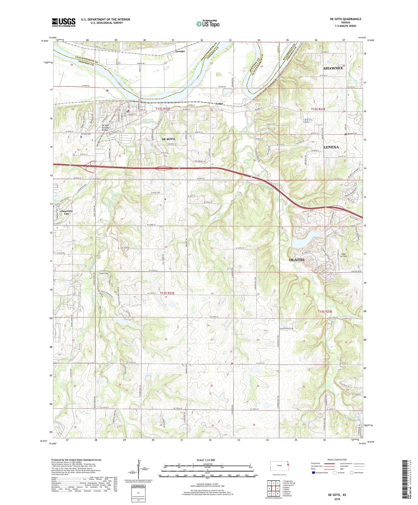
2022 topographic map quadrangle De Soto in the state of Kansas. Scale: 1:24000. Based on the newly updated USGS 7.5' US Topo map series, this map is in the following counties: Johnson, Leavenworth, Wyandotte. The map contains contour data, water features, and other items you are used to seeing on USGS maps, but also has updated roads and other features. This is the next generation of topographic maps. Printed on high-quality waterproof paper with UV fade-resistant inks.
Quads adjacent to this one:
West: Eudora
Northwest: Tonganoxie
North: Bonner Springs
Northeast: Edwardsville
East: Olathe
Southeast: Ocheltree
South: Gardner
Southwest: Edgerton
This map covers the same area as the classic USGS quad with code o38094h8.
Contains the following named places: B And L Mobile Home Park, Bosworth Mobile Home Park, Burning Tree Golf Club, Camp Creek, Cedar, Cedar Air Park, Cedar Creek, Cedar Creek Business Park, Cedar Creek Corporate Park, Cedar Creek Corporate Park East, Cedar Creek Corporate Park West, Cedar Creek Plaza Shops, Church of the Resurrection West, City of De Soto, Clearview Village Wastewater Treatment Plant, Countryside Learning Center School, De Soto, De Soto Baptist Church, De Soto Cemetery, De Soto Chamber of Commerce, De Soto City Hall, De Soto Fire and Rescue Department Station 1, De Soto Fire and Rescue Department Station 2, De Soto High School, De Soto Mobile Home Park, De Soto Post Office, De Soto Railroad Bridge, De Soto Unified School District Offices, De Soto Veterinary Clinic, Desoto Business Park, DeSoto Business Park, Desoto Library, Faith Builders International, First Assembly of God Church, Jewett Business Park, Johnson County Kill Creek Park North, Johnson County Kill Creek Park South, Johnson County Medical Action Station 191, Johnson County Rural Fire District 3 Station 2, Kill Creek, Kill Creek Park, Kill Creek Park Beach, Kill Creek Park Lake, Kill Creek Pond North, Kill Creek Pond South, Kill Creek Streamway Trail, Lenape, Lexington Center Shopping Center, Lexington Plaza Shopping Center, Lexington Trails Middle School, Little Cedar Creek, Mc Callum Veterinary Clinic, Merriam Community Center, Mill Creek Middle School, Miller Memorial Park, Mize Elementary School, Moonlight School, Murphy Cemetery, New Olathe Lake Dam, North Lake Center, North Lone Elm School, Northwest Consolidated Fire District Station 191, Oak Country Club, Olathe Harold Wastewater Treatment Plant, Pingleton Mobile Home Park, Prairie Center Pond, Shadow Glen Golf Club, Spoon Creek, Starside Elementary School, Station 2, Station 35 Emergency Medical Services, Station Number 2, Sunflower Pond B Dam, Sunflower Quarry, Timberridge Adventure Center, Township of Lexington, Township of Olathe, United Methodist Church of Desoto, Warsop Mobile Home Park, Weaverly School, ZIP Codes: 66018, 66061