MyTopo
Chanute Kansas US Topo Map
Couldn't load pickup availability
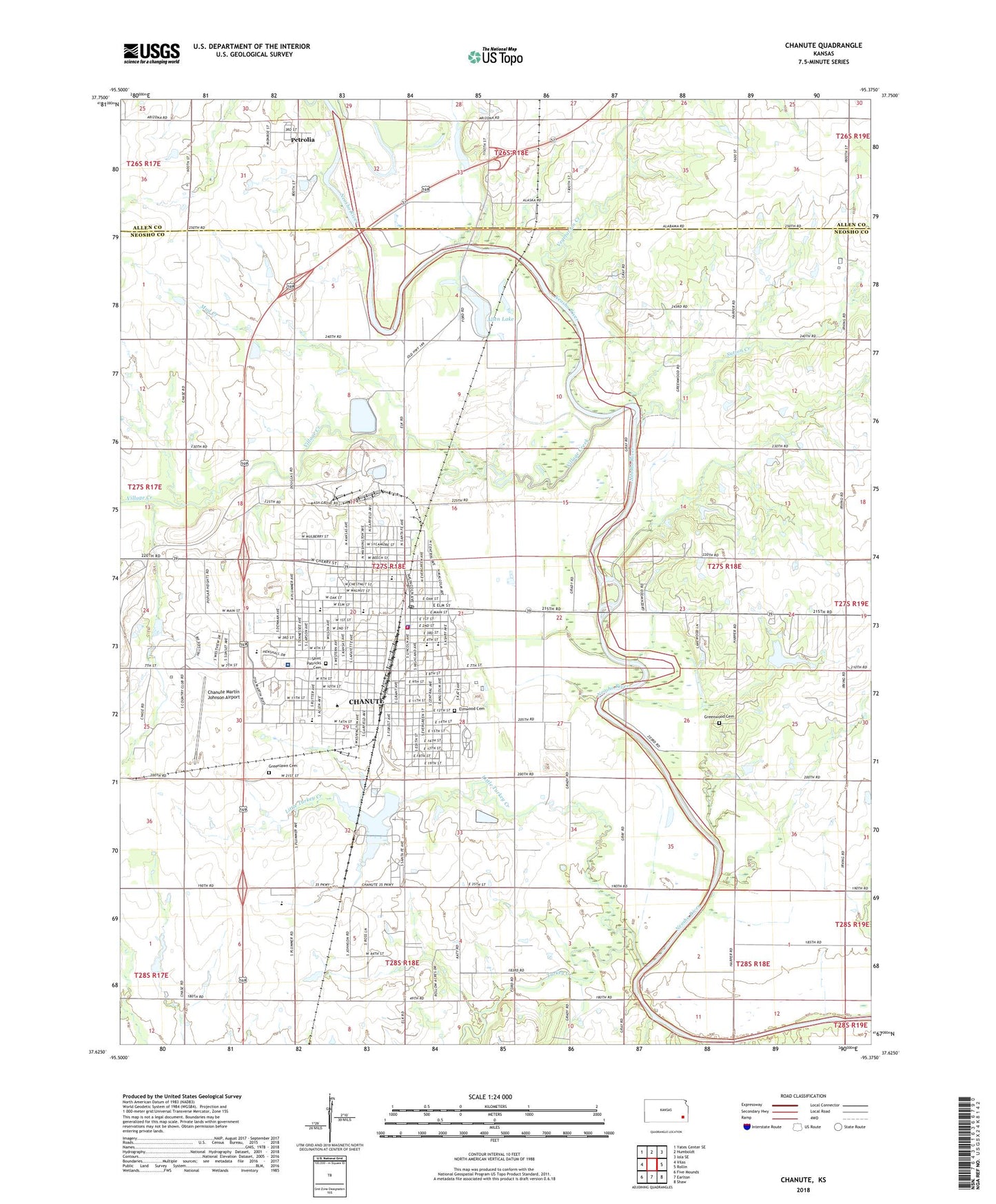
2022 topographic map quadrangle Chanute in the state of Kansas. Scale: 1:24000. Based on the newly updated USGS 7.5' US Topo map series, this map is in the following counties: Neosho, Allen. The map contains contour data, water features, and other items you are used to seeing on USGS maps, but also has updated roads and other features. This is the next generation of topographic maps. Printed on high-quality waterproof paper with UV fade-resistant inks.
Quads adjacent to this one:
West: Vilas
Northwest: Yates Center SE
North: Humboldt
Northeast: Iola SE
East: Rollin
Southeast: Shaw
South: Earlton
Southwest: Five Mounds
This map covers the same area as the classic USGS quad with code o37095f4.
Contains the following named places: Alcott Charter School, Alcott Elementary School, Allen Lake, Ambassador Christian Church, Austin, Barker Dam, Beachner Grain Elevator Number 6, Bethel Baptist Church, Blessed Hope Bible Baptist Church, Calvary Temple, Central Park, Chanute, Chanute Chamber of Commerce, Chanute Christian Academy, Chanute Church of God in Christ, Chanute Church of the Nazarene, Chanute City Hall, Chanute Country Club, Chanute Electric Department Plant Number 1, Chanute Electric Department Plant Number 2, Chanute Elementary School, Chanute Fire Department, Chanute High School, Chanute Martin Johnson Airport, Chanute Memorial Auditorium, Chanute Police Department, Chanute Post Office, Chanute Public Library, Chanute Seventh Day Adventist Church, Cherry Street Youth Center East, Cherry Street Youth Center West, Church of Christ, City of Chanute, Community of Christ, Cornerstone Family Life Center, Cottage Grove School, Elmwood Cemetery, Fairfield Elementary School, Faith Bible Church, Fellowship Tabernacle, First Baptist Church, First Christian Church, First Church of God, First Presbyterian Church, First United Methodist Church, Grace Episcopal Church, Grant Avenue Baptist Church, Grant Chapel African Methodist Episcopal Church, Greenlawn Cemetery, Greenwood Cemetery, Harmony School, Healing Center Church of God, Highland Avenue United Brethren in Christ Church, Highland Park, Hutton Elementary School, Hutton School, Kansas Department of Health and Environment Southeast District Office, Kansas Department of Transportation District Four Office, Kansas Department of Wildlife and Parks Region 5 Headquarters, Kansas Highway Patrol Troop H Chanute, Katy Park, Kingdom Hall of Jehovah's Witnesses, KKOY-AM (Chanute), KQSM-FM (Chanute), Lincoln Early Learning Center, Little Turkey Creek, Living Word Assembly of God Church, Martin and Osa Johnson Safari Museum, Mud Creek, Murray Hill Elementary School, Neosho County Community College - Chanute, Neosho County Courthouse Chanute, Neosho County Health Department, Neosho Memorial Regional Medical Center, Neosho Memorial Regional Medical Center Heliport, Neosho Station, Neosho Valley School, New Hope Missionary Baptist Church, North Valley School, Otterbein United Methodist Church, Parkview Holiness Church, Petrolia, Petrolia Wastewater Plant, Reachout Christian Center, Rollow Airport, Roosevelt Elementary School, Royster Chanute Community Learning Center, Royster Middle School, Safari Public Golf Course, Saint Patrick Catholic Church, Saint Patrick Catholic School, Saint Patricks Cemetery, Santa Fe Lake, Santa Fe Safari Campground, School Number 44, Sutton Creek, The Wesleyan Church, Township of Tioga, Transcare of Kansas Ambulance, Turkey Creek, Union School, Vegetarian Creek, Village Creek, Westview Southern Baptist Church, Zion Lutheran Church, ZIP Code: 66720