MyTopo
Derby Kansas US Topo Map
Couldn't load pickup availability
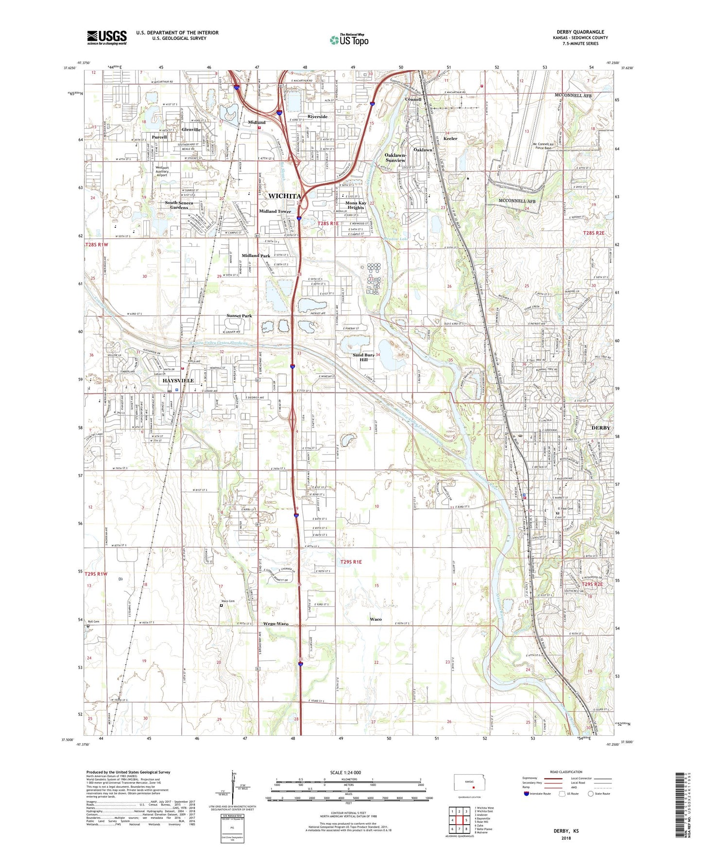
2022 topographic map quadrangle Derby in the state of Kansas. Scale: 1:24000. Based on the newly updated USGS 7.5' US Topo map series, this map is in the following counties: Sedgwick. The map contains contour data, water features, and other items you are used to seeing on USGS maps, but also has updated roads and other features. This is the next generation of topographic maps. Printed on high-quality waterproof paper with UV fade-resistant inks.
Quads adjacent to this one:
West: Bayneville
Northwest: Wichita West
North: Wichita East
Northeast: Andover
East: Rose Hill
Southeast: Mulvane
South: Belle Plaine
Southwest: Zyba
This map covers the same area as the classic USGS quad with code o37097e3.
Contains the following named places: 63rd and South Seneca Church of Christ, 67060, 67216, 67217, Air Capital Mobile Home Park, Ark Valley Christian Church, Audora Mobile Home Park, Bayless Industrial Park, Beyer Farm Airport, Big Slough, Blood School, Boeing Hi - Tech Office Park, Boeing Industrial Park, Broadway 47 Plaza, Buu Quang Temple, Cambridge Mobile Home Park, Campus High School, Carlton Grade School, Carlton School, Caudill Mobile Home Park, Cedar Ridge Mobile Home Park, Cessna Elementary School, Chelsea Industrial Park, Church of the Bible Covenant, City of Derby, City of Haysville, Colonial Heights Assembly of God Church, Conestoga Mobile Home Park, Connell, Deer Lake Mobile Home Estates, Derby, Derby Business Park, Derby Christian School, Derby Fire and Rescue Department Station 81, Derby Hills Elementary School, Derby Historical Museum, Derby Industrial Park, Derby Middle School, Derby Police Department, Derby Post Office, Derby Recreation Center, Derby Sixth Grade Center, Derby Wastewater Treatment Facility Plant Number 2, Dixon Square, Dry Creek, Early Childhood Center, El Caudillo Mobile Home Park, El Paso Cemetery, El Paso Elementary School, Emery Park, Englewood Mobile Home Park, English Park, Enterprise Christian Church, Faith Christian Church, Faith Lutheran Church, Faith Lutheran School, First Christian Church of Haysville, First Pentecostal United Church, Forty Seventh Street Church of Christ, Freeman Elementary School, Funston Elementary School, Gladys, Glen Acres Mobile Home Park, Glenville, Glenville Bible Baptist Church, Good Shepherd Lutheran Church, Grand Avenue Industrial Park, Hand Park, Harbor Mobile Home Park, Hardison Shady Acres Mobile Home Park, Harmony Southern Baptist Church, Harvest Chapel Community Church, Haysville, Haysville Activity Center, Haysville Charter School, Haysville City Hall, Haysville Community Library, Haysville Healthcare Center Nursing Home, Haysville Middle School, Haysville Municipal Court, Haysville Police Department, Haysville Post Office, Haysville Senior Center, Haysville United Methodist Church, Haysville Wastewater Plant, Interstate 135 Turnpike Business Park, K 15 Industrial Park, KDGS - FM (Wichita), Keeler, KGCS-FM (Derby), Kuhns Mobile Home Park, Lakeview Mobile Home Park, Lamplighter Mobile Home Park, MacArthur Place Mobile Home Park, McConnell Air Force Base Census Designated Place, Meadow Lake, Midland, Midland Park, Midland Tower, Midway Baptist Church, Midway Christian School, Midway Southern Baptist Church, Mobile Manor Estates Mobile Home Park, Mona Kay Heights, Nelson Elementary School, Oaklawn, Oaklawn Elementary School, Oaklawn Place Baptist Church, Oaklawn-Sunview Census Designated Place, Oakview Christian Church, Oakwood Manor Mobile Home Park, Orchard Community Church, Pacesetter Mobile Home Park, Park Avenue Estates Mobile Home Park, Paul B Cooper Elementary School, Peachwood Manor Mobile Home Park, Peck Substation, Pinaire Mobile Home Park, Pine Bay Golf Course, Pleasant Valley School, Pleasantview Elementary School, Prairie Elementary School, Purcell, Rex Elementary School, Riley Park, River Oaks Mobile Home Park, Riverside, Rock Island Industrial Park, Roll Cemetery, Rolling Green Mobile Home Park, Ruth Clark Elementary School, Saint Andrews Episcopal Church, Saint Cecilia Catholic School, Saint Cecilia Church, Sand Burr Hill, School Number 57, Sedgwick County Emergency Medical Service Post 6, Sedgwick County Fire District 1 Station 34, Sedgwick County Fire District 1 Station 36, Selby Farm Airport, Sherwood Acres Mobile Home Park, Silver Spur Mobile Home Park, South Broadway Industrial Park, South City Center, South Riverside Baptist Church, South Seneca Gardens, South Wichita School, Southborough Estates Mobile Home Park, Spirit Aero Systems Fire Department, Spring Creek, Sunset Park, Sunview Mobile Home Park, Swaney Elementary School, Sycamore Square Mobile Home Park, The Derby Golf and Country Club, The Woodlands Mobile Home Park, Thompsons Mobile Home Park, Timbercreek Mobile Home Park, Township of Riverside, Township of Salem, Tri - City Day School, Twin Lakes Golf Course, Twin Oaks Estates Mobile Home Park, Waco, Waco Cemetery, Waco School, Wayne Smith Mobile Home Park, Wego-Waco, Westport Auxiliary Airport, Westview Manor Nursing Home, White Elementary School, Wichita Area Technical College Southside Campus, Wichita Fire Department Station 19, Wichita Lower Arkansas River Sewage Treatment Plant, Wichita-Valley Center Floodway, Willowood Estates Mobile Home Park, Woodlands Mobile Home Park, Young Mobile Home Park