MyTopo
Junction City Kansas US Topo Map
Couldn't load pickup availability
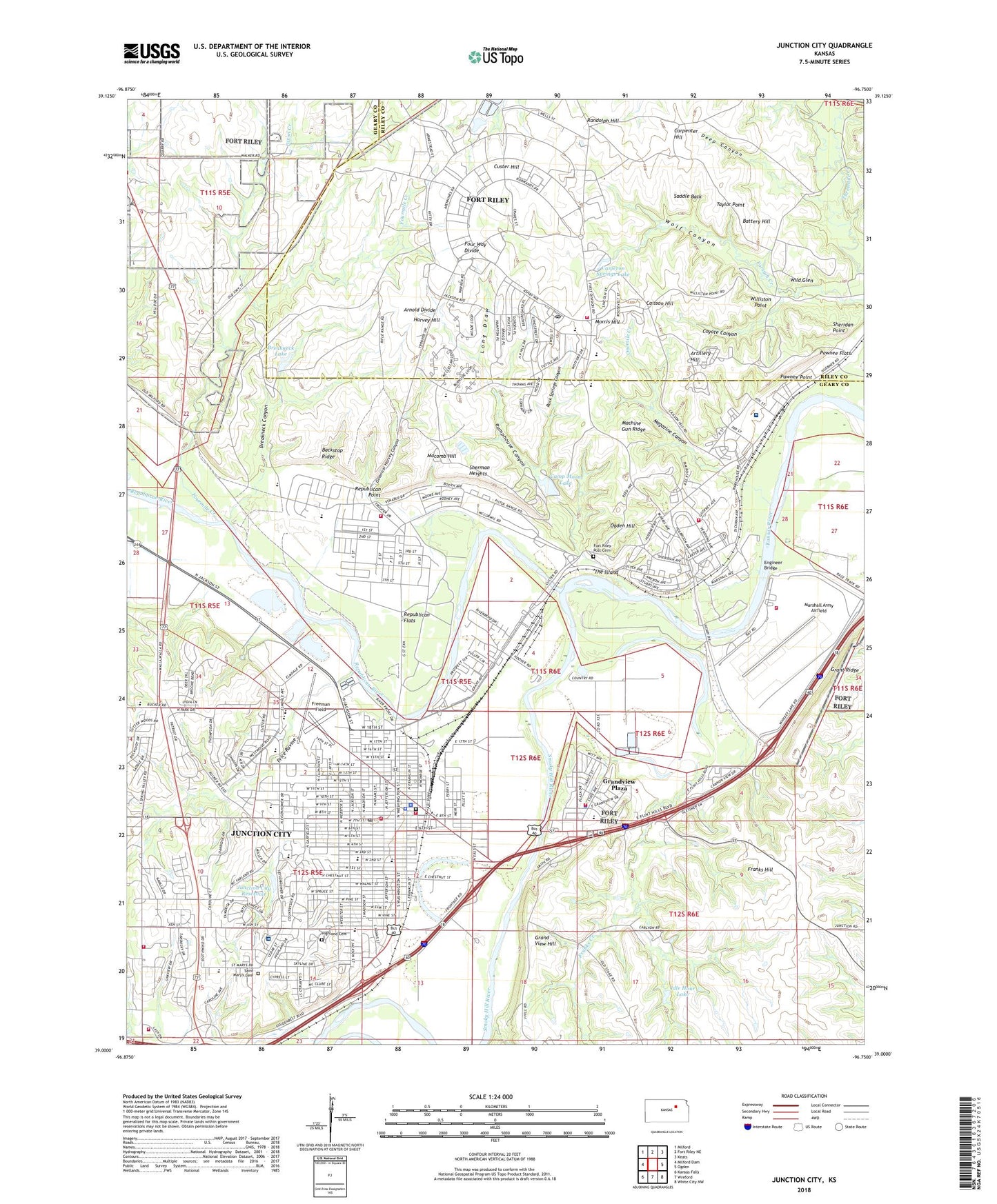
2022 topographic map quadrangle Junction City in the state of Kansas. Scale: 1:24000. Based on the newly updated USGS 7.5' US Topo map series, this map is in the following counties: Geary, Riley. The map contains contour data, water features, and other items you are used to seeing on USGS maps, but also has updated roads and other features. This is the next generation of topographic maps. Printed on high-quality waterproof paper with UV fade-resistant inks.
Quads adjacent to this one:
West: Milford Dam
Northwest: Milford
North: Fort Riley NE
Northeast: Keats
East: Ogden
Southeast: White City NW
South: Wreford
Southwest: Kansas Falls
This map covers the same area as the classic USGS quad with code o39096a7.
Contains the following named places: Apostolic Academy, Arnold Divide, Artillery Hill, Backstop Ridge, Battery Hill, Breakneck Canyon, Breakneck Dam, Breakneck Lake, C L Hoover Opera House, Caisson Hill, Calvary Baptist Church, Cameron Springs Lake, Camp Moon Lake, Camp Moon Lake Dam, Camp Whitside, Carpenter Hill, Church of Christ, Church of Deliverance, Church of God in Christ, City of Grandview Plaza, City of Junction City, Cleary Park, Coronado Park, Cottonwood Mobile Home Estates, Coyote Canyon, Custer Hill, Custer Hill Elementary School, Custer Hill Golf Course, Custer House, Deep Canyon, Dixon Creek, Dorothy Bramlage Public Library, Eisenhower Elementary School, Engineer Bridge, Episcopal Church of the Covenant, Faith Lutheran Church, Faith Tabernacle Apostolic Church, Filby Park, First Baptist Church, First Christian Church, First Infantry Division Museum, First Presbyterian Church, First United Methodist Church, Fort Riley, Fort Riley Census Designated Place, Fort Riley Elementary School, Fort Riley Emergency Medical Services, Fort Riley Fire Department Station 1, Fort Riley Fire Department Station 2, Fort Riley Fire Department Station 3, Fort Riley Fire Department Station 5, Fort Riley Middle School, Fort Riley Post Cemetery, Fort Riley Post Office, Fort Riley-Camp Whiteside Census Designated Place, Four Seasons Mobile Home Estates, Four Way Divide, Fourmile Creek, Franklin Elementary School, Franks Creek, Franks Hill, Freedom Park, Freeman Field, Geary Community Hospital, Geary County, Geary County Courthouse, Geary County Detention Center, Geary County Fairgrounds, Geary County Health Department, Geary County Historical Society and Museums, Geary County Rural Fire Department Station 1, Geary County Rural Fire Department Station 3, Geary County Sheriff's Office, Governor Harvey Canyon, Grand View Hill, Grandview Elementary School, Grandview Plaza, Grandview Plaza City Hall, Grandview Plaza Fire Department, Grandview Plaza Police Department, Grandview Plaza Wastewater Treatment Facility, Grant Ridge, Harvey Hill, Highland Baptist Church, Highland Cemetery, Idle Hour Lake, Iglesia Centro Hispano Maranatha, Immanuel Lutheran Church, Immanuel Lutheran School, Irwin Army Community Hospital, Jefferson Elementary School, Junction City, Junction City Art Gallery, Junction City Chamber of Commerce, Junction City Church of the Nazarene, Junction City Country Club, Junction City Fire Department Headquarters, Junction City Fire Department Station 2, Junction City First Assembly of God Church, Junction City High School, Junction City Municipal Building, Junction City Police Department, Junction City Post Office, Junction City Regency Mobile Home Park, Junction City Reservoir, Junction City Seventh Day Adventist Church, Junction City Wastewater Department, Junction Full Gospel Church, K S Hauge Alternative Education Center, Kansas First Territorial Capitol, Kansas National Guard Armory Junction City, Kingdom Hall of Jehovah's Witnesses, KJCK-AM (Junction City), KJCK-FM (Junction City), Korean Grace Baptist Church, Korean Junction City United Methodist Church, Legacy Community Church, Life Star of Kansas Medical Transport, Lighthouse Christian Fellowship Church of God, Lincoln Elementary School, Living Word of Christ Church, Long Draw, Lutheran School, Machine Gun Ridge, Macomb Hill, Magazine Canyon, Marshall Army Airfield, Max Heim Early Childhood Center, Midway Mobile Home Park, Miller Mobile Home Court, Morris Hill, Morris Hill Elementary School, Mullins Park, New Church of the Living God, New Testament Christian Church, North Central Kansas Regional Juvenile Detention Facility, Northwind Mobile Home Park, Ogden Hill, Onemile Creek, Our Savior United Methodist Church, Pawnee, Pawnee Flats, Pawnee Park, Pawnee Point, Price Ravine, Pumphouse Canyon, Randolph Hill, Rathert Stadium, Republican Flats, Republican Point, Republican River, Riley City, Rimrock Dam, Rimrock Park, Rock Springs Canyon, Saddle Back, Saint Francis Xavier Catholic Church, Saint Francis Xavier Catholic School, Saint Mary's Cemetery, Saint Xavier Elementary School, Scottish Square Mobile Home Park, Second Missionary Baptist Church, Sertoma Park, Sheridan Elementary School, Sheridan Point, Sherman Heights, Smoky Hill River, South Park, Spring Valley School, Taylor Point, The Church of Jesus Christ of Latter Day Saints, The Island, Township of Jefferson, Twelfth Street Community Center, United States Army Hospital, United States Cavalry Museum, Ward Chapel African Methodist Episcopal Church, Ware Elementary School, Washington Elementary School, Wesleyan Church, West Side Shopping Center, Westwood Elementary School, Whiskey Lake Raceway, Wild Glen, Williston Point, Wolf Canyon, Wyman Park, Zion United Church of Christ, ZIP Code: 66442