MyTopo
Blackey Kentucky US Topo Map
Couldn't load pickup availability
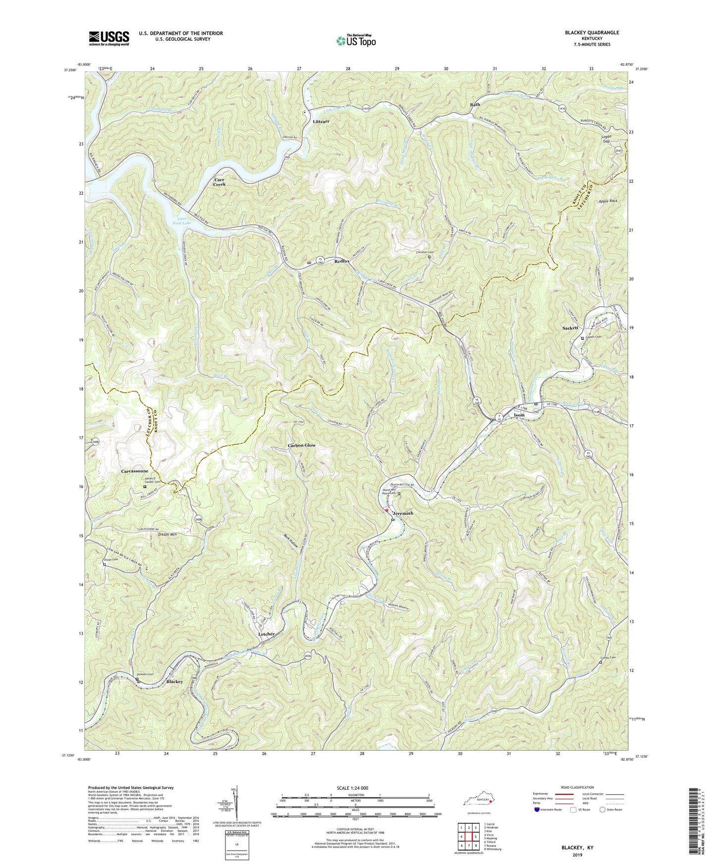
2022 topographic map quadrangle Blackey in the state of Kentucky. Scale: 1:24000. Based on the newly updated USGS 7.5' US Topo map series, this map is in the following counties: Letcher, Knott. The map contains contour data, water features, and other items you are used to seeing on USGS maps, but also has updated roads and other features. This is the next generation of topographic maps. Printed on high-quality waterproof paper with UV fade-resistant inks.
Quads adjacent to this one:
West: Vicco
Northwest: Carrie
North: Hindman
Northeast: Kite
East: Mayking
Southeast: Whitesburg
South: Roxana
Southwest: Tilford
This map covers the same area as the classic USGS quad with code o37082b8.
Contains the following named places: Adams Branch, Addie-Litcar Post Office, Amburgey Post Office, Amelia, Apple Rock, Back Hollow, Bath, Bath Post Office, Bee Tree Branch, Beefork Post Office, Beetree Branch, Bennett Adams Church, Betze Post Office, Big Doubles Branch, Big Doubles School, Black John Branch, Blackey, Blackey Post Office, Blackey Railroad Station, Blackey School, Blair Branch, Blair Branch Church, Blair Branch School, Breed School Number Fifteen, Breeding Branch, Breeding Creek, Breeding Creek School Number Eight, Buffalo School, Buncombe Post Office, Calvary College, Carbon Glow, Carbon Glow Church, Carbon Glow School, Carcassonne, Careassone Post Office, Careassonne Community Center, Carr Creek, Carr Creek School, Carr Fork Lake, Caudill Creek, Christon Cemetery, City of Blackey, Cody, Cody Bible Church, Cody Bible Church Evangical Free, Cody Cemetery, Cody Post Office, Combs Cemetery, Crases Branch, Critic Post Office, Daniels Branch, David Post Office, Dead Mare Branch, Deerlick Branch, Defeated Creek, Defeated Creek School, Dickson Cemetery, Dikson Mountain, Dirk Post Office, Dixon Cemetery, Dixon Memorial Church, Does Post Office, Doty Church, Doty Creek, Doty School, Duo Railroad Station, Elco Railroad Station, Elk Creek, Elk Creek School, Elkhorn Branch, Flax Patch School, Flaxpatch Branch, Garner Creek, Gibson Cemetery, Grouse Post Office, Hale Branch, Happy Home of Regular Baptist Church, Hemelock Post Office, Hollybush Branch, Horse Mill Point Cemetery, Hot Spot, Hot Spot School, Indian Bottom, Indian Bottom Church, Indian Bottom Post Office, Irishman Creek, Irishmans, Isom, Isom Census Designated Place, Isom Post Office, James Caudill Historical Marker, James D Caudill Cemetery, James Memorial Church, Jent Post Office, Jeremiah, Jeremiah Post Office, Jeremiah School, Johnson Branch, Joseph Post Office, Letcher, Letcher County High School, Letcher County Historical Marker, Letcher Fire and Rescue Ambulance Service, Letcher Independence Church, Letcher Post Office, Lick Branch, Littcarr, Little Carr Bible School, Little Carr Fork, Little Colly Creek, Little Doubles Branch, Little Home Church, Little Smith Branch, Logan Gap, Low Gap Branch, Marshal Branch, Middle Carr Creek, Mouth of Daniel School, Mouth of Trace School, Old Carr Church, Perkins Branch, Pine Grove School, Pratts Branch, Redfox, Redfox Post Office, Right Fork Doty Creek, Rockhouse Creek, Sackett, School Number One, School Number Seven, School Number Six, School Number Three, Shingle Branch, Smith Branch, Smiths Post Office, Smithsboro, Smithsboro Baptist Church, Smithsboro post office, Smithsboro School Number Seven, Smoot Creek Post Office, Spring Branch, Stampers Branch, Sugar Branch, Tana Post Office, Tayma Railroad Station, The Stock Sale, Theodore Post Office, Upper Smith Branch School, Van Post Office, Veen Post Office, Walbot Railroad Station, Walters Branch, Witch Post Office, Wolfpen Branch, Wolfpen Creek, Wolfpen School, ZIP Codes: 41826, 41832, 41836, 41845, 41847