MyTopo
Kite Kentucky US Topo Map
Couldn't load pickup availability
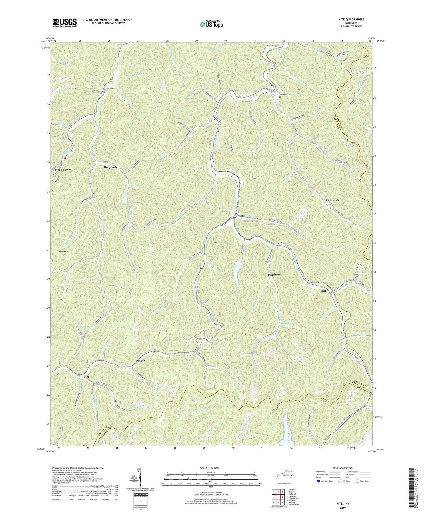
2022 topographic map quadrangle Kite in the state of Kentucky. Scale: 1:24000. Based on the newly updated USGS 7.5' US Topo map series, this map is in the following counties: Knott, Letcher, Floyd. The map contains contour data, water features, and other items you are used to seeing on USGS maps, but also has updated roads and other features. This is the next generation of topographic maps. Printed on high-quality waterproof paper with UV fade-resistant inks.
Quads adjacent to this one:
West: Hindman
Northwest: Handshoe
North: Wayland
Northeast: McDowell
East: Wheelwright
Southeast: Jenkins West
South: Mayking
Southwest: Blackey
This map covers the same area as the classic USGS quad with code o37082c7.
Contains the following named places: Adams Lookout Tower, Alice Lloyd College, Amazon Post Office, Arnold Fork, Bald Hill Cemetery, Bates Branch, Beaver Creek Division, Beaver Creek Elementary School, Beaver Gap, Bill D Branch, Bill Dees Branch School, Bloomer Branch, Buck Branch, Buffalo Branch, Buzzer Branch, Calfpen Branch, Caney Creek School, Carson Post Office, City of Pippa Passes, Collins Branch, Cottonpatch Branch, Crager Fork, Drew, Drew Post Office, Dry Creek, Dry Creek Post Office, Ellis Lick, Gauley Branch, Hall, Hall Branch, Hall Cemetery, Hall Post Office, Hall School, Head of Carr School, Head of Hollybush School, Hemp Patch Bottom, Hemppatch Branch, Holbrook Branch, Holly Bush Old Regular Baptist Church, Holly Bush Post Office, Holly Bush School, Hollybush, Hollybush Church, Hollybush Creek, Isaac Fork, Ivan Post Office, Joe King Branch, Kite, Kite - Topmost Fire Department, Kite Post Office, Kite School, Left Dry Creek School, Left Fork Dry Creek, Left Fork Holly Bush Creek, Martinsville, May, May Post Office, Meadow Branch, Middle Hollybush School, Mill Creek Church, Mouth of Hollybush School, Mullins Branch, Mullins True Baptist Church, Nealy, Nealy Branch, Nealy Branch School, Nealy Post Office, Oldhouse Branch, Oldhouse Creek, Omaha, Omaha Bible Church, Onion Blade Branch, Panther Lick, Patton School, Pippa Passes, Pippa Passes Fire Department, Potato Branch, Poundmill Branch, Providence Baptist Church, Punchean Post Office, Puncheon, Puncheon Branch, Puncheon School, Rebecca Old Regular Baptist Church, Republican Post Office, Right Dry Creek School, Righthand Fork, Roaring Branch, Rocklick Branch, Ropeworks Branch, School Number Fifteen, School Number Four, Scip Branch, Spicewood Branch, Spring Branch, Sylvester, Topmost, Topmost Post Office, Trace Mountain, Upper Beaver School, Weissert Post Office, West Fork, WOAL-FM (Pippa Passes), ZIP Codes: 41828, 41843, 41844, 41862