MyTopo
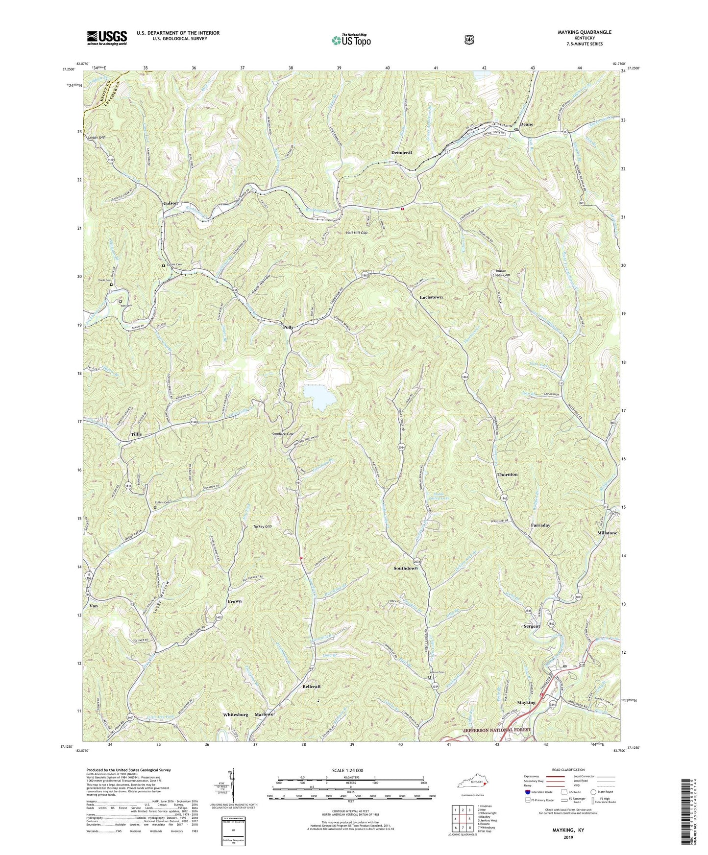
Mayking Kentucky US Topo Map
Couldn't load pickup availability
Also explore the Mayking Forest Service Topo of this same quad for updated USFS data
2022 topographic map quadrangle Mayking in the state of Kentucky. Scale: 1:24000. Based on the newly updated USGS 7.5' US Topo map series, this map is in the following counties: Letcher, Knott. The map contains contour data, water features, and other items you are used to seeing on USGS maps, but also has updated roads and other features. This is the next generation of topographic maps. Printed on high-quality waterproof paper with UV fade-resistant inks.
Quads adjacent to this one:
West: Blackey
Northwest: Hindman
North: Kite
Northeast: Wheelwright
East: Jenkins West
Southeast: Flat Gap
South: Whitesburg
Southwest: Roxana
This map covers the same area as the classic USGS quad with code o37082b7.
Contains the following named places: Adams Post Office, Allen Branch, Appletree Branch, Arch Post Office, Bastin Railroad Station, Beaverdam Branch, Beaverdam School, Bellcraft, Big Branch, Big Branch School, Blair Branch, Bottom Fork, Buck Creek, Camp Branch, Camp Branch Chapel, Camp Branch School, Camp Fork, Cane Fork, Cane Hollow, Cap Post Office, Collie Post Office, Collins Cemetery, Colson, Colson Division, Colson Post Office, Colson School, Colson Volunteer Fire Department, Colsons School, Combs Branch, Company Branch, Cook Cemetery, Cow Branch, Cow Branch School, Craftsville, Cram Creek, Crown, Crown Post Office, Deane, Deane Post Office, Deane School Number Five, Democrat, Dick Branch, Dry Fork Church, Effie Post Office, Fairchild Branch, Fall Post Office, Farraday, Franklin Branch, Friday Branch, Gap Branch, Hall Hill Gap, Hillird Post Office, Holbrook Post Office, Hurricane Branch, Indian Creek, Indian Creek Gap, Ison Cemetery, Jim Hogg Branch, Left Fork Millstone Creek, Lester Post Office, Lick Branch, Licking Rock Branch, Little Colly, Little Colly Church, Little Dry Fork, Logan Gap, Loggy Hollow, Long Branch, Loves Branch, Lower Appletree Branch, Lower Crafts Colly School, Lower Gap Branch, Lower Millstone School, Lucas Post Office, Lucastown, Marlowe, Marlowe School, Mayking, Mayking Census Designated Place, Mayking Post Office, Mayking Railroad Station, Mayking School, Mayking Volunteer Fire Department, Meade Post Office, Melvin Adams Cemetery, Middle Colly School, Middle Dry Fork School, Middle Millstone School, Mill Creek, Millstone, Millstone Branch, Millstone Creek, Millstone Post Office, Persimmon Branch, Pine Creek, Polly, Polly Branch, Polly Railroad Station, Razor Blade Post Office, Razorblade Branch, Rhoades Branch, Right Fork Millstone Creek, Rockhouse Church, Rockhouse Post Office, Sandlick Gap, Sandlick Post Office, Sandlick Volunteer Fire Department, School Number Five, School Number One, School Number Six, Schuler Branch, Sergeant Church, Sergeant Post Office, Sergeant School, Sergent, Smoot Creek, Smoot Creek School, Snake Valley Lake, Southdown, Southdown Post Office, Sugar Branch, Thicket Branch, Thompson Branch, Thornton, Thornton Creek, Thornton Gap, Thornton Gap School, Thornton Post Office, Thornton Regular Baptist Church, Thornton School, Thorton Gap School, Tillie, Tillie Post Office, Tocsin Post Office, Trace Fork, Turkey Gap, Tyra Post Office, Upper Colly School, Upper Dry Fork School, Van, Webb Branch, Whitesburg Division, Whitesburg Municipal Airport, Wolfpen Branch, WTCW-AM (Whitesburg), Yellowhouse Branch, ZIP Codes: 41815, 41824, 41837, 41838, 41855, 41858