MyTopo
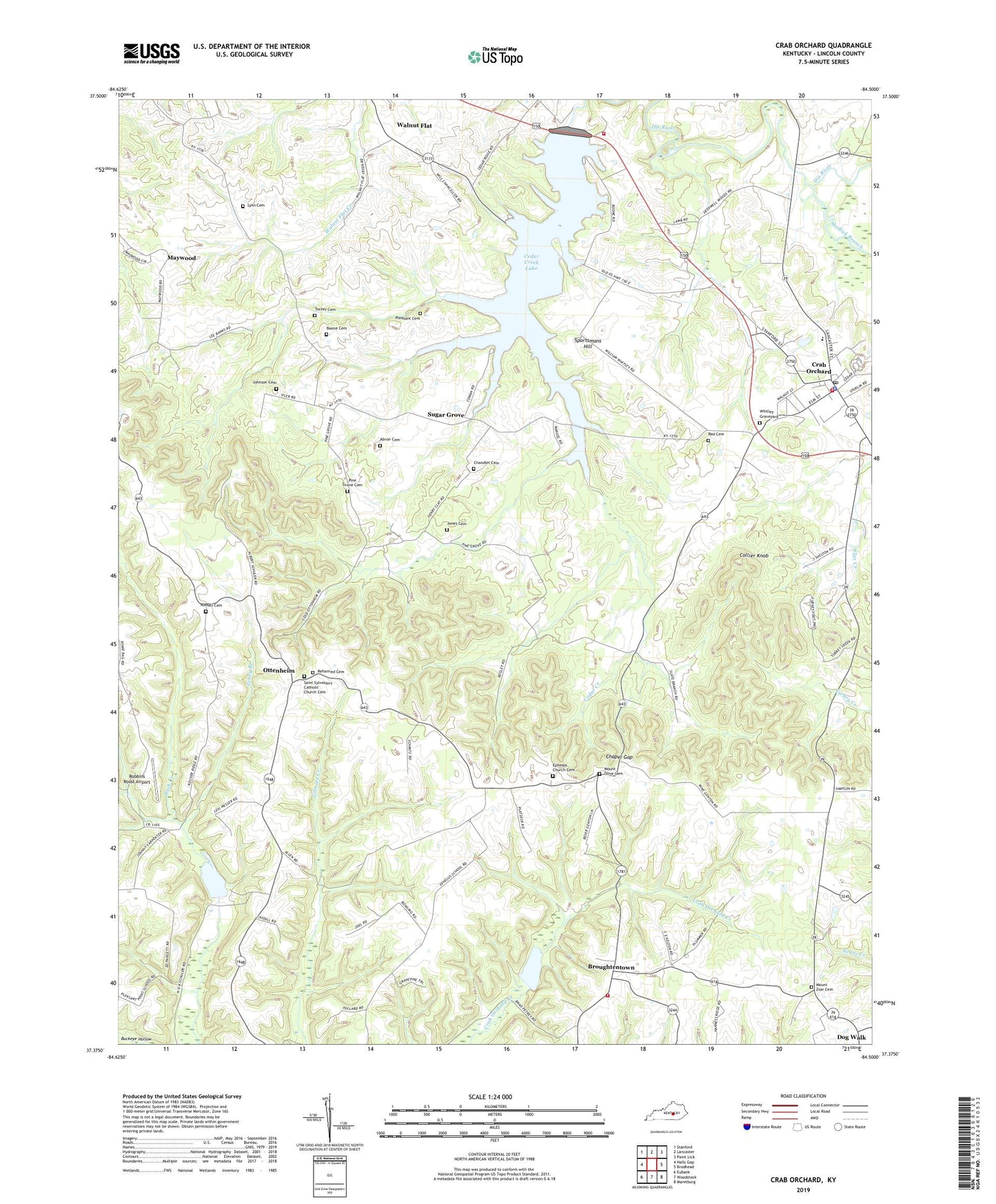
Crab Orchard Kentucky US Topo Map
Couldn't load pickup availability
2022 topographic map quadrangle Crab Orchard in the state of Kentucky. Scale: 1:24000. Based on the newly updated USGS 7.5' US Topo map series, this map is in the following counties: Lincoln. The map contains contour data, water features, and other items you are used to seeing on USGS maps, but also has updated roads and other features. This is the next generation of topographic maps. Printed on high-quality waterproof paper with UV fade-resistant inks.
Quads adjacent to this one:
West: Halls Gap
Northwest: Stanford
North: Lancaster
Northeast: Paint Lick
East: Brodhead
Southeast: Maretburg
South: Woodstock
Southwest: Eubank
This map covers the same area as the classic USGS quad with code o37084d5.
Contains the following named places: Abron Cemetery, Albright Post Office, Avondale, Avoy Post Office, Beech Grove Church, Boone Cemetery, Broughtentown, Buck Creek, Cedar Creek, Cedar Creek Lake, Cedar Creek Railroad Station, Cedar Ridge Church, Chandler Cemetery, Chapel Gap, Chapel Gap Methodist Church, Chapel Gap School, City of Crab Orchard, Collier Knob, Colliers Store, Crab Orchard, Crab Orchard Baptist Church, Crab Orchard Division, Crab Orchard Fire Department, Crab Orchard Police Department, Crab Orchard Post Office, Dog Walk, Double Springs, East End Ambulance Service, Ephesos Church, Ephesos Church Cemetery, Ephesos School, Ephesus, Fenny Branch, Hebron Church, Holdams Mill, Johnson Cemetery, Jones Cemetery, Kriger Post Office, Lincoln County Fire Department Station 2, Lincoln County Fire Department Station 6, Lutheran Saint Johannas Reformed Church, Lynn Cemetery, Maywood, Maywood Post Office, Maywood Railroad Station, Moores Station, Mount Hebron Baptist Church, Mount Olive Cemetery, Mount Olive Church, Mount Zion Cemetery, Mount Zion Church, Mudlick Branch, New Hope Church, Orphans Home, Ottenheim, Ottenheim Post Office, Ottenheim School, Peoples Corner, Pine Grove, Pine Grove Cemetery, Pine Grove Church, Pine Grove School, Pleasant Cemetery, Red Cemetery, Reformed Cemetery, Robbins Roost Airport, Russell Cemetery, Saint Sylvester Church, Saint Sylvesters Catholic Church Cemetery, Sportsmans Hill, Sugar Grove, Sugar Grove Church, Sugar Grove School, Tucker Cemetery, Walnut Flat, Walnut Flat Post Office, Walnut Flat School, Whitley Graveyard, Whitleys Station, William Whitley House State Shrine