MyTopo
Evarts Kentucky US Topo Map
Couldn't load pickup availability
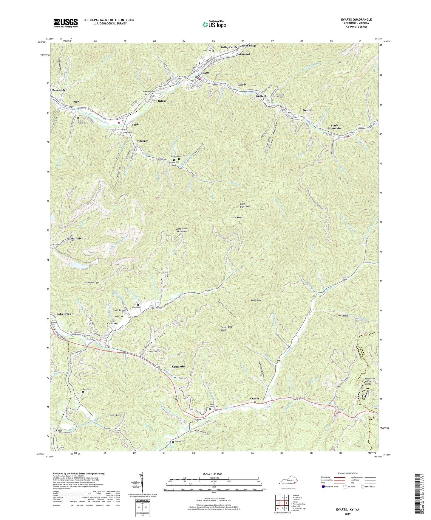
2022 topographic map quadrangle Evarts in the state of Kentucky. Scale: 1:24000. Based on the newly updated USGS 7.5' US Topo map series, this map is in the following counties: Harlan, Lee. The map contains contour data, water features, and other items you are used to seeing on USGS maps, but also has updated roads and other features. This is the next generation of topographic maps. Printed on high-quality waterproof paper with UV fade-resistant inks.
Quads adjacent to this one:
West: Harlan
Northwest: Bledsoe
North: Nolansburg
Northeast: Louellen
East: Pennington Gap
Southeast: Ben Hur
South: Hubbard Springs
Southwest: Rose Hill
Contains the following named places: Ages, Ages Census Designated Place, Ages Creek, Ages Post Office, Ages Railroad Station, Bailey Creek, Bailey Post Office, Barn Branch, Bear Branch, Big Branch, Black Mountain, Bobs Creek, Bobs Creek Post Office, Bridge Branch, Britton Creek, Britton Creek Church, Brookside, Burgoyne Branch, Burkhart Cemetery, Casco Railroad Station, Cassity Railroad Station, Cato Railroad Station, Cawood, Cawood Branch, Cawood Cemetery, Cawood Census Designated Place, Cawood Division, Cawood Post Office, Cawood Railroad Station, Chestnut Branch, City of Evarts, Cranks, Cranks Creek Wildlife Management Area, Cranks Post Office, Cranks Ridge, Crummies, Crummies Creek, Crummies Post Office, Crummies Railroad Station, Crummies Spur, Cutshin Hollow, Darby Coal Mining Camp, Darby Coal Mining Camp Railroad Station, Darbytown, Darkmont, Daves Branch, Days Branch, Draper, Draper Post Office, Evarts, Evarts Fire Department, Evarts Police Department, Evarts Post Office, Field Cemetery, Fisher Hollow, Fisk Railroad Station, Flager, Gabes Branch, Gabes Branch Cemetery, Grant Branch, Harcrow Railroad Station, Harlan County, Harnick Railroad Station, Howard Cemetery, Ikes Branch, James Creek, Jerry Branch, Jones Creek, Jones Creek School, Keith Post Office, Keith Railroad Station, Kelly Cemetery, Kenvir, Kenvir Census Designated Place, Kenvir Post Office, Kenvir Railroad Station Number Five, Kenvir Railroad Station Number Four, Kildav, Kildav Post Office, Kildav Railroad Station, Kitts Knob, Laurel Branch, Leadford Post Office, Left Fork Ages Creek, Left Fork Cranks Creek, Lick Branch, Little Black Lookout Tower, Little Creek, Little Creek Church, Little Creek School, Lone Spur, Long Branch, Lower Cloverfork Fire Department, Lower Halls Branch, Lower Laurel Branch, Martins Fork Fire and Rescue Department, Meadow Branch, Merna Railroad Station, Middle Fork Cranks Creek, Middle School, Middleton Cemetery, Mill Branch, Mill Creek, Mill Creek Church, Mill Creek School, Mill Ridge, Mill River Railroad Station, Myer Branch, Nims Branch, Parkdale Railroad Station, Penny Branch, Pillsbury Railroad Station, Pope Cemetery, Popeville Railroad Station, Pounding Mill Branch, Pounding Mill Cemetery, Raccoon Branch, Rainbow Cemetery, Redbud, Redbud Post Office, Redbud School, Reds Creek, Reids Branch, Right Fork Cranks Creek, Right Fork Turtle Creek, Road Branch, Schoolhouse Branch, Sharps Branch, Sikes Railroad Station, Skidmore Branch, Slack Cemetery, Slack Hollow, Smithville Post Office, Stillhouse Branch, Stone Mountain Park, Sugarcamp Branch, Sugarcamp Knob, Sulphur Spring Hollow, Sykes Railroad Station, Ten Spot, Thompson Branch, Trap Branch, Turner Branch, Turner Cemetery, Upper Cranks Creek School, Upper Halls Branch, Upper Laurel Branch, Verda, Verda Census Designated Place, Verda Post Office, Verda Railroad Station, Wash Smith Cemetery, Woods, Yocum Creek, Yocum Creek Fire Department, Yocum Creek Railroad Station, ZIP Codes: 40801, 40815, 40818, 40847