MyTopo
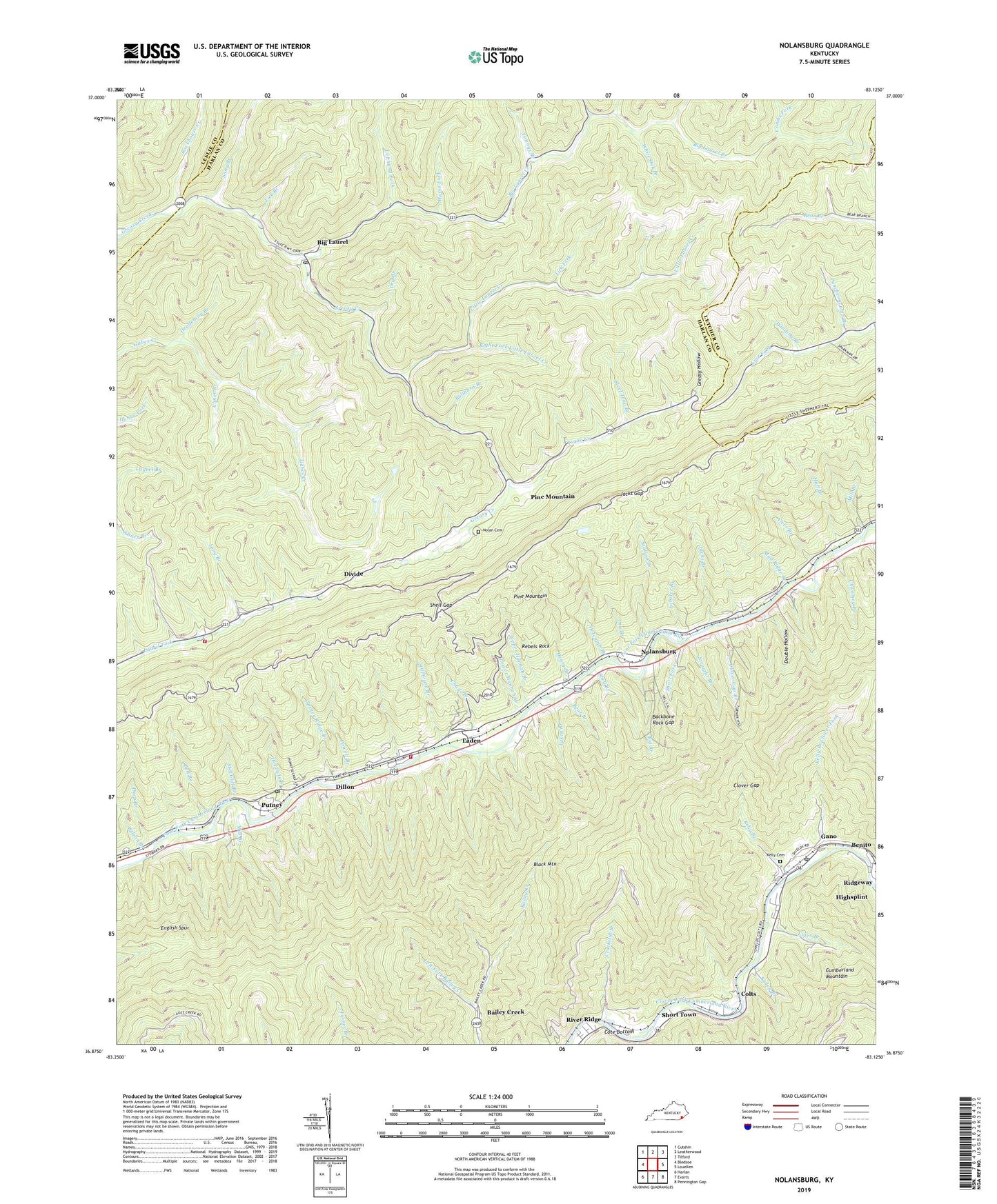
Nolansburg Kentucky US Topo Map
Couldn't load pickup availability
Also explore the Nolansburg Forest Service Topo of this same quad for updated USFS data
2022 topographic map quadrangle Nolansburg in the state of Kentucky. Scale: 1:24000. Based on the newly updated USGS 7.5' US Topo map series, this map is in the following counties: Harlan, Letcher, Leslie. The map contains contour data, water features, and other items you are used to seeing on USGS maps, but also has updated roads and other features. This is the next generation of topographic maps. Printed on high-quality waterproof paper with UV fade-resistant inks.
Quads adjacent to this one:
West: Bledsoe
Northwest: Cutshin
North: Leatherwood
Northeast: Tilford
East: Louellen
Southeast: Pennington Gap
South: Evarts
Southwest: Harlan
This map covers the same area as the classic USGS quad with code o36083h2.
Contains the following named places: Abner Branch, Alecs Branch, Arches Branch, Arthur, Backbone Rock Gap, Bailey Branch, Bailey Creek, Ball Branch, Bear Branch, Benito, Benito Post Office, Benito Railroad Station, Beschman Lookout Tower, Big Branch, Big Laurel, Big Laurel Creek, Big Laurel Post Office, Bledsoe Volunteer Fire Department Station 2, Bullhorn Branch, Cedar Chapel School, Chads Branch, Chumney Branch, Clover Gap, Clover Gap Branch, Colts, Combs Fork, Cote Bottom, Cote Railroad Station, Crackstill Branch, Creech Chapel, Deadening Branch, Deep Branch, Dillon, Dillon Post Office, Dillon Railroad Station, Divide, Double Hollow, Dry Branch, English Spur, Galindo Railroad Station, Gano, Gano Coal Camp, Gano Railroad Station, Greasy Hollow, Harlan Airport, Henry Branch, Hi Lewis Branch, Holcomb Branch, Horse Fork, Huff Branch, Isaac Creek, Jacks Branch, Jacks Gap, Jacks Gap Rock, Jane Post Office, Jonesburg Post Office, Kellioka Post Office, Kellioka Railroad Station, Kelly Branch, Kelly Branch Clover Fork, Kelly Cemetery, Kentenia State Forest, Laden, Laden Post Office, Laden Railroad Station, Lakey Branch, Laurel School, Left Fork Bailey Creek, Lefthand Fork, Lejunior Post Office, Lewis Post Office, Lick Branch, Lick Fork, Liges Branch, Little Laurel Community Church, Little Laurel Creek, Lobster Branch, Long Branch, Lower Hannah Branch, Lupton Railroad Station, Mill Branch, Mill Cliff Branch, Mud Ridge Branch, Nick Branch, Nolan Cemetery, Nolansburg, Nolansburg School, Petain Railroad Station, Pine Mountain, Pine Mountain Church, Pine Mountain Post Office, Pine Mountain Settlement School, Poor Fork Division, Powell Branch, Prestridge Railroad Station, Puncheoncamp Branch, Putney, Putney Census Designated Place, Putney Fire Department, Putney Post Office, Putney Railroad Station, Rebels Rock, Rhea Church, Ridgeway, Right Fork Little Laurel Creek, Risely Railroad Station, River Ridge, Rockhouse Creek, Sandvale Post Office, Sang Branch, Shell Branch, Shell Gap, Shields, Shields Census Designated Place, Shields Elementary School, Shields Railroad Station, Short Fork, Short Town, Short Town Post Office, Splint Post Office, Splint Railroad Station, Splint School, Springton Railroad Station, Spruce Ridge Branch, Station Branch, Steel Trap Branch, Stillhouse Branch, Straight Branch, Townsend Railroad Station, Turkey Fork, Turkeypen Branch, Upper Abner Branch School, Upper Hannah Branch, White Oak Branch, Wilson Branch, Winding Branch, Youngs Branch, ZIP Codes: 40808, 40849, 40865, 40870