MyTopo
Jackson Kentucky US Topo Map
Couldn't load pickup availability
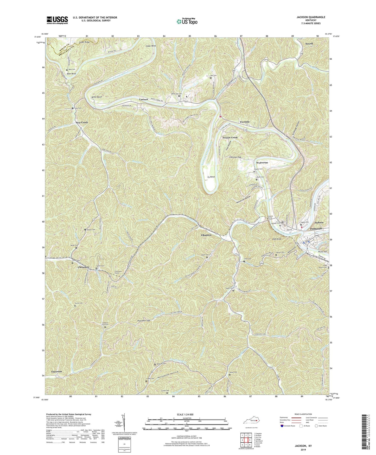
2022 topographic map quadrangle Jackson in the state of Kentucky. Scale: 1:24000. Based on the newly updated USGS 7.5' US Topo map series, this map is in the following counties: Breathitt, Wolfe. The map contains contour data, water features, and other items you are used to seeing on USGS maps, but also has updated roads and other features. This is the next generation of topographic maps. Printed on high-quality waterproof paper with UV fade-resistant inks.
Quads adjacent to this one:
West: Tallega
Northwest: Campton
North: Landsaw
Northeast: Lee City
East: Quicksand
Southeast: Haddix
South: Canoe
Southwest: Cowcreek
This map covers the same area as the classic USGS quad with code o37083e4.
Contains the following named places: Bailey Hollow, Bear Fork, Belcher Fork, Big Bridge Branch, Big Rock School, Blanche Haddix Church, Boone Fork, Breathitt County Sheriff's Office, Cane Creek, Cane Creek Church, Caney Fork, Cedar Bend, Cedar Creek, Chaney Cemetery, Chenowee, Chenowee Tunnel, Chestnut Gap, City of Jackson, Colts Fork, Combs Cemetery, Cope Fork, Cripple Creek, Cy Bend, Day Cemetery, Deaton Cemetery, Elkatawa, Eye Fork, Fivemile, Fivemile Church, Flat Hollow, Frozen Creek, Gabbard Flat Cemetery, Granny Branch, Griffith Branch, Gross Fork, Guerrant, Haddix Fork, Haddix Fork Church, Hagins Cemetery, Hayes Cemetery, Helton Cemetery, High Knob, High Top Church, Highland School, Holly Creek, Hollybush Hollow, Hurricane Branch, Jackson, Jackson Cemetery, Jackson Division, Jackson Fire Department, Jackson Police Department, Jackson Post Office, Jerry Fork, Kentucky Mountain Bible Institute, Kings Branch Cemetery, Lawson, Left Fork White Oak Creek, Lindon Branch, Lindon Fork, Little Cemetery, Mill Branch, Mill Creek, Miller Bend, Miller Branch, Miller Cemetery, Mount Carmel School, O and K Tunnel, Oakdale Cemetery, Oakdale Division, Panbowl Lake, Panhandle, Pasture Branch, Puncheon Gap, Right Fork White Oak Creek, Road Fork, Robinson Fork, Rose Bend, Rose Cemetery, Salyor Cemetery, Shacks Branch, Shoulderblade Church, Spencer Cemetery, Spicer Church, Spicewood Fork, Spring Branch, Stillhouse Hollow, Stray Branch School, Talent Cemetery, The Cutoff, Town Branch, Trace Fork, Trent Cemetery, Turkey Branch, Turner Cemetery, Tyra Branch, Vancleve School, Vancleve Volunteer Fire Department, Vires Fork, War Creek, War Shoal Branch, WEKG-AM (Jackson), White Oak Cemetery, White Oak Creek, WJSN-FM (Jackson), WMTC-AM (Vancleve), WMTC-FM (Vancleve), Wolverine, Wolverine Hollow