MyTopo
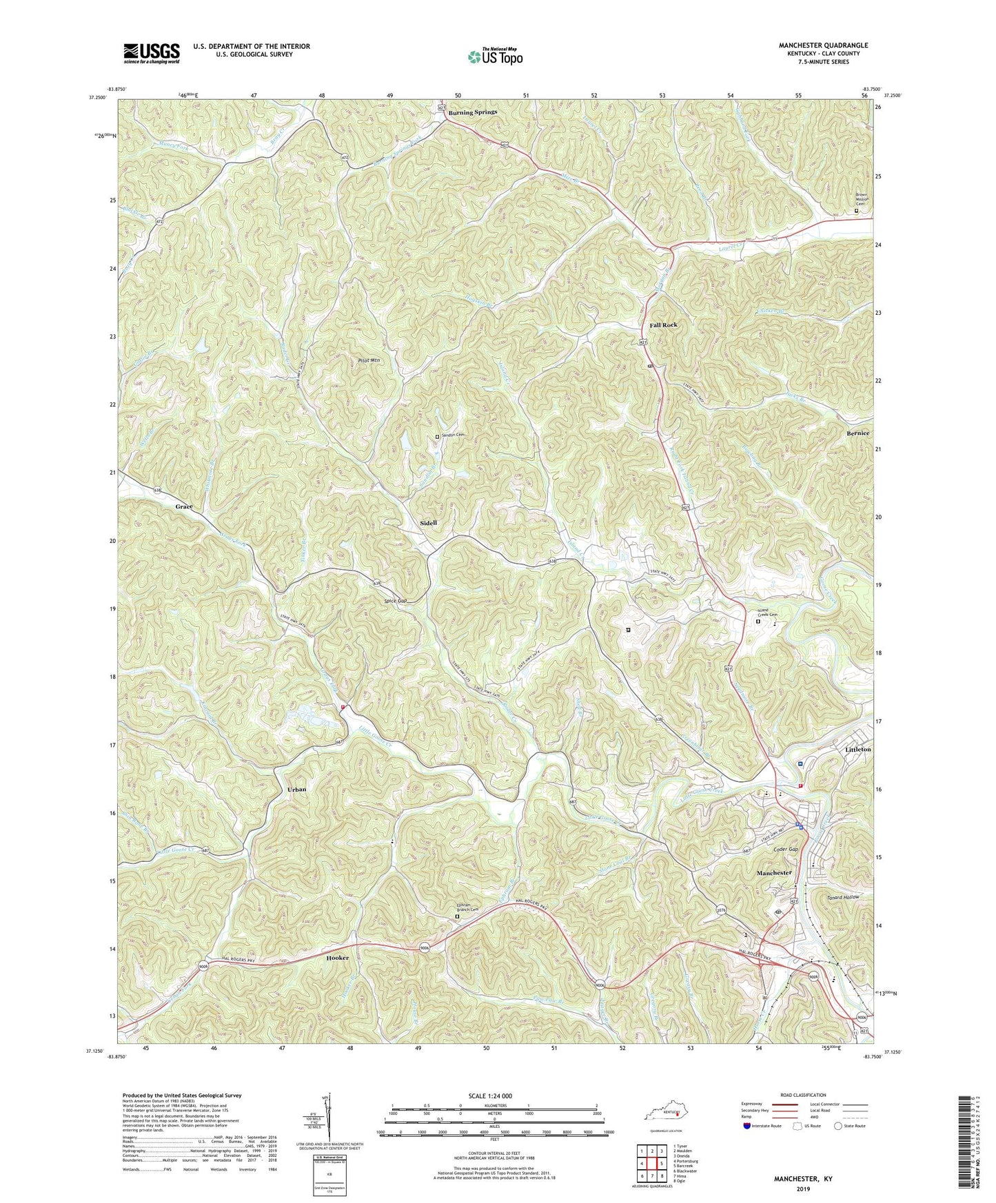
Manchester Kentucky US Topo Map
Couldn't load pickup availability
Also explore the Manchester Forest Service Topo of this same quad for updated USFS data
2022 topographic map quadrangle Manchester in the state of Kentucky. Scale: 1:24000. Based on the newly updated USGS 7.5' US Topo map series, this map is in the following counties: Clay. The map contains contour data, water features, and other items you are used to seeing on USGS maps, but also has updated roads and other features. This is the next generation of topographic maps. Printed on high-quality waterproof paper with UV fade-resistant inks.
Quads adjacent to this one:
West: Portersburg
Northwest: Tyner
North: Maulden
Northeast: Oneida
East: Barcreek
Southeast: Ogle
South: Hima
Southwest: Blackwater
This map covers the same area as the classic USGS quad with code o37083b7.
Contains the following named places: Add Post Office, Add School, Advent Health Manchester Hospital, Bernice, Bernice Post Office, Bethany Chapel, Blackie Branch, Bowling Branch, Brown Mission Cemetery, Brown Mission School, Buck Branch, Buffalo Salt Lick, Burning Springs, Burning Springs Division, Caution Post Office, City of Manchester, Clay County Emergency Ambulance Service, Clay County High School, Clay County Sheriff's Office, Clay County Vocational School, Coder Gap, East Manchester Post Office, Ephram Branch, Ephram Branch Cemetery, Fall Rock, Fall Rock Post Office, Federal Correctional Institution Manchester, Finley Railroad Station, Flatwoods, Gabbard Fork, Garrard Church, Gault Railroad Station, Gillian Ford, Grace, Grace Post Office, Gray Fork, Grays Fork, Grays Fork Church, Greenbriar Branch, Greenbriar Presbyterian Church, Greenbriar School, Hacker Fire and Rescue Department, Hacker School, Herron Railroad Station, Hogskin Branch, Hogskin School, Hollingsworth Post Office, Hooker, Hooker Branch, Hooker Post Office, Hooker School, Horse Creek, Horse Creek Railroad Junction, Island Creek, Island Creek Cemetery, Island Creek Church, Island Creek School, Kincaid Branch, Laurel Creek School, Laurel Railroad Station, Lee Railroad Station, Liberty Church, Little Goose Baptist Church, Little Goose Creek, Littleton, Littleton Census Designated Place, Lovers Leap, Lower Rader School, Macedonia Church, Manchester, Manchester Fire Department, Manchester Memorial Gardens, Manchester Police Department, Manchester Post Office, Manchester School, Mission of Mercy Church, Mize Branch, Morgan Branch, Morgan Branch Church, Muddy Gap Church, Muncy Fork, Muncy School, Murray School, Murry, Needmore Branch, Paces Creek, Paces Creek Elementary School, Pilot Mountain, Pine Grove Church, Pinhook Church, Pinhook School, Pleasant Run Church, Pleasant Valley, Ponder Post Office, Potters Chapel, Radder Lookout Tower, Rader Creek, Reed Branch, Right Fork Island Creek, Rock Gap Branch, Rock Gap School, Sacker Gap Post Office, Saint Anns Church, Sandlin Branch, Sandlin Cemetery, Shed Branch, Shin Bone Branch, Sidell, Sidell Post Office, Slick Rock School, Sourwood Post Office, South Manchester Railroad Station, Spice Gap, Stone Coal Branch, Tanard Hollow, Tanyard Branch, Tanyard School, Tinker Branch, Tinker Post Office, Union Salt Works, Upper Rader School, Urban, Urban Fork, Urban Post Office, Urban School, Wells Branch, Whitmore Branch, WKLB-AM (Manchester), WTBK-FM (Manchester), WWXL-AM (Manchester), WWXL-FM (Manchester), Yeager Branch, Zion Church