MyTopo
Maysville West Kentucky US Topo Map
Couldn't load pickup availability
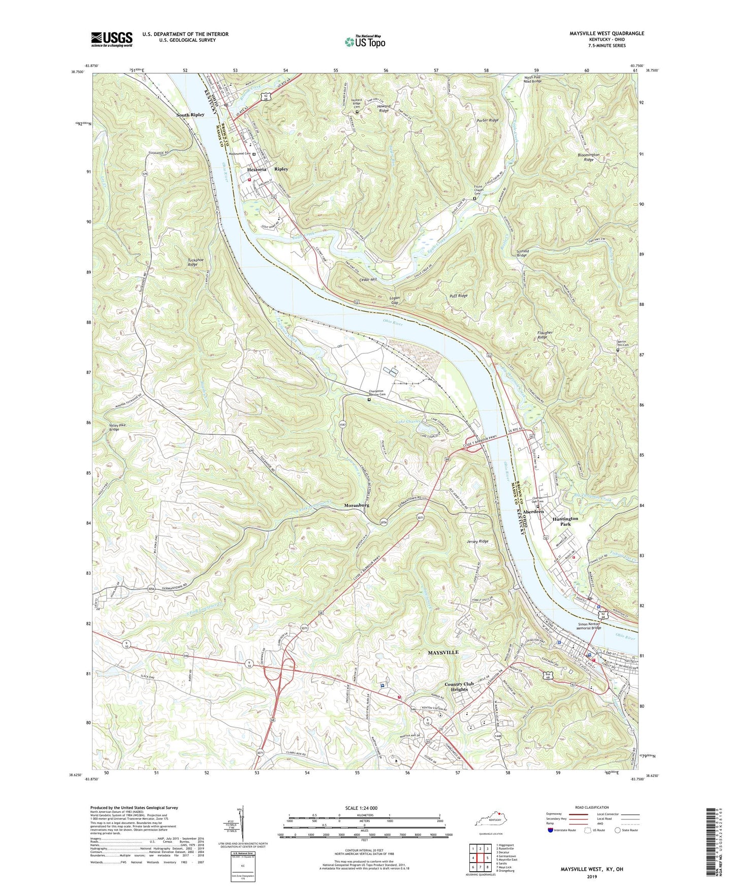
2022 topographic map quadrangle Maysville West in the states of Kentucky, Ohio. Scale: 1:24000. Based on the newly updated USGS 7.5' US Topo map series, this map is in the following counties: Mason, Brown. The map contains contour data, water features, and other items you are used to seeing on USGS maps, but also has updated roads and other features. This is the next generation of topographic maps. Printed on high-quality waterproof paper with UV fade-resistant inks.
Quads adjacent to this one:
West: Germantown
Northwest: Higginsport
North: Russellville
Northeast: Decatur
East: Maysville East
Southeast: Orangeburg
South: Mays Lick
Southwest: Sardis
Contains the following named places: Aberdeen, Aberdeen Community Park, Aberdeen Elementary School, Aberdeen Huntington Township Fire Department, Aberdeen Police Department, Aberdeen Post Office, Alanant-O-Wamiowee Historical Marker, Baylor Run, Beasley Creek, Beetle Creek, Big Threemile Creek, Bloomington Ridge, Brashears Railroad Station, Buckeye School, Carolyns Mini Room Museum, Cedar Hill, Centenary Methodist Church, Charleston Bottom Cemetery, Charlestown Bar, Charter Oak Cemetery, Church of Christ, Church of the Nazarene, City of Maysville, Clems Shady Nook Park, Country Club Heights, County High School, Downing School Number Twenty-nine, Eagle Creek, East Ripley, Elisha Green Historical Marker, Fernleaf Highland Volunteer Fire Department, First Baptist Church, First Southern Baptist Church, Fishing Gut Creek, Fitch School, Fitchs Chapel Cemetery, Flaugher Ridge, Flaugher School, Ghost Hollow, H E Pogue Distillery Company Historical Marker, Hamilton Landing, Hestoria, Howard Post Office, Howard Ridge, Howard Ridge Cemetery, Huntington Park, Jersey Ridge, Jersey Ridge School, John Colter Historical Marker, Kenton Station Golf Course, Kirker Landing, Lake Charles, Lawrence Creek, Lawrence Creek Christian Church, Lewis Collins Historical Marker, Limestone Creek, Limestone Historical Marker, Limestone Landing, Logan Gap, Maplewood Cemetery, Martin Hill Cemetery, Mason County Historical Marker, Mason County Sheriff's Office, Mason County Spy Company Historical Marker, Maysville - Mason County Ambulance Service, Maysville Academy Historical Marker, Maysville Community and Technical College, Maysville Country Club, Maysville Fire Department, Maysville Fire Department Station 2, Maysville Police Department, Maysville Post Office, Maysville Road Historical Marker, Meadowview Regional Medical Center, Moranburg, North Pole Road Bridge, Ohio Tobacco Museum, Old Stone Church, Phister's Landing, Poors Landing, Porter Hollow, Porter Ridge, Puff Ridge, Redoak Creek, Richard Collins Historical Marker, Ripley, Ripley Elementary School, Ripley Fire Department, Ripley First Presbyterian Church, Ripley Historic District, Ripley Life Squad, Ripley Museum, Ripley Post Office, Ripley-Union-Lewis High School, Rosemary Clooney Historical Marker, Saint Michaels Catholic Church, School Number Thirty-one, Scofield Bridge, Shawnee Hill, Sheltons Landing, Simon Kenton Acres, Simon Kenton Memorial Bridge, Simon Kentons Station Historical Marker, Slack Post Office, Slickaway Run, South Fork Lawrence Creek, South Ripley, South Ripley Railroad Station, Stanley F Reed Historical Marker, Stephenson School, Stevensons Landing, Tuckahoe Post Office, Tuckahoe Ridge, Tyler Airport, Union Township Public Library, Valley Pike Bridge, Village of Aberdeen, Village of Ripley, Wald Park, Warren Smith Trailer Park, WFTM-AM (Maysville), WFTM-FM (Maysville), William G Kenton Historical Marker