MyTopo
Prairieville Louisiana US Topo Map
Couldn't load pickup availability
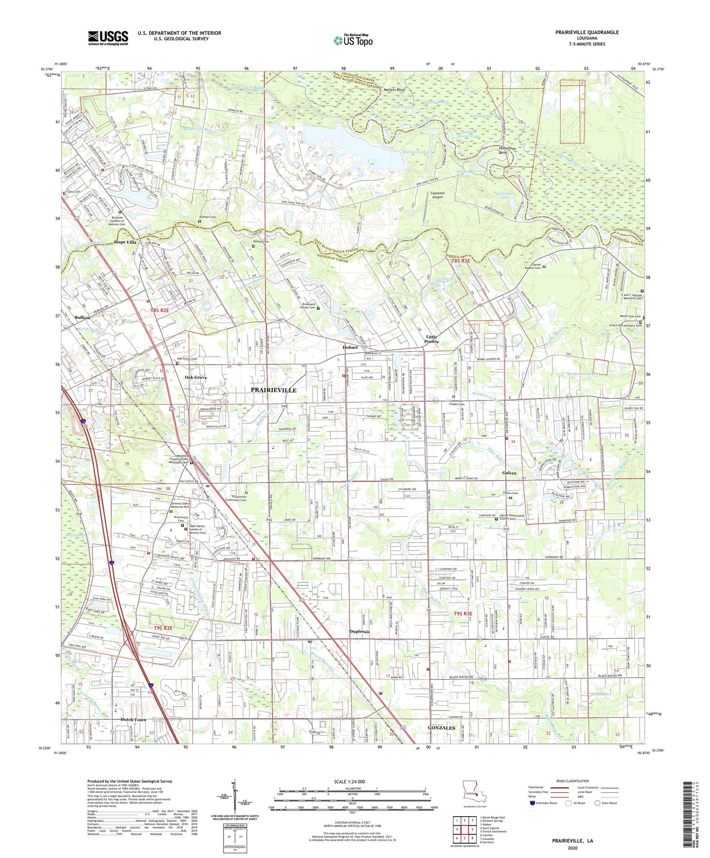
2020 topographic map quadrangle Prairieville in the state of Louisiana. Scale: 1:24000. Based on the newly updated USGS 7.5' US Topo map series, this map is in the following counties: Ascension, East Baton Rouge, Livingston. The map contains contour data, water features, and other items you are used to seeing on USGS maps, but also has updated roads and other features. This is the next generation of topographic maps. Printed on high-quality waterproof paper with UV fade-resistant inks.
Quads adjacent to this one:
West: Saint Gabriel
Northwest: Baton Rouge East
North: Denham Springs
Northeast: Walker
East: French Settlement
Southeast: Sorrento
South: Gonzales
Southwest: Carville
Contains the following named places: A Tale of Two Sisters Day Care Center, Airline Highway Parish Park, Ascension Baptist Church, Ascension Christian Academy, Ascension Christian Assembly, Ascension Church, Ascension Parish Fire Protection District 1 Headquarters, Ascension Parish Head Start Geismer School, Ascension Parish Head Start Prairieville School, Ascension Parish Library Galvez Branch, Ascension Wastewater Treatment Facility at Villa Galvez, Assembly of God Church, Bayou Manchac, Boggy Cut Bayou, Broussard Grove Baptist Church, Broussard Grove Church, Bullion, Cann Cemetery, Capozzoli Airport, Carpenter Chapel, Carpenter Church, Celebration of Christ Church, Central Baptist Church, Central Middle School, Clay Cut Bayou, Comeaux Mobile Park, Cotton Bayou, Don Babin Airport, Duplessis, Duplessis Post Office, Duplessis Primary School, Dutch Town, Dutchtown Baptist Church, Dutchtown High School, Dutchtown Middle School, Dutchtown Primary School, Elliot Acres, Evan Airport, Fellowship Church, Ficklin Cemetery, Ficklin Lake, First Assembly of God Church, Galvez, Galvez - Lake Fire Department Station 50, Galvez Baptist Church, Galvez Middle School, Galvez Pentecostal Church, Galvez Primary School, Galvez Town, Gonzales Oil Field, Gospel Lighthouse Church, Hillman Cemetery, Hobart, Hoo Shoo Too Club, Hope Villa, Hopeville, Horseshoe Bend, Horseshoe Lake, Jim Bayou, Johnson Bayou, Landry's Mobile Home Park, Le Chateau Des Jeunes, Little Prairie, Little Prairie Baptist Church, Little Prairie Gas Field, Mallets Bluff, Mallets Bluff Oil Field, Manchac Parish Park, Meadows Chapel Methodist Church, Melton Lake, Mount Gillion Church, Mount Zion Baptist Church, Mount Zion Cemetery, Muddy Creek, Myford Cemetery, New Light Church, Oak Grove, Oak Grove Baptist Church, Oak Grove Primary School, Ochsner Health Center Prairieville, Parish Governing Authority District 11, Parish Governing Authority District 4, Parish Governing Authority District 5, Parish Governing Authority District 7, Parish Governing Authority District 8, Paula Park, Pecan Cove, Pecan Creek, Prairieville, Prairieville Census Designated Place, Prairieville Fire Department Station 31, Prairieville Fire Department Station 32, Prairieville Middle School, Prairieville Park, Prairieville Post Office, Prairieville Primary School, Prairieville Volunteer Fire Department Station 30, Raybons Village Mobile Home Park, Redman Junior Lake, Redman Lake, Richards Gardens of Memory Cemetery, Roddy Bayou, Rosenwald School, S and H Mobile Home Park, Saint George Fire Department Station 64, Saint John the Evangelist Church, Saint John the Evangelist School, Saint Mark Catholic Church, Saint Paul Church, Sawpit Landing, Seventh District Fire Department Substation 71, Shady Oaks Mobile Home Park, Sides Bayou, Southwood Park, Southwood Village Wastewater Treatment Facility, Sportsman Lake, Stevens Park, Truelight Baptist Church, Truelight Church, Twin Lakes Mobile Estates, Twin Oaks Mobile Home Park, Universal Church, Ward Eight, Ward Nine, Welsh Gully, WSLG Radio Towers, WSLG-AM (Gonzales), ZIP Code: 70769