MyTopo
Blue Hill Maine US Topo Map
Couldn't load pickup availability
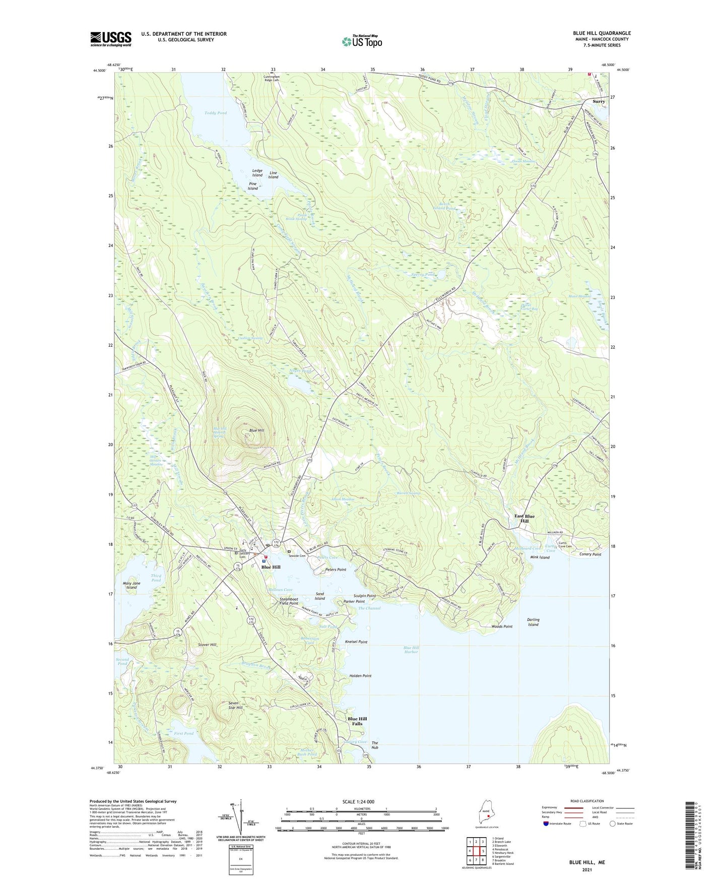
2024 topographic map quadrangle Blue Hill in the state of Maine. Scale: 1:24000. Based on the newly updated USGS 7.5' US Topo map series, this map is in the following counties: Hancock. The map contains contour data, water features, and other items you are used to seeing on USGS maps, but also has updated roads and other features. This is the next generation of topographic maps. Printed on high-quality waterproof paper with UV fade-resistant inks.
Quads adjacent to this one:
West: Penobscot
Northwest: Orland
North: Branch Lake
Northeast: Ellsworth
East: Newbury Neck
Southeast: Bartlett Island
South: Brooklin
Southwest: Sargentville
This map covers the same area as the classic USGS quad with code o44068d5.
Contains the following named places: Albion Meadow, Bagaduce Music Lending Library, Beech Island Pond, Blue Hill, Blue Hill Airport, Blue Hill Census Designated Place, Blue Hill Congregational Church, Blue Hill Consolidated School, Blue Hill Country Club, Blue Hill Fairground, Blue Hill Falls, Blue Hill Harbor, Blue Hill Harbor School, Blue Hill Historic District, Blue Hill Memorial Hospital, Blue Hill Mineral Spring, Blue Hill Post Office, Blue Hill Public Library, Blue Hill Town Wharf, Blue Hill Trail, Blue Hill Volunteer Fire Department, Bragdon Brook, Burrett Swamp, Camp Field Stream, Canary Cove, Carleton Stream, Conary Point, Curtis Cove, Curtis Cove Cemetery, Cushion Swamp, Daniel Carter Bog, Darling Island, Early Settlers Cemetery, East Blue Hill, East Blue Hill Public Library, Eddie Brook, First Baptist Church of Blue Hill, Flood Stream, Floods Meadow, George Stevens Academy, Holden Point, Kneisel Point, Kollegewidgwok Yacht Club, Ledge Island, Line Island, Little Peters Brook, Mann Meadow, Mary Jane Island, McHeard Brook, McHeard Cove, Meadow Stream, Mellows Cove, Mill Stream, Mill Stream Meadow, Mink Island, Mother Bush Pond, Noyes Pond, Parker Point, Peninsula Ambulance Corps, Peters Brook, Peters Cove, Peters Point, Pine Island, Puzzle Brook, Puzzle Brook Swamp, Robertson Cove, Salt Pond, Sand Island, Sandy Brook, Sculpin Point, Seaside Cemetery, Seven Star Hill, Sperry Pond, Steamboat Field Point, Stover Hill, Surry, Surry Elementary School, Surry United Methodist Church, Surry Volunteer Fire Department, The Bay School, The Channel, The Nub, Third Pond, Town of Blue Hill, Town of Surry, WERU-FM (Blue Hill), Western Brook, Wills Brook, Woods Point, ZIP Codes: 04614, 04629, 04684