MyTopo
Castine Maine US Topo Map
Couldn't load pickup availability
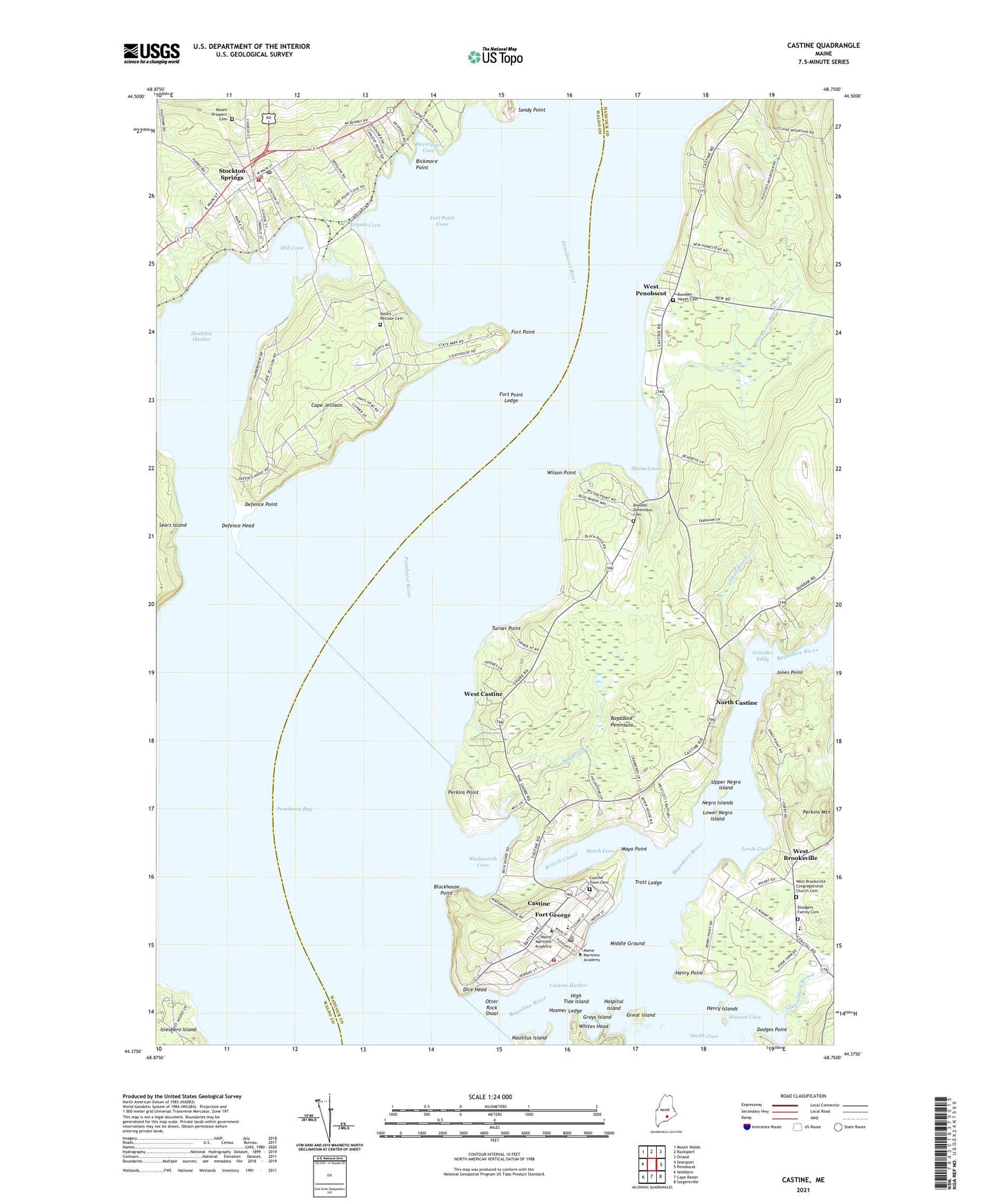
2024 topographic map quadrangle Castine in the state of Maine. Scale: 1:24000. Based on the newly updated USGS 7.5' US Topo map series, this map is in the following counties: Hancock, Waldo. The map contains contour data, water features, and other items you are used to seeing on USGS maps, but also has updated roads and other features. This is the next generation of topographic maps. Printed on high-quality waterproof paper with UV fade-resistant inks.
Quads adjacent to this one:
West: Searsport
Northwest: Mount Waldo
North: Bucksport
Northeast: Orland
East: Penobscot
Southeast: Sargentville
South: Cape Rosier
Southwest: Islesboro
This map covers the same area as the classic USGS quad with code o44068d7.
Contains the following named places: Adams School, Andrews Hall, Bagaduce Peninsula, Bagaduce Volunteer Ambulance Corps, Bath Iron Works Center for Advanced Technology, Bethany Chapel, Bickmore Point, Blockhouse Point, Blodgett Family Cemetery, Bog Brook, Bowden Devereaux Cemetery, British Canal, Brooksville Elementary School, Cape Jellison, Captain Quick Alumni Hall, Cary W Bok Swimming Pool, Castine, Castine Census Designated Place, Castine Community Hospital, Castine Fire Rescue Department, Castine Golf Club, Castine Harbor, Castine Historic District, Castine Post Office, Castine Town Cemetery, Castine Town Dock, Castine Unitarian Church, Castine Yacht Club, Clements Brook, Curtis Hall, Defence Head, Defence Point, Delano Auditorium, Devereaux Cove, Dice Head, Dice Head Light, Dismukes Hall, Dodges Point, Emerson School, Farnham School, Fort George, Fort Madison, Fort Point, Fort Point Cove, Fort Point Ledge, Fort Point State Park, Graduate Commons, Grants Cove, Grays Island, Great Island, Grindles Eddy, Hatch Cove, Henry Islands, Henry Point, High Tide Island, Hosmer Ledge, Hospital Island, Jones Point, LEavitt Hall, Lords Cove, Lower Negro Island, Maine Maritime Academy, Maine Maritime Academy Nutting Memorial Library, Margaret Chase Smith Gymnasium, Mayo Point, Middle Ground, Mill Cove, Mill Pond, Morse Cove, Mount Prospect Cemetery, Negro Islands, North Castine, Oakley Logan Alexander Fieldhouse, Otter Rock Shoal, Payson Hall, Penobscot, Penobscot River, Perkins House, Perkins Mountain, Perkins Point, Pilot House, Platz Hall, Presidents House, Ritchie Field, Rodgers Hall, Sandy Point, Shepardson Brook, Smell Brook, Stockton Harbor, Stockton Springs, Stockton Springs Community Library, Stockton Springs Elementary School, Stockton Springs Post Office, Stockton Springs Volunteer Ambulance Service, Stockton Springs Volunteer Fire Department, Town of Castine, Town of Stockton Springs, Trinity Church, Trott Ledge, Turner Point, Upper Negro Island, Wadsworth Cove, Wasson Cove, West Brooksville, West Brooksville Congregational Church Cemetery, West Castine, West Penobscot, Whites Head, Wilson Point, Witherle Memorial Library, Witherle Park, ZIP Code: 04421