MyTopo
Bucksport Maine US Topo Map
Couldn't load pickup availability
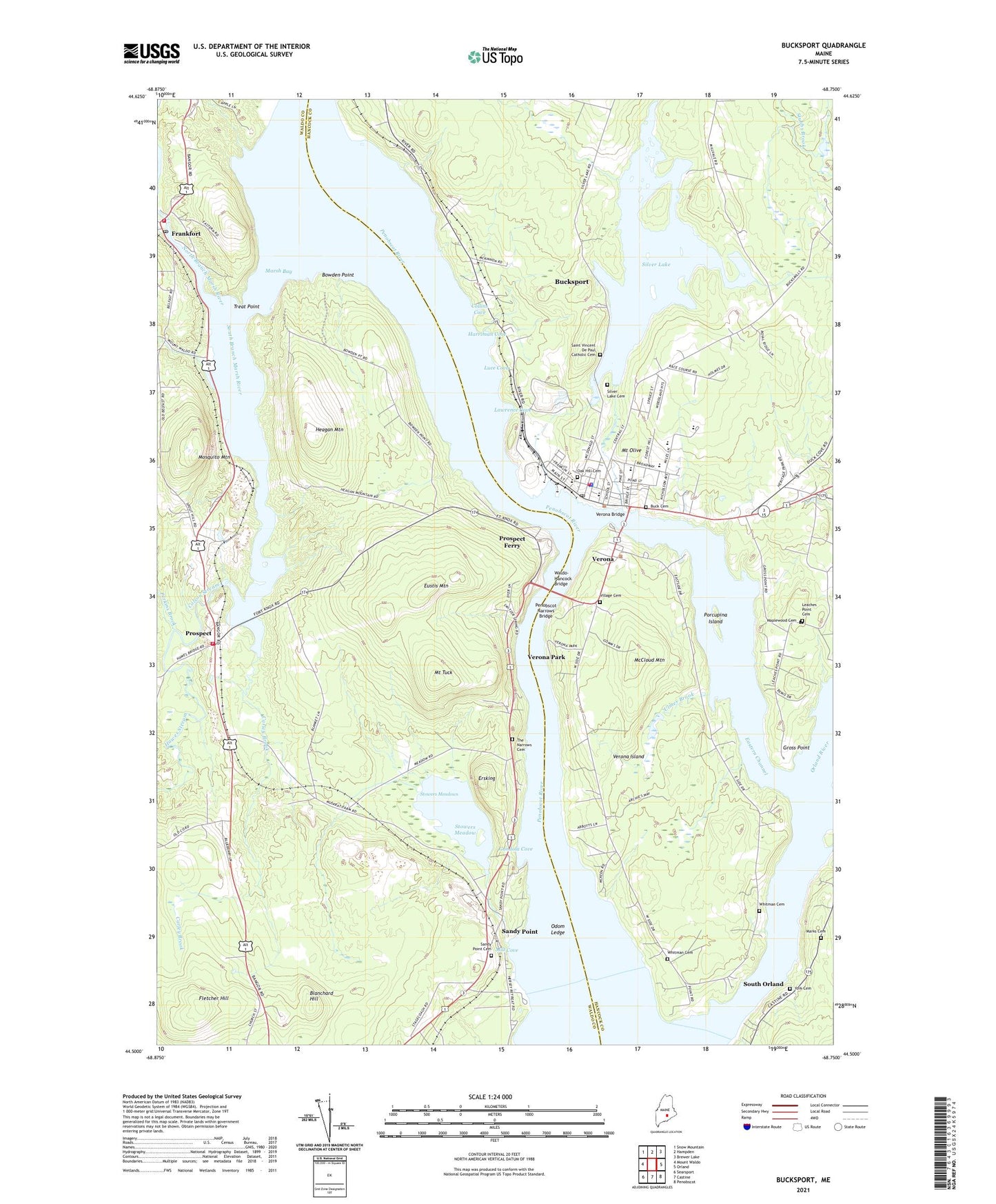
2024 topographic map quadrangle Bucksport in the state of Maine. Scale: 1:24000. Based on the newly updated USGS 7.5' US Topo map series, this map is in the following counties: Waldo, Hancock. The map contains contour data, water features, and other items you are used to seeing on USGS maps, but also has updated roads and other features. This is the next generation of topographic maps. Printed on high-quality waterproof paper with UV fade-resistant inks.
Quads adjacent to this one:
West: Mount Waldo
Northwest: Snow Mountain
North: Hampden
Northeast: Brewer Lake
East: Orland
Southeast: Penobscot
South: Castine
Southwest: Searsport
This map covers the same area as the classic USGS quad with code o44068e7.
Contains the following named places: Blanchard Hill, Bowden Point, Buck Cemetery, Buck Memorial Library, Bucksport, Bucksport Census Designated Place, Bucksport Fire Station and Emergency Medical Department, Bucksport High School, Bucksport Historical Society Museum, Bucksport Middle School, Bucksport Police Department, Bucksport Post Office, Carley Brook, Collins Cove, Colson Stream, Eastern Channel, Eastern Maine Conference Seminary, Elm Street Congregational Church, Ersking, Eustis Mountain, Evangel Baptist Academy, Evangelical Baptist Church, Fletcher Hill, Fort Knox State Historic Site, Frankfort Post Office, Frankfort Volunteer Village Fire Station, G Herbert Jewett Elementary School, Gondola Cove, Gross Point, Harriman Cove, Hawes Stream, Heagan Mountain, Lawrence Cove, Leaches Point Cemetery, Luce Cove, Maplewood Cemetery, Marks Cemetery, Marsh Bay, Marsh River Dam, Marsh Stream, Marsh Stream Reservoir, McCloud Mountain, Miles Lane Elementary School, Mill Cove, Mosquito Mountain, Mount Olive, Mount Tuck, North Branch Marsh River, Northeast Historic Film Library, Oak Hill Cemetery, Odom Ledge, Orland River, Penobscot Narrows Bridge, Penobscot Narrows Observatory, Perkins Brook, Porcupina Island, Prospect, Prospect Ferry, Prospect Volunteer Fire Station, Reach High School, Sandy Point, Sandy Point Game Management Area, Sandy Point Post Office, Silver Lake, Silver Lake Cemetery, Silver Lake Dam, South Branch Marsh River, South Orland, Stowers Meadow, Stowers Meadow Dam, Stowers Meadows, The Flying Dutchman Campground, Town of Prospect, Town of Verona Island, Treat Point, Ulmer Brook, Verona, Verona Bridge, Verona Island, Verona Park, Village Cemetery, Waldo Peirce Reading Room and Library, Waldo-Hancock Bridge, Walter H Gardner Middle School, Whitman Cemetery, York Cemetery, ZIP Code: 04981