MyTopo
Deer Isle Maine US Topo Map
Couldn't load pickup availability
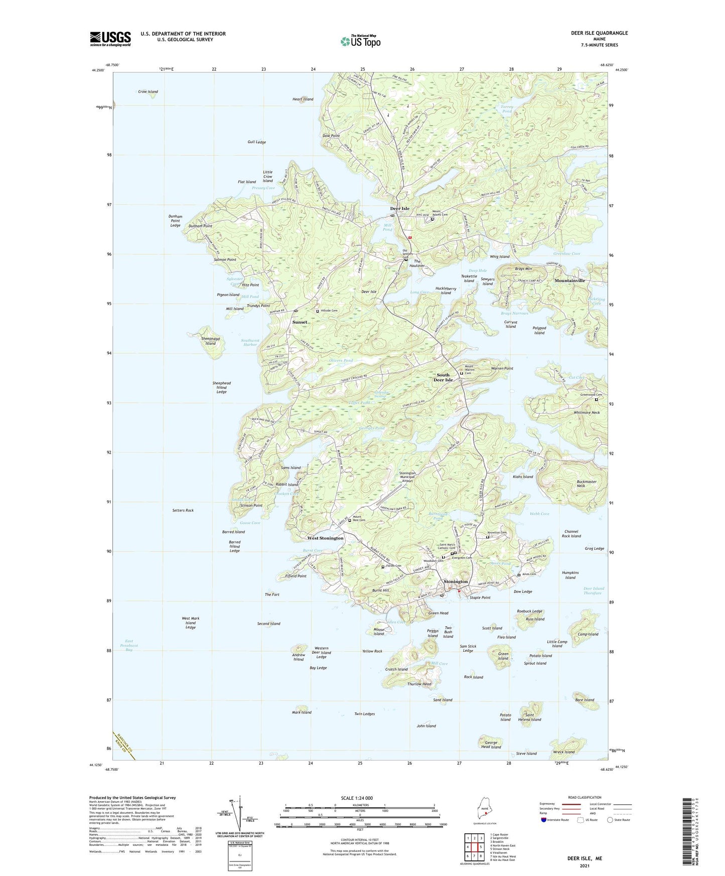
2024 topographic map quadrangle Deer Isle in the state of Maine. Scale: 1:24000. Based on the newly updated USGS 7.5' US Topo map series, this map is in the following counties: Hancock, Knox. The map contains contour data, water features, and other items you are used to seeing on USGS maps, but also has updated roads and other features. This is the next generation of topographic maps. Printed on high-quality waterproof paper with UV fade-resistant inks.
Quads adjacent to this one:
West: North Haven East
Northwest: Cape Rosier
North: Sargentville
Northeast: Brooklin
East: Stinson Neck
Southeast: Isle Au Haut East
South: Isle Au Haut West
Southwest: Vinalhaven
This map covers the same area as the classic USGS quad with code o44068b6.
Contains the following named places: Advent Christian Fellowship Church, Allen Cove, Ames Cemetery, Ames Pond, Andrew Island, Bare Island, Barred Island, Barred Island Ledge, Barred Island Preserve, Bay Ledge, Brays Mountain, Brays Narrows, Buckmaster Neck, Burnt Cove, Burnt Hill, Burntland Pond, Camp Island, Cat Cove, Channel Rock Island, Chase Emerson Memorial Library, Crockett Cove, Crockett Cove Woods, Crockett Cove Woods Preserve, Crotch Island, Crow Island, Current Island, Deep Hole, Deer Island Thorofare Light Station, Deer Isle, Deer Isle - Stonington High School, Deer Isle Post Office, Deer Isle Stonington Elementary School, Deer Isle Volunteer Fire Department, Dow Ledge, Dow Point, Dunham Point, Dunham Point Ledge, East Penobscot Bay, Fifield Point, Flat Island, Flea Island, Forest Cemetery, Galilean Gospel Temple, George Head Island, Georges Pond, Goose Cove, Green Head, Green Island, Greenlaw Cove, Greenwood Cemetery, Grog Ledge, Gull Ledge, Heart Island, Hillside Cemetery, Hitz Point, Holt Pond, Huckleberry Island, Humpkins Island, Inner Harbor, John Island, John L Goss Quarry, Kiahs Island, Knowlton Cemetery, Labrador Swamp, Lily Pond, Lily Pond Dam, Little Camp Island, Little Crow Island, Little George Head Island, Long Cove, Mark Island, Memorial Ambulance Corps, Mill Cove, Mill Island, Mill Pond, Moose Island, Mount Adams Cemetery, Mount Warren Cemetery, Mountainville, Northwest Harbor, Old Settlers Cemetery, Olivers Pond, Peggys Island, Pigeon Island, Polypod Island, Potato Island, Pressey Cove, Rabbit Island, Rock Island, Roebuck Ledge, Russ Island, Saint Helena Island, Salmon Point, Salome Sellers House Museum, Sam Stick Ledge, Sams Island, Sand Island, Sawyers Island, Scott Island, Scraggy Island, Second Island, Setters Rock, Settlement Quarry, Sheephead Island, Sheephead Island Ledge, Smalls Cove, South Deer Isle, Southeast Harbor, Southwest Harbor, Sprout Island, Staple Point, Steve Island, Stinson Point, Stonington, Stonington Elementary School, Stonington Methodist Church, Stonington Municipal Airport, Stonington Post Office, Stonington Public Library, Stonington Volunteer Fire Department, Sunset, Sunset Post Office, Sylvester Cove, Teakettle Island, The Fort, The Haulover, Thurlow Head, Toffet Pond, Toothacher Ledge, Torrey Pond, Town of Deer Isle, Town of Stonington, Trundys Point, Twin Ledges, Two Bush Island, Warren Point, Webb Cove, West Deer Isle, West Mark Island Ledge, West Stonington, Western Deer Island Ledge, Whig Island, Whitmore Neck, Wreck Island, Yellow Rock, ZIP Code: 04681