MyTopo
Stinson Neck Maine US Topo Map
Couldn't load pickup availability
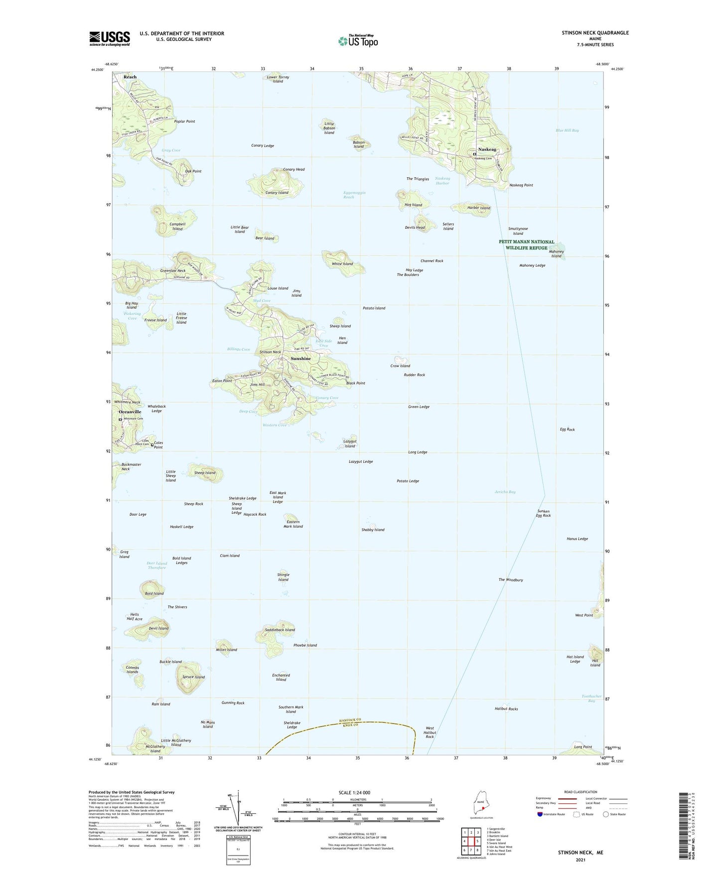
2024 topographic map quadrangle Stinson Neck in the state of Maine. Scale: 1:24000. Based on the newly updated USGS 7.5' US Topo map series, this map is in the following counties: Hancock, Knox. The map contains contour data, water features, and other items you are used to seeing on USGS maps, but also has updated roads and other features. This is the next generation of topographic maps. Printed on high-quality waterproof paper with UV fade-resistant inks.
Quads adjacent to this one:
West: Deer Isle
Northwest: Sargentville
North: Brooklin
Northeast: Bartlett Island
East: Swans Island
Southeast: Johns Island
South: Isle Au Haut East
Southwest: Isle Au Haut West
This map covers the same area as the classic USGS quad with code o44068b5.
Contains the following named places: Babson Island, Bear Island, Beth Eden Church, Big Hay Island, Billings Cove, Black Point, Bold Island, Bold Island Ledges, Buckle Island, Buckmaster Ledge, Campbell Island, Channel Rock, Clam Island, Coles Point, Coles Point Cemetery, Conary Cove, Conary Head, Conary Island, Conary Ledge, Coombs Islands, Coot Islands, Crow Island, Deep Cove, Deer Island Thorofare, Devil Island, Devils Head, Door Lege, East Mark Island Ledge, East Side Cove, Eastern Mark Island, Eaton Point, Egg Rock, Enchanted Island, Fish Creek, Freese Island, Gray Cove, Green Ledge, Greenlaw Neck, Grog Island, Gunning Rock, Halibut Rocks, Hanus Ledge, Harbor Island, Haskell Ledge, Hat Island, Hat Island Ledge, Hay Ledge, Haycock Rock, Haystack Mountain School of Crafts Library, Haystack Mountains School of Crafts, Hells Half Acre, Hen Island, Hog Island, Jericho Bay, Jims Hill, Jims Island, Lazygut Island, Lazygut Ledge, Little Babson Island, Little Bear Island, Little Freese Island, Little McGlathery Island, Little Sheep Island, Long Ledge, Long Point, Louse Island, Lower Torrey Island, Mahoney Island, Mahoney Ledge, Millet Island, Mud Cove, Naskeag, Naskeag Harbor, Naskeag Point, No Mans Island, Oak Point, Oceanville, Phoebe Island, Pickering Cove, Poplar Point, Potato Island, Potato Ledge, Ram Island, Reach, Rudder Rock, Saddleback Island, Sellers Island, Shabby Island, Sheep Island, Sheep Island Ledge, Sheep Rock, Sheldrake Ledge, Shingle Island, Smuttynose Island, Southern Mark Island, Spruce Island, Stinson Neck, Sunken Egg Rock, Sunshine, Sunshine Campground, The Boulders, The Shivers, The Triangles, The Woodbury, West Halibut Rock, West Point, Western Cove, Whaleback Ledge, White Island, Whitmore Cemetery, ZIP Code: 04627