MyTopo
Freeport Maine US Topo Map
Couldn't load pickup availability
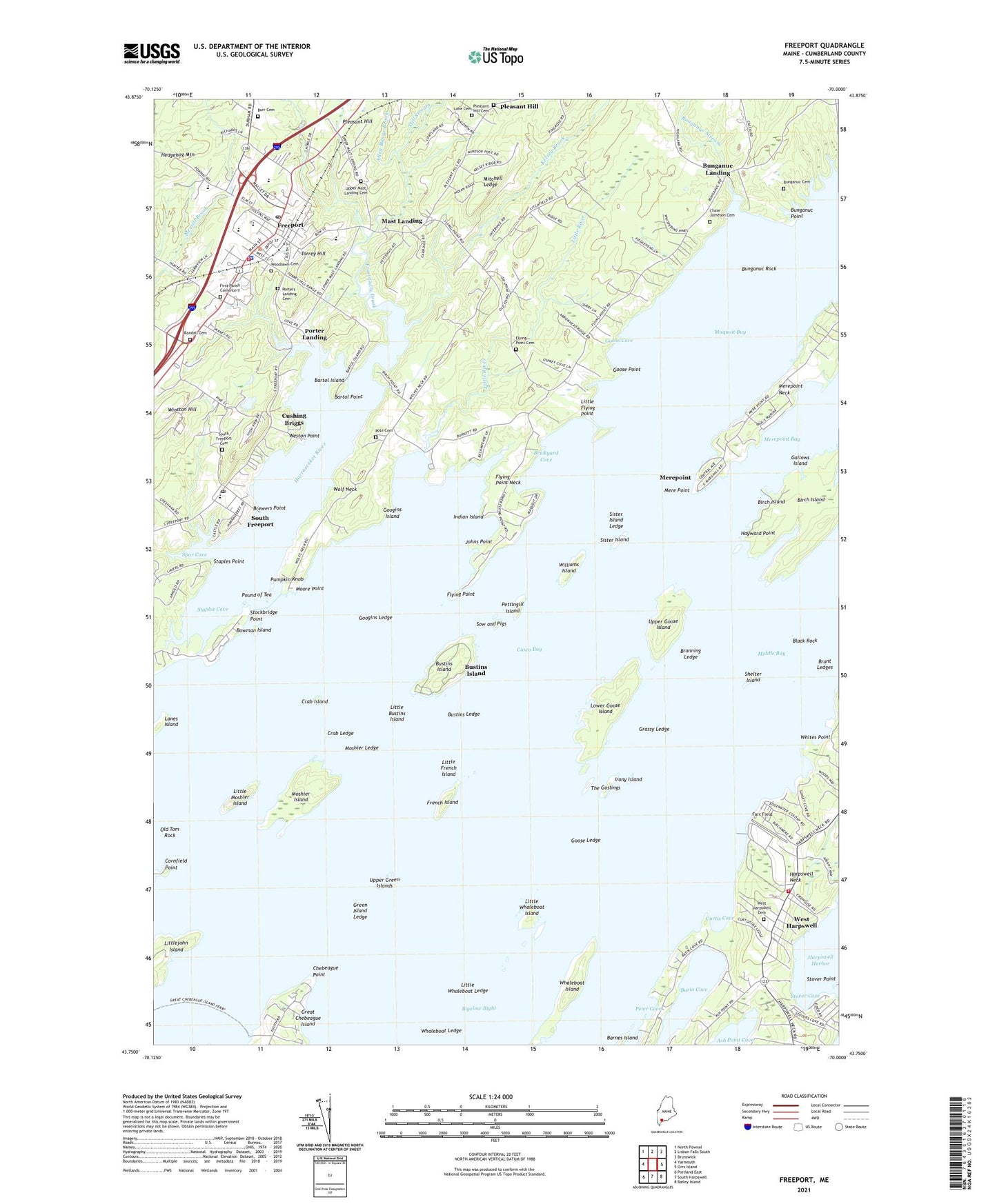
2021 topographic map quadrangle Freeport in the state of Maine. Scale: 1:24000. Based on the newly updated USGS 7.5' US Topo map series, this map is in the following counties: Cumberland. The map contains contour data, water features, and other items you are used to seeing on USGS maps, but also has updated roads and other features. This is the next generation of topographic maps. Printed on high-quality waterproof paper with UV fade-resistant inks.
Quads adjacent to this one:
West: Yarmouth
Northwest: North Pownal
North: Lisbon Falls South
Northeast: Brunswick
East: Orrs Island
Southeast: Bailey Island
South: South Harpswell
Southwest: Portland East
Contains the following named places: Allen Range Brook, Barnes Island, Bartol Island, Bartol Point, Basin Cove, Birch Island, Black Rock, Bowman Island, Branning Ledge, Brant Ledges, Brewers Point, Brewers South Freeport Marine, Brickyard Cove, Bunganuc Cemetery, Bunganuc Landing, Bunganuc Point, Bunganuc Rock, Bunganuc Stream, Burr Cemetery, Bustins Island, Bustins Ledge, Casco Castle, Castle Tower, Chase - Jameson Cemetery, Chebeague Point, Cornfield Point, Crab Island, Crab Ledge, Curtis Cove, Cushing Briggs, Environmental Building Center, Farr Field, First Baptist Church, First Parish Cementery, First Parish Congregational Church, Flying Point, Flying Point Cemetery, Flying Point Neck, Freeport, Freeport Census Designated Place, Freeport Community Library, Freeport Crossing Outlet Mall, Freeport Fire Rescue Department, Freeport High School, Freeport Middle School, Freeport Nursing and Rehabilitation Center, Freeport Outlet Shopping Center, Freeport Police Department, Freeport Post Office, Freeport Town Dock and Landing, Freeport Town Hall, Freeport Village Square Shopping Center, French Island, Frost Gully Brook, Gallows Island, Googins Island, Googins Ledge, Goose Cove, Goose Ledge, Goose Point, Grassy Ledge, Green Island Ledge, Harpswell Harbor, Harpswell Neck Fire and Rescue Irving F Chipman Station, Harraseeket Historic District, Harraseeket River, Harraseeket Yacht Club, Hayward Point, Indian Island, Irony Island, Johns Point, Kelsey Brook, King Way Mall Shopping Center, Lane Cemetery, L'Ecole Francaise du Maine School, Litchfields School, Little Bustins Island, Little Flying Point, Little French Island, Little Moshier Island, Little River, Little Whaleboat Island, Little Whaleboat Ledge, Lower Goose Island, Maine Classical School, Maquoit Bay, Mast Landing, Mast Landing Bird Sanctuary, Mast Landing School, Meadowbrook Montessori School, Mere Point, Merepoint, Merepoint Bay, Merepoint Yacht Club, Mill Stream, Mitchell Ledge, Moore Point, Morse Street School, Moshier Island, Moshier Ledge, Old Tom Rock, Peter Cove, Pettengill Farm Museum, Pettingill Island, Pine Tree Academy, Pleasant Hill, Pleasant Hill Cemetery, Pleasant Hill Chapel, Porter Landing, Porters Landing Cemetery, Pote Cemetery, Pound of Tea, Pumpkin Knob, Randall Cemetery, Saint Judes Catholic Church, Seaton School, Shelter Island, Sister Island, Sister Island Ledge, South Freeport, South Freeport Cemetery, South Freeport Church, South Freeport Post Office, Sow and Pigs, Spar Cove, Staples Cove, Staples Point, Stockbridge Point, Stover Cove, Strouts Point Marina, Strouts Point Wharf, The Goslings, Torrey Hill, Town of Freeport, Upper Goose Island, Upper Green Islands, Upper Mast Landing Cemetery, Village Square Information Center, West Harpswell, West Harpswell Cemetery, West Harpswell Elementary School, Weston Point, Whaleboat Island, Whaleboat Ledge, Whites Point, Williams Island, Winslow Memorial Park, Winston Hill, Wolf Neck, Wolfes Neck Woods State Park, Woodlawn Cemetery, ZIP Code: 04032