MyTopo
Friendship Maine US Topo Map
Couldn't load pickup availability
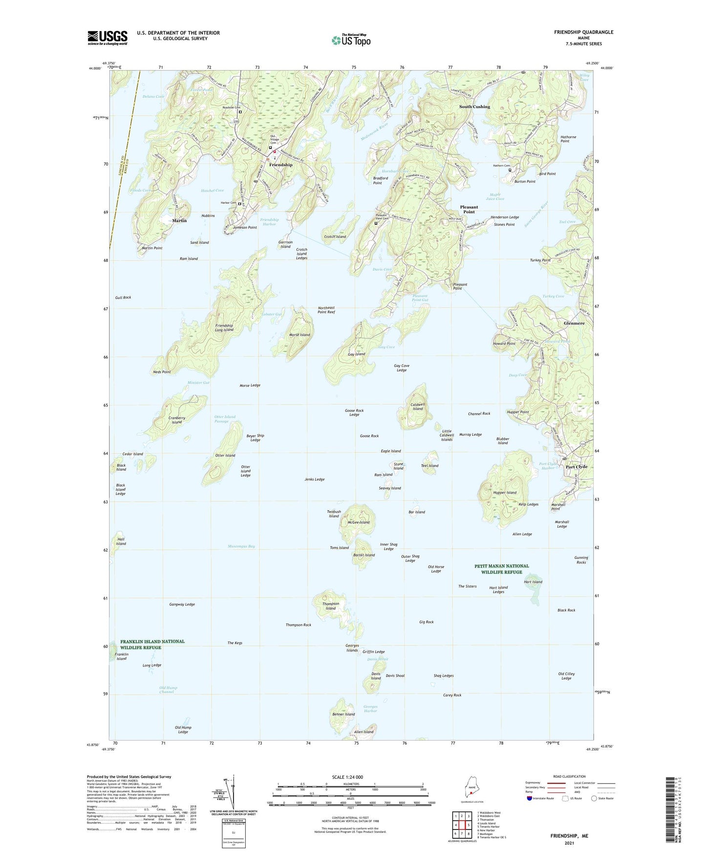
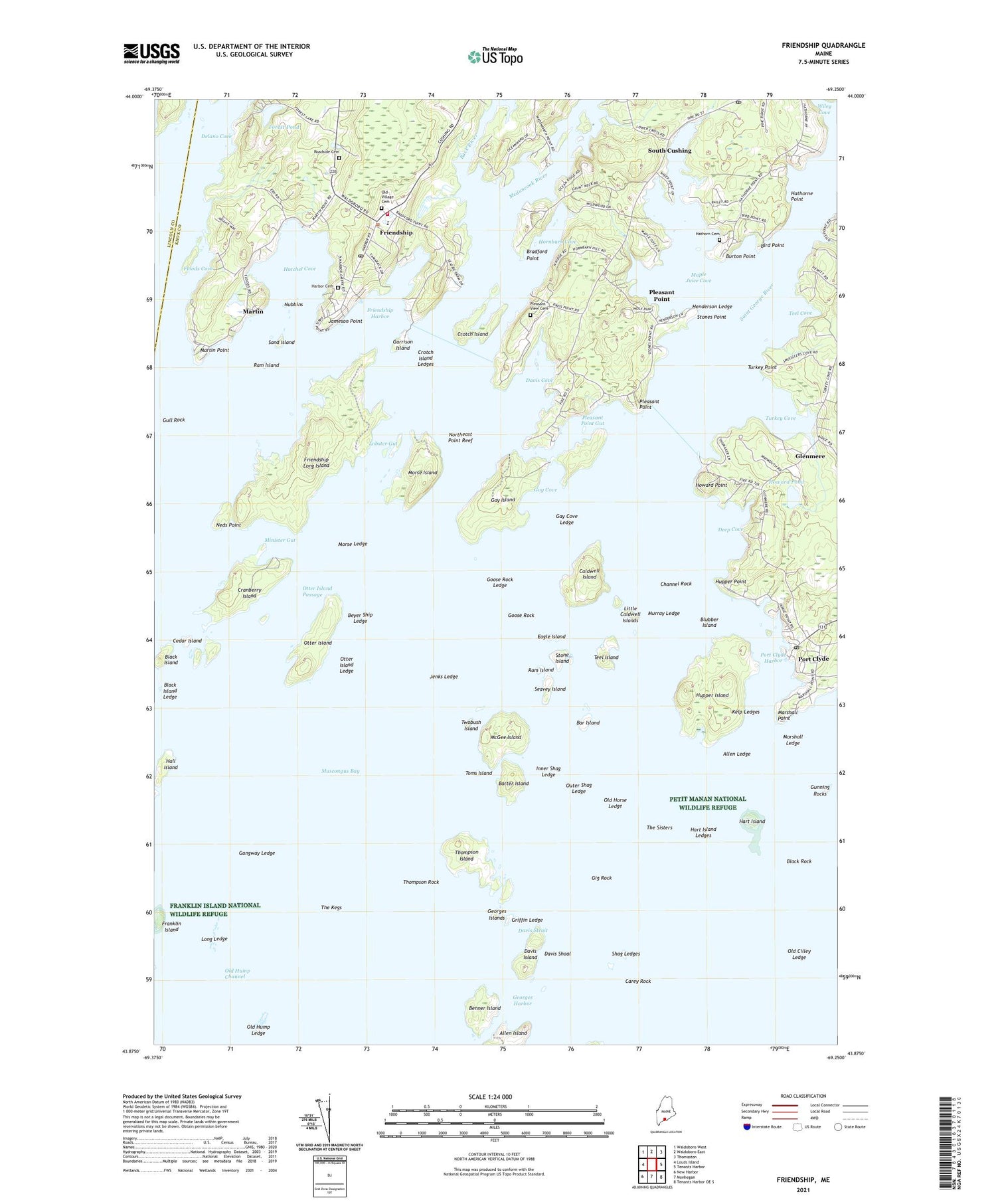
2021 topographic map quadrangle Friendship in the state of Maine. Scale: 1:24000. Based on the newly updated USGS 7.5' US Topo map series, this map is in the following counties: Knox, Lincoln. The map contains contour data, water features, and other items you are used to seeing on USGS maps, but also has updated roads and other features. This is the next generation of topographic maps. Printed on high-quality waterproof paper with UV fade-resistant inks.
Quads adjacent to this one:
West: Louds Island
Northwest: Waldoboro West
North: Waldoboro East
Northeast: Thomaston
East: Tenants Harbor
Southeast: Tenants Harbor OE S
South: Monhegan
Southwest: New Harbor
Contains the following named places: Allen Ledge, Back River, Bar Island, Barter Island, Benner Island, Beyer Ship Ledge, Bird Point, Black Island, Black Island Ledge, Black Rock, Blubber Island, Bradford Point, Burton Point, Caldwell Island, Carey Rock, Cedar Island, Channel Rock, Cranberry Island, Crotch Island, Crotch Island Ledges, Crystal Pond, Crystal Pond Dam, Cushing Post Office, Davis Cove, Davis Island, Davis Shoal, Davis Strait, Deep Cove, Delano Cove, Eagle Island, Floods Cove, Forest Pond, Forest Pond Dam, Franklin Island, Franklin Island National Wildlife Refuge, Friendship, Friendship Harbor, Friendship Long Island, Friendship Museum, Friendship Post Office, Friendship Public Library, Friendship Village School, Friendship Volunteer Fire Department, Gangway Ledge, Garrison Island, Gay Cove, Gay Cove Ledge, Gay Island, Georges Harbor, Gig Rock, Glenmere, Goose Rock, Goose Rock Ledge, Griffin Ledge, Gull Rock, Hall Island, Harbor Cemetery, Hart Island, Hart Island Ledges, Hatchet Cove, Hathorn Cemetery, Hathorne Point, Henderson Ledge, Hornbarn Cove, Howard Point, Howard Pond, Hungry Island, Hupper Island, Hupper Point, Inner Shag Ledge, Jameson Point, Jenks Ledge, Kelp Ledges, Little Caldwell Islands, Lobster Gut, Long Ledge, Maple Juice Cove, Marshall Ledge, Marshall Point, Marshall Point Light Station, Marshall Point Lighthouse Museum, Martin, Martin Point, McGee Island, Meduncook River, Minister Gut, Morse Island, Morse Ledge, Murray Ledge, Neds Point, Northeast Point Reef, Nubbins, Old Cilley Ledge, Old Horse Ledge, Old Hump Channel, Old Hump Ledge, Old Village Cemetery, Olson House, Otter Island, Otter Island Ledge, Otter Island Passage, Outer Shag Ledge, Pleasant Point, Pleasant Point Gut, Pleasant View Cemetery, Port Clyde, Port Clyde Harbor, Port Clyde Post Office, Ram Island, Roadside Cemetery, Saint George River, Sand Island, Seavey Island, Shag Ledges, South Cushing, Stone Island, Stones Point, Teel Cove, Teel Island, The Kegs, The Sisters, Thompson Island, Thompson Rock, Toms Island, Town of Friendship, Turkey Cove, Turkey Point, Twobush Island, Wiley Cove, ZIP Codes: 04547, 04855