MyTopo
Louds Island Maine US Topo Map
Couldn't load pickup availability
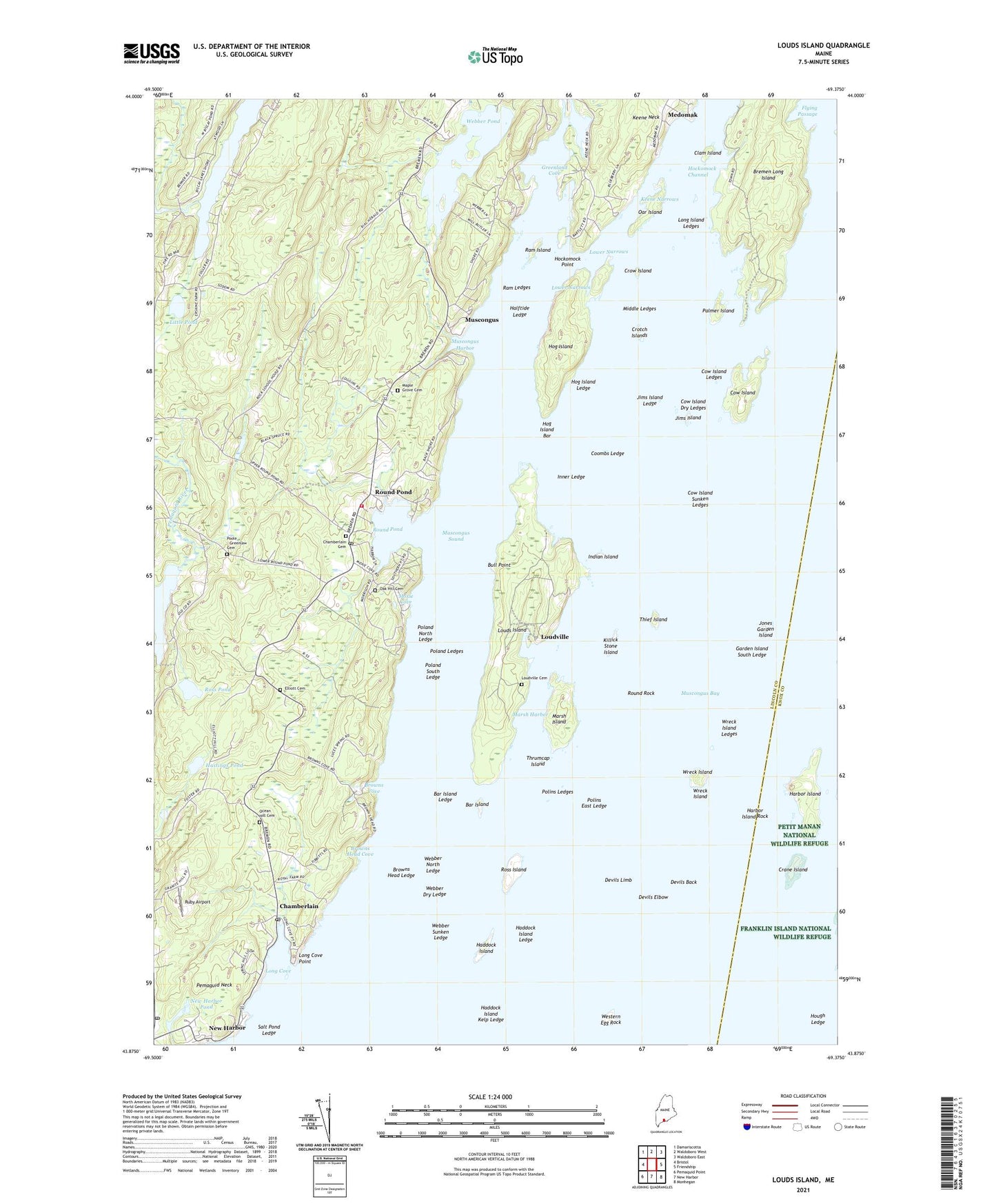
2024 topographic map quadrangle Louds Island in the state of Maine. Scale: 1:24000. Based on the newly updated USGS 7.5' US Topo map series, this map is in the following counties: Lincoln, Knox. The map contains contour data, water features, and other items you are used to seeing on USGS maps, but also has updated roads and other features. This is the next generation of topographic maps. Printed on high-quality waterproof paper with UV fade-resistant inks.
Quads adjacent to this one:
West: Bristol
Northwest: Damariscotta
North: Waldoboro West
Northeast: Waldoboro East
East: Friendship
Southeast: Monhegan
South: New Harbor
Southwest: Pemaquid Point
This map covers the same area as the classic USGS quad with code o43069h4.
Contains the following named places: Bar Island, Bar Island Ledge, Boyd Pond, Bremen Long Island, Bristol Fire Station Round Pond, Browns Cove, Browns Head Cove, Browns Head Ledge, Bull Point, Chamberlain, Chamberlain Post Office, Clam Island, Coombs Ledge, Cow Island, Cow Island Dry Ledges, Cow Island Ledges, Cow Island Sunken Ledges, Crane Island, Crotch Islands, Crow Island, Devils Back, Devils Elbow, Devils Limb, Duryea Morton Audubon Sanctuary, Flying Passage, Franklin Island Light, Garden Island South Ledge, Greenland Cove, Haddock Island, Haddock Island Kelp Ledge, Haddock Island Ledge, Halftide Ledge, Harbor Island, Harbor Island Rock, Hastings Pond, Hockomock Channel, Hockomock Nature Trail, Hockomock Point, Hog Island, Hog Island Bar, Hog Island Ledge, Hough Ledge, Indian Island, Inner Ledge, Jims Island, Jims Island Ledge, Jones Garden Island, Keene Narrows, Keene Neck, Killick Stone Island, Little Franklin Ledge, Little Pond, Long Cove, Long Cove Point, Long Island Ledges, Louds Island, Loudville, Loudville Cemetery, Lower Narrows, Maple Grove Cemetery, Marsh Harbor, Marsh Island, Middle Ledges, Moxie Cove, Muscongus, Muscongus Bay, Muscongus Harbor, Muscongus Sound, National Audubon Society Nature Camp, New Harbor, New Harbor Pond, New Harbor Pond Dam, New Harbor Post Office, Oar Island, Ocean Hill Cemetery, Palmer Island, Pemaquid Neck, Poland Ledges, Poland North Ledge, Poland South Ledge, Polins East Ledge, Polins Ledges, Rachael Carson Salt Pond Preserve, Ram Island, Ram Ledges, Ross Island, Ross Pond, Round Pond, Round Pond Post Office, Round Rock, Ruby Airport, Salt Pond Ledge, The White Church, Thief Island, Thrumcap Island, Todd Wildlife Sanctuary, Town of Bremen, Town of Bristol, Unorganized Territory of Louds Island, Webber Dry Ledge, Webber North Ledge, Webber Pond, Webber Sunken Ledge, Western Egg Rock, Wreck Island, Wreck Island Ledges, ZIP Codes: 04541, 04551, 04564