MyTopo
Turner Center Maine US Topo Map
Couldn't load pickup availability
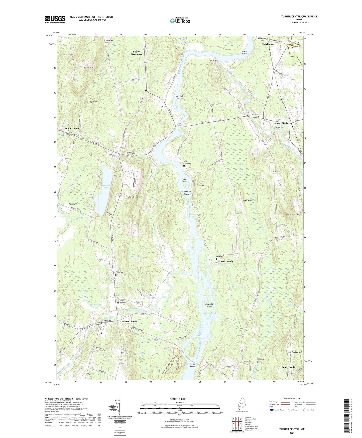
2024 topographic map quadrangle Turner Center in the state of Maine. Scale: 1:24000. Based on the newly updated USGS 7.5' US Topo map series, this map is in the following counties: Androscoggin, Kennebec. The map contains contour data, water features, and other items you are used to seeing on USGS maps, but also has updated roads and other features. This is the next generation of topographic maps. Printed on high-quality waterproof paper with UV fade-resistant inks.
Quads adjacent to this one:
West: Buckfield
Northwest: Canton
North: Livermore Falls
Northeast: Fayette
East: Wayne
Southeast: Monmouth
South: Lake Auburn East
Southwest: Lake Auburn West
This map covers the same area as the classic USGS quad with code o44070c2.
Contains the following named places: Additon Cemetery, Allen Stream, Butter Hill, Carver Cemetery, Dead River, Dead River Dam, Dead River Reservoir, Fairview Cemetery, Fairview Hill, Foss Cemetery, Francis Cemetery, Griswold Island, House Brook, Howes Corner, Howes Corner Cemetery, Island Cemetery, Keens Mills, Keens Mills Cemetery, Keith Brook, Knapp Cemetery, Leavitt Area High School, Leeds Community Church, Little Ram Island, Lovewell Island, Maple Grove Cemetery, Merrill Hill, Monument Hill, Monument Hill Trail, Morris Cemetery, Nezinscot River, North Leeds, North Turner Cemetery, Perley Cemetery, Pleasant Pond, Pleasant Pond Dam, Quaker Hill, Quaker Ridge Cemetery, Ram Island, Red Brook, River Grove Cemetery, Sand Hill, South Leeds, South Livermore, Strickland Cemetery, Stricklands, The Plains, Timberlake Cemetery, Torry Hill, Town of Leeds, Town of Turner, Tripp Middle School, True Cemetery, Turner Bridge, Turner Center, Turner Centerville Cemetery, Turner Elementary School, Turner Primary School, Turner Public Library, Turner Volunteer Fire Department North Turner Station, Turtle Island, West Leeds, West Leeds Cemetery, ZIP Codes: 04263, 04282