MyTopo
Livermore Falls Maine US Topo Map
Couldn't load pickup availability
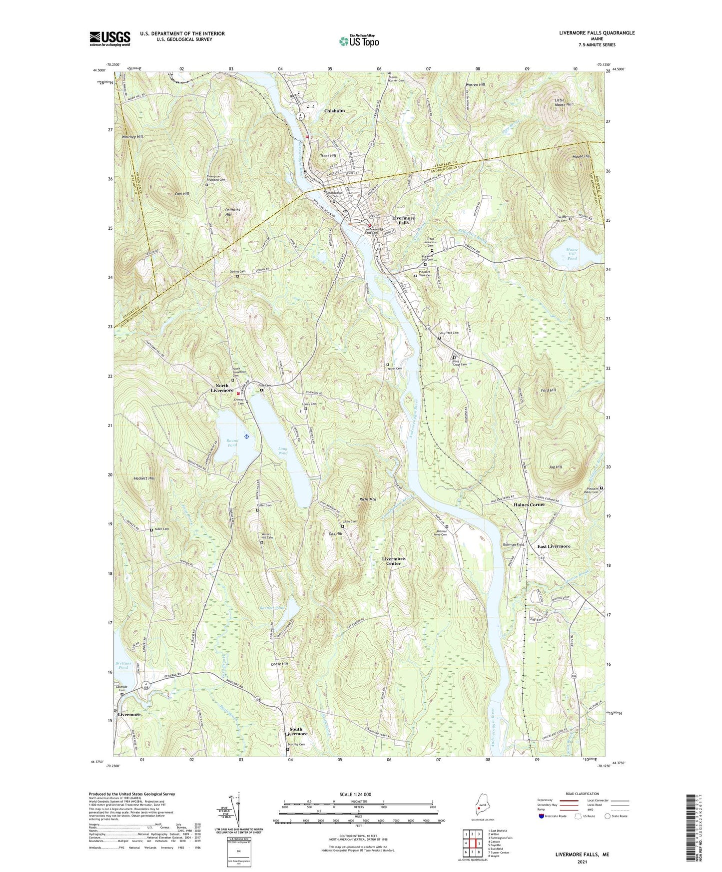
2024 topographic map quadrangle Livermore Falls in the state of Maine. Scale: 1:24000. Based on the newly updated USGS 7.5' US Topo map series, this map is in the following counties: Androscoggin, Franklin, Oxford, Kennebec. The map contains contour data, water features, and other items you are used to seeing on USGS maps, but also has updated roads and other features. This is the next generation of topographic maps. Printed on high-quality waterproof paper with UV fade-resistant inks.
Quads adjacent to this one:
West: Canton
Northwest: East Dixfield
North: Wilton
Northeast: Farmington Falls
East: Fayette
Southeast: Wayne
South: Turner Center
Southwest: Buckfield
This map covers the same area as the classic USGS quad with code o44070d2.
Contains the following named places: Alden Cemetery, Androscoggin River Reservoir, Bartlett Pond, Beals Brook, Billington Brook, Boothby Cemetery, Bowman Field, Brettuns Pond, Brettuns Pond Dam, Chase Hill, Cheney Cemetery, Chisholm, Chisholm Census Designated Place, Chisholm Square, Clay Brook, Cow Hill, East Livermore, East Livermore Church, Emmanuel Assembly of God Church, Fish Meadow Brook, Ford Brook, Ford Hill, Fuller Cemetery, Gibbs Cemetery, Goding Cemetery, Hackett Hill, Haines Corner, Hillman Ferry Cemetery, Holy Cross Cemetery, Hunton Brook, Intermediate Learning Center, Jay Fire Rescue Station 2, Jay Post Office, Jug Hill, Lakeside Cemetery, Lamb Cemetery, Little Moose Hill, Livermore, Livermore Center, Livermore Falls, Livermore Falls Cemetery, Livermore Falls Census Designated Place, Livermore Falls Dam, Livermore Falls Fire Department, Livermore Falls Middle School, Livermore Falls Police Department, Livermore Falls Post Office, Livermore Fire Department, Livermore Post Office, Long Pond, Long Pond Seaplane Base, Meadow Brook, Moose Hill, Moose Hill Cemetery, Moose Hill Pond, Mosquito Brook, Norland Church, Norlands Living History Center, North Livermore, North Livermore Cemetery, Northstar Emergency Medical Services Livermore, Noyes Cemetery, Oak Hill, Otis Dam, Philbrick Hill, Pitts Cemetery, Pleasant Hill Cemetery, Pleasant Valley Cemetery, Pleasant View Cemetery, Primary Learning Center, Redwater Brook, Richs Mountain, Round Pond, Scott Brook, Shuy Yard Cemetery, Shy Corner, Smith School, Spruce Mountain Elementary School, Spruce Mountain High School, Spruce Mountain High School - South Campus, Spruce Mountain Middle School, Spruce Mountain Primary School, Stones Corner Cemetery, Thompson Fruitland Cemetery, Town of Livermore, Town of Livermore Falls, Treat Hill, Treat Memorial Cemetery, Treat Memorial Library, Warren Hill, Waters Hill Cemetery, Western Maine Family Health Center, Whitney Hill, ZIP Codes: 04253, 04254