MyTopo
Gibson Island Maryland US Topo Map
Couldn't load pickup availability
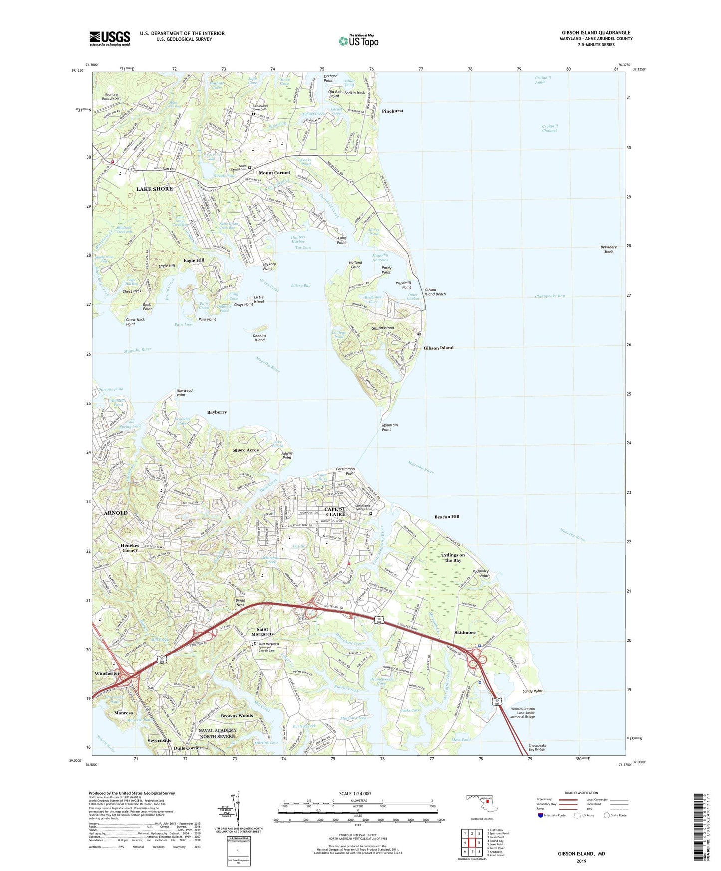
2019 topographic map quadrangle Gibson Island in the state of Maryland. Scale: 1:24000. Based on the newly updated USGS 7.5' US Topo map series, this map is in the following counties: Anne Arundel. The map contains contour data, water features, and other items you are used to seeing on USGS maps, but also has updated roads and other features. This is the next generation of topographic maps. Printed on high-quality waterproof paper with UV fade-resistant inks.
Quads adjacent to this one:
West: Round Bay
Northwest: Curtis Bay
North: Sparrows Point
Northeast: Swan Point
East: Love Point
Southeast: Kent Island
South: Annapolis
Southwest: South River
Contains the following named places: Adams Point, Admirals Walk, Amberly, Arcadia, Arnold Census Designated Place, Arnold Park, Ashlar Pond, Atlantis, Baltimore Lighthouse, Bay Hills, Bay Hills Country Club, Bay Hills Shopping Center, Bay Manor Nursing Home, Bayberry, Bayhead, Beacon Hill, Beacon View, Bell Forest, Bellerive Village, Belvedere Yacht Club, Belvidere Shoal, Blackhole Creek, Blackhole Creek Bog, Bodkin Elementary School, Bodkin Plains, Bohdal Pond, Boulevard Park, Briar Lea, Briarwood, Brice Manor, Broad Creek, Broad Neck, Broad Neck Medical Center, Broadneck Elementary School, Broadneck High School, Broadneck Park, Broadwater Beach, Browns Woods, Browns Woods Villa, C W Martin Heliport, Cape Saint Claire, Cape Saint Claire Census Designated Place, Cape Saint Claire Elementary School, Cape Saint Claire Recreation Area, Cape Saint Claire Shopping Center, Capetowne, Captains Choice, Cat Branch, Cedarwood Cove, Cedarwood Cove Cemetery, Central Sodding Farms, Cherrywood, Chesapeake Bay Institute Field Laboratory Jo, Chesapeake Bay Middle School, Chesapeake High School, Chesapeake Montessori School, Chesapeake Oaks, Chest Neck, Chest Neck Point, College Parkway Shopping Center, Colonial Manor Trailer Park, Cooks Pond, Cool Spring Cove, Cooleys Pond, Cornfield Creek, Craighill Channel, Deep Creek, Deer Creek, District 5, Dobbins Island, Dobbins Pond, Dorado Hills, Dorado Village, Downs Memorial Park, Dulls Corner, Eagle Hill, Eagle Hill Bog, Factory Stores - Bay Bridge Market Place Shopping Center, Fairwinds Marina, Fairwood, Forest Meadows, Forked Creek, Foxmoor, Fresh Pond, Fresh Pond Bog, Gayfields Farm, Gibson Island, Gibson Island Beach, Gibson Island Golf Course, Gibson Island Marina, Gibson Island Yacht Club, Goose Cove, Governor Sharpes Millpond, Grays Creek, Grays Point, Great Meadows, Green Gables, Greenholly, Henekes Corner, Herons Watch, Hickory Point, Hidden Ridge, Holland Point, Holly Anna Acres, Hollyberry Woods, Homewood Cove, Hunters Harbor, Indian Hills, Inner Harbor, Jacks Cove, James Pond, Jubb Cove, Kimberly Woods Village, Kingston Estates, Lake Claire, Lake Placid, Lake Shore, Lake Shore Census Designated Place, Lake Shore Recreation Area, Landhaven, Little Island, Little Magothy River, Locust Cove, Long Cove, Long Point, Long Point on the Magothy, Longview, Lyndale, Lynwood Village, Magothy Narrows, Magothy River, Magothy River Light, Main Creek Bog, Manresa, Manresa Pond, Martins Cove, Martins Cove Farm, Mathias Cove, Meredith Creek, Meredith Homes, Mezick Ponds, Milburn on the Magothy, Minnow Creek, Moss Pond, Mount Carmel, Mount Carmel Cemetery, Mountain Point, Mountain Road Airport, Mountain Wood, North Grays Creek Bog, North Shore, Northport, Oakland Hill, Oakmont, Old Bee Point, Old Mill Bottom Estates, Orchard Point, Otter Pond, Park Creek, Park Lake, Park Point, Persimmon Point, Pettebone Farms, Pinehurst, Pinehurst Landing Marina, Pinehurst on the Bodkin, Pleasant Plains, Podickory Creek, Podickory Point, Point-O-Woods, Purdy Point, Redhouse Cove, Revell Downs, Riding Woods, Ridout Creek, Rock Point, Saint Johns Woods, Saint Margaret Medical Center, Saint Margarets, Saint Margarets Episcopal Church Cemetery, Saint Margarets Farm, Sandy Point, Sandy Point Ferry Terminal, Sandy Point Lighthouse, Sandy Point State Park, Saybrooke, Scheides Cove, Severnside, Shady Pond Bog, Shirleyville, Shore Acres, Shorts Creek, Sillery Bay, Sillery Bay Forest, Sillman Estates, Skidmore, South Grays Creek Bog, Spriggs Pond, Stinchcomb-Tydings Cemetery, Stonington, Sturbridge, Sylvan View, Tanglewood, Tar Cove, Tate Landing, The Meadows, Tree Tops, Tydings on the Bay, Ulmstead Acres, Ulmstead Cove, Ulmstead Estates, Ulmstead Gardens, Ulmstead Point, Ventnor, Ventnor Forest, Walnut Ridge, Weatherly, Westinghouse Bay, Wharf Creek, Whispering Woods, Whitehall Beach, Whitehall Estates, Whitehall Manor, Whitehall Shopping Center, Wilsons Wharf, Winchester, Winchester Pond, Windermere Estates, Windmill Point, Woods Landing, Yorktown, ZIP Codes: 21012, 21056, 21122, 21409