MyTopo
Sparrows Point Maryland US Topo Map
Couldn't load pickup availability
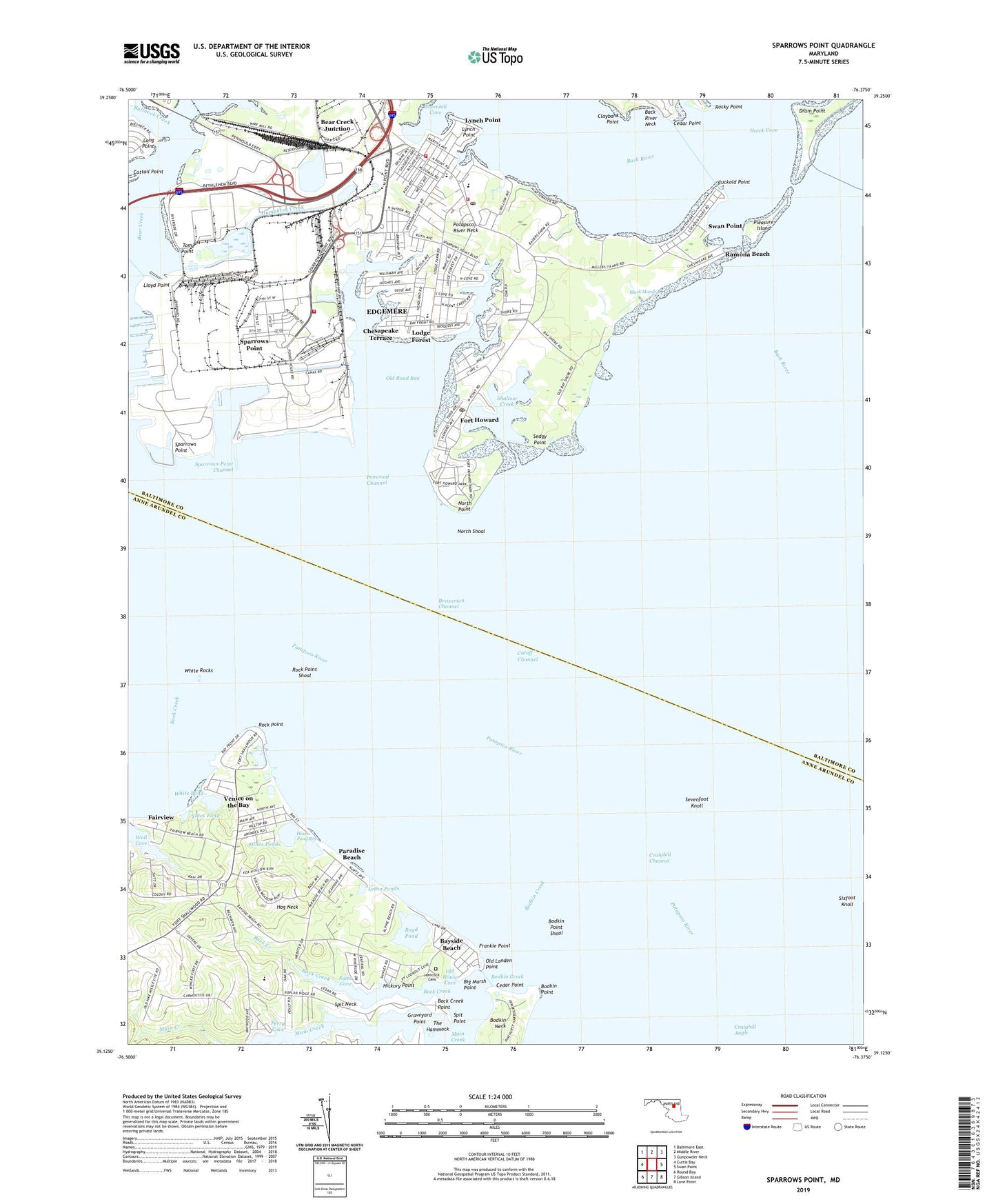
2023 topographic map quadrangle Sparrows Point in the state of Maryland. Scale: 1:24000. Based on the newly updated USGS 7.5' US Topo map series, this map is in the following counties: Baltimore, Anne Arundel. The map contains contour data, water features, and other items you are used to seeing on USGS maps, but also has updated roads and other features. This is the next generation of topographic maps. Printed on high-quality waterproof paper with UV fade-resistant inks.
Quads adjacent to this one:
West: Curtis Bay
Northwest: Baltimore East
North: Middle River
Northeast: Gunpowder Neck
East: Swan Point
Southeast: Love Point
South: Gibson Island
Southwest: Round Bay
This map covers the same area as the classic USGS quad with code o39076b4.
Contains the following named places: Alloway, Alpine Beach, Amigonian School, Back Creek, Back Creek Point, Back River, Baltimore County Fire Department Edgemere - Station 9, Baltimore County Fire Department Sparrows Point - Station 57, Baptist Christian School, Battery Clagett, Battery George Sykes, Battery Harris, Battery Hartshorne, Battery Lazear, Battery Nicholson, Battery Stricker, Bay Shore Park, Bayshore, Bayside Beach, Baywood Mobile Home Park, Bear Creek Junction, Belhaven Beach, Belhaven Woods, Bethel Assembly of God Church, Big Marsh Point, Black Marsh, Bodkin Boat Club, Bodkin Creek, Bodkin Manor, Bodkin Neck, Bodkin Point, Bodkin Point Shoal, Boyd Pond, Brewerton Channel, Bullneck Creek, Camp Kaufman, Cattail Point, Cedar Point, Chase Wood Run, Chesapeake Terrace, Chesapeake Terrace Elementary School, Claphams Point, Claybank Point, Craighill Angle, Craighill Channel Front Upper Range Light, Cross Roads Community Church, Cuckold Point, Cutoff Channel, Darinton, Delmar Baptist Church, District 3, Drum Point, Edgemere, Edgemere Bible Church, Edgemere Census Designated Place, Edgemere Community Chapel, Edgemere Elementary School, Edgemere Minilibrary Baltimore County Public Library, Fairhaven Beach, Fairview, Fairview Marina, First Christian Church, First Cove, Fitzell, Fort Howard, Fort Howard Community Church, Fort Howard Park, Fort Howard Post Office, Fort Howard School, Fort Howard Veterans Affairs Outpatient Clinic, Fort Smallwood, Fort Smallwood Elementary School, Fort Smallwood Park, Fort Smallwood School, Frankie Point, Geisler Point Marina, Graveyard Point, Greenhill Cove, Hammock Island Marina, Hampton Chase, Hancock Cemetery, Hancocks Resolution Park, Hathaway Island, Hickory Point, Hines Pond Bog, Hines Ponds, Hog Neck, Hopkins Elder Plus Assisted Living Center, Hughes Memorial Presbyterian Church, Humphrey Creek, Jones Creek, Kurtz Beach, Letha Ponds, Lincoln Mobile Home Park, Little Marsh Point, Lloyd Point, Lodge Forest, Lodge Forest United Methodist Church, Long Point, Lynch Point, Main Creek, Maryland Beach, New Hope Church, Nike Site BA-43C, Nike Site BA-43L, North Point, North Point Creek, North Point Edgemere Volunteer Fire Department Station 26, North Shoal, Old House Cove, Old Landen Point, Old Road Bay, Paradise Beach, Pasadena Beach, Patapsco River, Patapsco River Neck, Penwood Channel, Penwood Christian Church, Penwood Mobile Home Park, Penwood Park, Perry Cove, Pine Crest North, Pine Crest West, Pinehurst Harbour, Pleasure Cove Marina, Pleasure Island, Poplar Ridge, Ramona Beach, Rock Creek Park, Rock Point, Rock Point Shoal, Rockwood Beach, Rocky Point, Saint Lukes Church, Saint Lukes School, Sams Cove, Second Cove, Sedgy Point, Sevenfoot Knoll, Shallow Creek, Shallow Creek Park, Shiloh Baptist Church, Sixfoot Knoll, Sparrows Point, Sparrows Point Channel, Sparrows Point High School, Sparrows Point Industrial Complex, Sparrows Point Middle School, Sparrows Point Post Office, Spit Neck, Spit Point, Springdale, Swan Point, The Hammock, Tom Point, Venice on the Bay, Wall Cove, Water View, White Pond, White Rocks, Yates Pond, ZIP Codes: 21052, 21219