MyTopo
Lonaconing Maryland US Topo Map
Couldn't load pickup availability
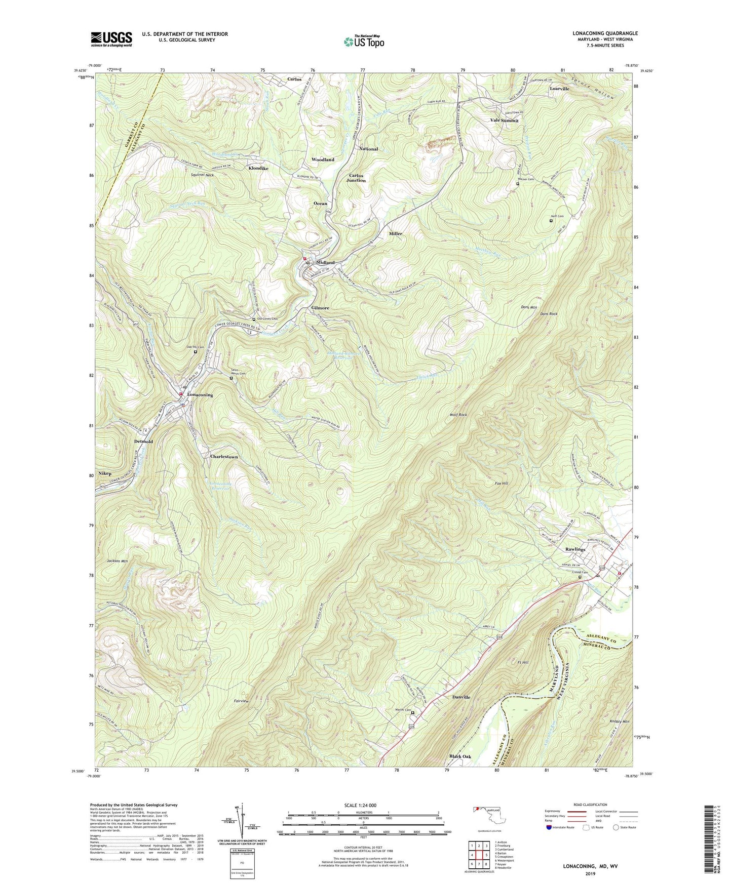
2023 topographic map quadrangle Lonaconing in the states of Maryland, West Virginia. Scale: 1:24000. Based on the newly updated USGS 7.5' US Topo map series, this map is in the following counties: Allegany, Mineral, Garrett. The map contains contour data, water features, and other items you are used to seeing on USGS maps, but also has updated roads and other features. This is the next generation of topographic maps. Printed on high-quality waterproof paper with UV fade-resistant inks.
Quads adjacent to this one:
West: Barton
Northwest: Avilton
North: Frostburg
Northeast: Cumberland
Southeast: Headsville
South: Keyser
Contains the following named places: Ashcabin Run, Bier, Carlos, Carlos Census Designated Place, Carlos Junction, Carlos United Methodist Church, Charlestown, Cresap Cemetery, Dans Mountain, Dans Mountain State Park, Dans Mountain Wildlife Management Area, Dans Rock, Danville, Danville Census Designated Place, Detmold, Detmold Census Designated Place, District 10 Lonaconing, District 17 Vale Summit, District 18 Midland/Shaft, District 18 Ocean, District 31 McCoole, District 7 Rawlings, Elklick Run, Fairview, Fort Hill, Fox Hill, Georges Creek Ambulance Service, George's Creek Elementary School, Gilmore, Gilmore Census Designated Place, Good Will Volunteer Fire Company 1, Grace United Methodist Church, Hill Run, Jackson Mountain, Jackson Run, Klondike, Klondike Census Designated Place, Koontz, Koontz Run, Loarville, Lonaconing, Lonaconing Historic District, Lonaconing Police Department, Lonaconing Post Office, Lonaconing Reservoir, Marsh Field Airport, Matthew Run, Midland, Midland Fire Company 1, Midland Post Office, Midland School, Midland-Gilmore Reservoir, Miller, Mountainview Landfill, National, National Census Designated Place, Neff Cemetery, Neff Run, Nikep, Nikep Census Designated Place, Oak Hill Cemetery, Ocean, Ocean Census Designated Place, Old Coney Cemetery, Porters, Rawlings, Rawlings Census Designated Place, Rawlings Heights, Rawlings Post Office, Rawlings United Methodist Church, Rawlings Volunteer Fire Department, Saint Josephs Roman Catholic Church, Saint Josephs School, Saint Marys Cemetery, Squirrel Neck, Squirrel Neck Run, Staub Run, Town of Lonaconing, Town of Midland, Vale Run, Vale Summit, Vale Summit Census Designated Place, Vale Summit United Methodist Church, Warner Cemetery, Waxler Cemetery, Westmar Middle School, WFWM-FM (Frostburg), Winebrenner Run, WKGO-FM (Cumberland), WLIC-FM (Frostburg), Wolf Rock, Woodland, Woodland Census Designated Place, Woodland Creek, Woodland United Methodist Church, WROG-FM (Cumberland), ZIP Codes: 21539, 21542, 21557