MyTopo
Colonial Beach North Virginia US Topo Map
Couldn't load pickup availability
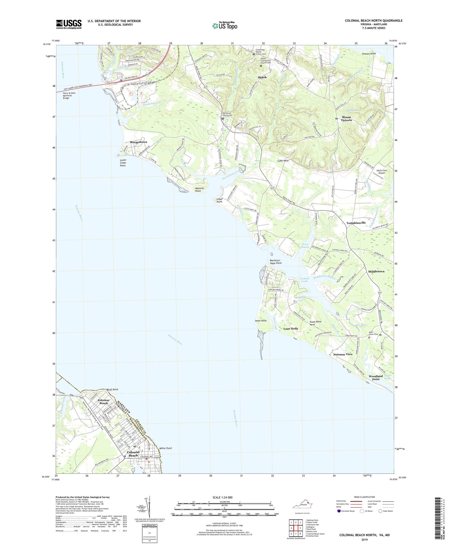
2022 topographic map quadrangle Colonial Beach North in the states of Maryland, Virginia. Scale: 1:24000. Based on the newly updated USGS 7.5' US Topo map series, this map is in the following counties: Westmoreland, Charles, King George. The map contains contour data, water features, and other items you are used to seeing on USGS maps, but also has updated roads and other features. This is the next generation of topographic maps. Printed on high-quality waterproof paper with UV fade-resistant inks.
Quads adjacent to this one:
West: Dahlgren
Northwest: Mathias Point
North: Popes Creek
Northeast: Charlotte Hall
East: Rock Point
Southeast: Stratford Hall
South: Colonial Beach South
Southwest: Rollins Fork
This map covers the same area as the classic USGS quad with code o38076c8.
Contains the following named places: Anchorage Anchors, Aqua-Land Airport, Aqua-Land Marina, Bachelors Hope Point, Banks O'Dee, Bluff Point, Central Rappahannock Regional Library Abraham and William Cooper Memorial Branch, Classic Shore, Clifton Creek, Clifton on the Potomac, Cobb Neck, Colonial Beach, Colonial Beach Elementary School, Colonial Beach Fire Meeting House, Colonial Beach High School, Colonial Beach Historical Society's Museum at Colonial Beach, Colonial Beach Police Department, Colonial Beach Post Office, Colonial Beach Rescue Squad Station 1, Colonial Beach Shopping Center, Colonial Beach Volunteer Fire Department Engine Company 1, Crain Memorial Park, Cuckold Creek, District 5 Thompkinsville, Ditchley Prong, Doctor Thomas L Higdon Elementary School, First Baptist Church of Colonial Beach, Goldman Creek, Good Hope Baptist Church Cemetery, Harris Lot, Harry W Nice Memorial Bridge, Holy Ghost Cemetery, Holy Ghost Church, Idlewood Acres, Issue, Laidlow Ferry, Lloyd Creek, Lloyd Point, Lone Holly, Lower Cedar Point, Ludlow Ferry, Mary Washington Health Center, Maryland Transportation Authority Police Station Governor Harry Nice Memorial Bridge, Matthews Cove, Middletown, Middletown Branch, Mill Run, Morgantown, Morgantown Generating Plant, Mount Victoria, Mount Victoria Post Office, Mount Victoria School, Old Christ Church, Old Christ Church Cemetery, Pasquahanza Creek, Perry Branch, Persimmon Point Creek, Piccowaxen Creek, Piccowaxen Middle School, Pilots Cove Airport, Potomac Beach, Potomac View, Ravens Crest Creek, Rosier Creek, Saint Marys Episcopal Church, Shaws Branch, Shiloh, Shiloh Church, Shiloh Community Church Cemetery, Smoots Point, Southern Park, Swan Point, Swan Point Golf Course, Swan Point Neck, Swindler Creek, Tompkinsville, Tompkinsville School, Town of Colonial Beach, Town of Colonial Beach Sewage Treatment Plant, Trunk Gut, Waverly Creek, Waverly Point, Wayside, Weir Creek, White Point, Wilkerson Creek, Wise Marsh, Woodland Point, ZIP Codes: 20645, 20664