MyTopo
Ashby Massachusetts US Topo Map
Couldn't load pickup availability
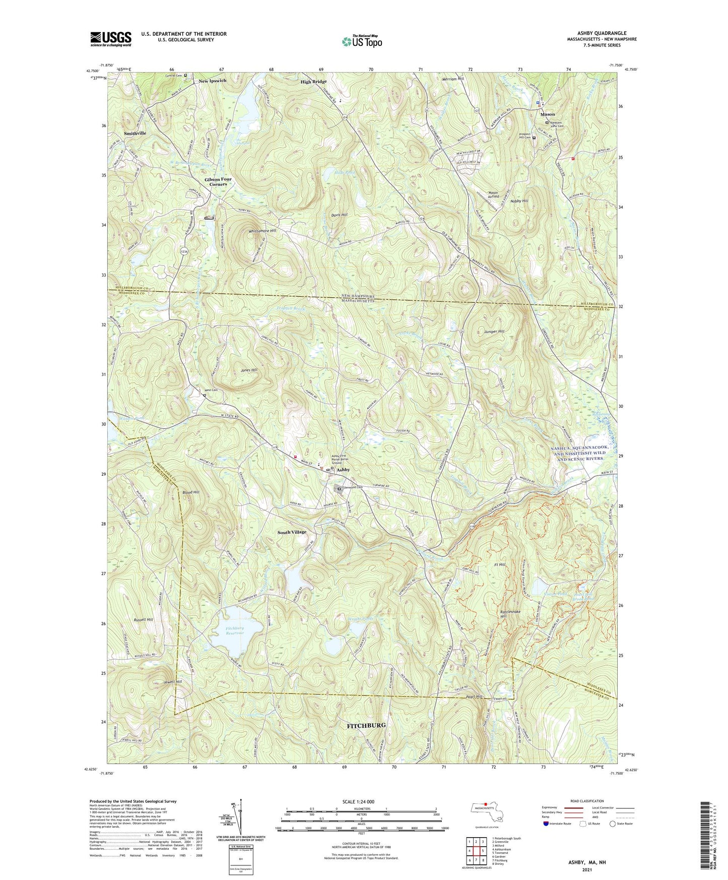
2024 topographic map quadrangle Ashby in the states of Massachusetts, New Hampshire. Scale: 1:24000. Based on the newly updated USGS 7.5' US Topo map series, this map is in the following counties: Middlesex, Hillsborough, Worcester. The map contains contour data, water features, and other items you are used to seeing on USGS maps, but also has updated roads and other features. This is the next generation of topographic maps. Printed on high-quality waterproof paper with UV fade-resistant inks.
Quads adjacent to this one:
West: Ashburnham
Northwest: Peterborough South
North: Greenville
Northeast: Milford
East: Townsend
Southeast: Shirley
South: Fitchburg
Southwest: Gardner
Contains the following named places: Apostolic Church, Ash Swamp, Ashby, Ashby Common, Ashby Congregational Church, Ashby Elementary School, Ashby Emergency Medical Services, Ashby Fire Department, Ashby First Parish Burial Ground, Ashby Free Public Library, Ashby Police Department, Ashby Post Office, Ashby Reservoir, Ashby Reservoir Dam, Ashby Town Hall, Barrett Hill Farm, Black Fly Brook, Blood Hill, Camp Kirby, Camp Middlesex, Central Cemetery, Damon Pond, Davis Hill, Fitchburg Reservoir, Fitchburg Reservoir North Dam, Fitchburg Reservoir South Dam, Fitchburg Reservoir South Dike, Fitchburg State Forest, Fort Hill, Gibson Four Corners, Gibson Pond, Glenwood Cemetery, Hoar Pond, Jewell Hill, Jones Hill, Juniper Hill, Lakeview School, Locke Brook, Lower Wrights Pond, Marshall State Forest, Mascenic Regional High School, Mason, Mason Airfield, Mason Brook, Mason Congregational Church, Mason Elementary School, Mason Fire and Rescue, Mason Police Department, Merriam Hill, New Ipswich, New Ipswich Congregational Church, Nobby Hill, Our Redeemer Chapel, Pearl Hill, Pearl Hill Brook, Pearl Hill Brook Pond, Pearl Hill State Park, Pleasant View Cemetery, Prospect Hill Cemetery, Rattlesnake Hill, Rocky Brook, Rogersville, Russell Hill, Sleeping Monk Farm, Smithville, Souhegan River Watershed Dam Number 19, South Branch Souhegan River, South Village, The Whirlpool, Town of Ashby, Town of New Ipswich, Trapfall Brook, Upper Wrights Pond, Vinton Pond, Walker Brook, Watatic Pond, Water Loom Pond, West Branch Souhegan River, West Cemetery, West Souhegan River, Whittemore Hill, Willard Brook State Forest, Wright Ponds, ZIP Codes: 01431, 01474, 03048, 03071