MyTopo
Greenville New Hampshire US Topo Map
Couldn't load pickup availability
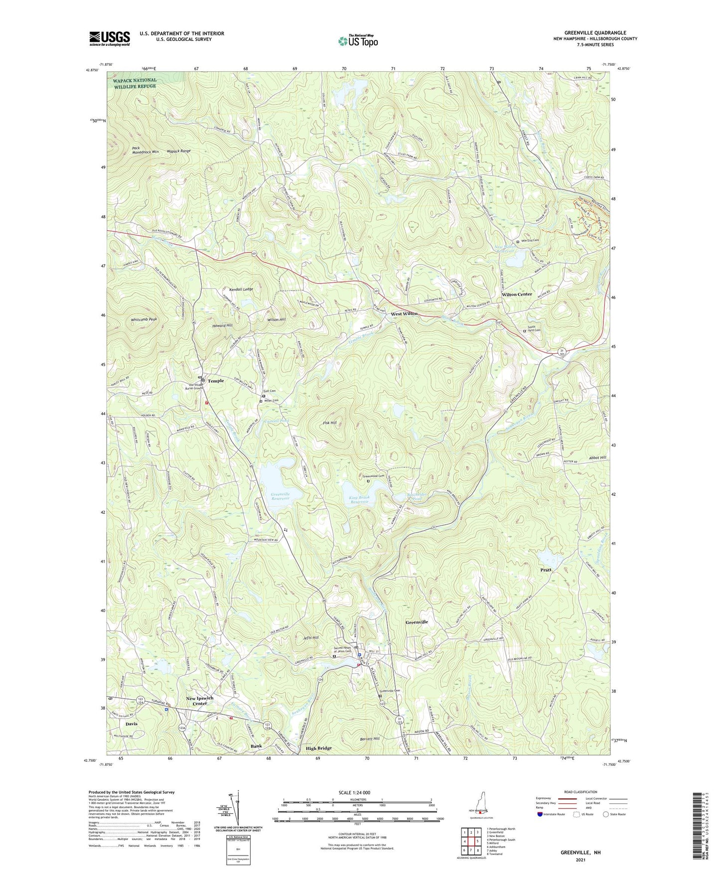
2024 topographic map quadrangle Greenville in the state of New Hampshire. Scale: 1:24000. Based on the newly updated USGS 7.5' US Topo map series, this map is in the following counties: Hillsborough. The map contains contour data, water features, and other items you are used to seeing on USGS maps, but also has updated roads and other features. This is the next generation of topographic maps. Printed on high-quality waterproof paper with UV fade-resistant inks.
Quads adjacent to this one:
West: Peterborough South
Northwest: Peterborough North
North: Greenfield
Northeast: New Boston
East: Milford
Southeast: Townsend
South: Ashby
Southwest: Ashburnham
This map covers the same area as the classic USGS quad with code o42071g7.
Contains the following named places: Appleton Elementary School, Bank, Barrett Hill, Batchelder Pond, Blood Brook, Blood Brook Reservoir, Boynton Middle School, Burton Pond, Burton Pond Dam, Caswell Pond, Central Elementary School, Davis, Davisville, East Cemetery, Federated Church, First Unitarian Congregational Society, Fisk Hill, Furnace Brook, Good News Bible Church, Greenville, Greenville Cemetery, Greenville Census Designated Place, Greenville Elementary School, Greenville Fire Department, Greenville Post Office, Greenville Reservoir, Greenwood Cemetery, High Bridge, Howard Hill, Ipswich Post Office, Jefts Hill, Kendall Ledge, King Brook, King Brook Reservoir, Lyndeborough Post Office, Mill Brook Reservoir, Miller Cemetery, Miller Grange, New Ipswich Center, New Ipswich Police Department, New Ipswich Post Office, New Ipswich Volunteer Fire Department, New Wilton Reservoir, Old Village Burial Ground, Old Wilton Reservoir, Otis Company Dam Number 1, Pratt, Pratt Pond, Pratt Pond Dam, Pratt Pond Dike and Spillway, Russell-Abbott State Forest, Sacred Heart Catholic Church, Sacred Heart of Jesus Cemetery, Solon Mansfield Memorial Library, Souhegan River Reservoir Number Thirteen, Souhegan River Watershed Dam Number 10A, Souhegan River Watershed Dam Number 12A, Souhegan River Watershed Dam Number 13, Souhegan River Watershed Dam Number 14, Souhegan River Watershed Dam Number 15, Souhegan River Watershed Dam Number 25B, Souhegan River Watershed Dam Number 26, Souhegan River Watershed Dike Number 12A, Souhegan River Watershed Dike Number 13, Souhegan Valley Ambulance, South Yard Cemetery, Stockwell Brook Dam, Temple, Temple - Greenville Police Department, Temple Brook, Temple Congregational Church, Temple Elementary School, Temple Heliport, Temple Post Office, Temple Town Hall, Temple Volunteer Fire Department, Town of Greenville, Town of Temple, Town of Wilton, Town of Wilton Ambulance Services / Wilton - Lyndeborough - Temple Ambulance Service, Universalist Church, Vale End Cemetery, Ward Dam, Water Loom Pond Dam, West Wilton, Whitcomb Peak, Wilson Hill, Wilton Center, Wilton Center Town House, ZIP Code: 03086