MyTopo
Colrain Massachusetts US Topo Map
Couldn't load pickup availability
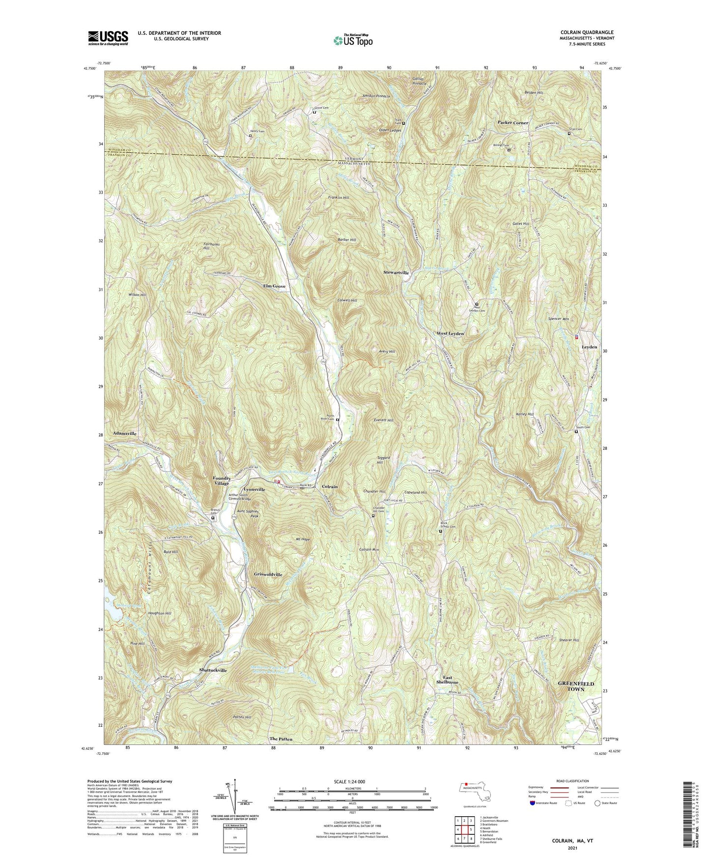
2021 topographic map quadrangle Colrain in the states of Massachusetts, Vermont. Scale: 1:24000. Based on the newly updated USGS 7.5' US Topo map series, this map is in the following counties: Franklin, Windham. The map contains contour data, water features, and other items you are used to seeing on USGS maps, but also has updated roads and other features. This is the next generation of topographic maps. Printed on high-quality waterproof paper with UV fade-resistant inks.
Quads adjacent to this one:
West: Heath
Northwest: Jacksonville
North: Governors Mountain
Northeast: Brattleboro
East: Bernardston
Southeast: Greenfield
South: Shelburne Falls
Southwest: Ashfield
Contains the following named places: Adamsville, Amidon Pinnacle, Arthur Smith Covered Bridge, Aunt Sophies Peak, Avery Hill, Bald Hill, Barber Hill, Belden Hill, Billings Cemetery, Borden Brook, Branch Cemetery, Brandy Brook, Brick School Cemetery, Browning Brook, Cary Brook, Catamount Hills, Chandler Hill, Chandler Hill Cemetery, Colrain, Colrain Central School, Colrain Fire Department, Colrain Mountain, Colrain Police Department, Colrain Post Office, Colwell Hill, Copeland Hill, East Branch North River, East Colrain Church, East Shelburne, Elm Grove, Everett Hill, Fairbanks Hill, Fort Lucas, Fort Morris, Fort Morrison, Foundry Brook, Foundry Village, Fox Brook, Franklin Hill, Gallup Pinnacle, Gates Hill, Griswoldville, Groll Cemetery, Grove Cemetery, Harris Brook, Henry Cemetery, Hibbard Brook, Holden Brook, Houghton Brook, Houghton Hill, Johnson Brook, Katley Brook, Katley Hill, Kendall Company Number 1 Dam, Leyden, Leyden Fire Department, Leyden Police Department, Leyden School, Leyden State Forest, Leyden United Methodist Church, Lyonsville, McClellan Brook, McLeod Pond, McLeod Pond Dam, Meadow Brook, Miller Brook, Mount Hope, North River, North River Cemetery, North River Reservoir, Olden Ledges, Packer Corner, Patten Hill, Pine Hill, Pine Hill Orchards, Roaring Brook, Shattuckville, Shearer Hill, Shelburne Falls Fire District Dam, Shelburne Falls Fire District Reservoir, South Cemetery, Spencer Mountain, Spur Brook, Stafford Brook, Stark Cemetery, Stewart Brook, Stewartville, Stowe Brook, Taggard Hill, Taylor Brook, Thorne Brook, Town of Colrain, Town of Leyden, Vaughn Brook, West Branch North River, West Leyden, West Leyden Cemetery, Wilson Hill, Workman Brook, ZIP Code: 01340