MyTopo
Brattleboro Vermont US Topo Map
Couldn't load pickup availability
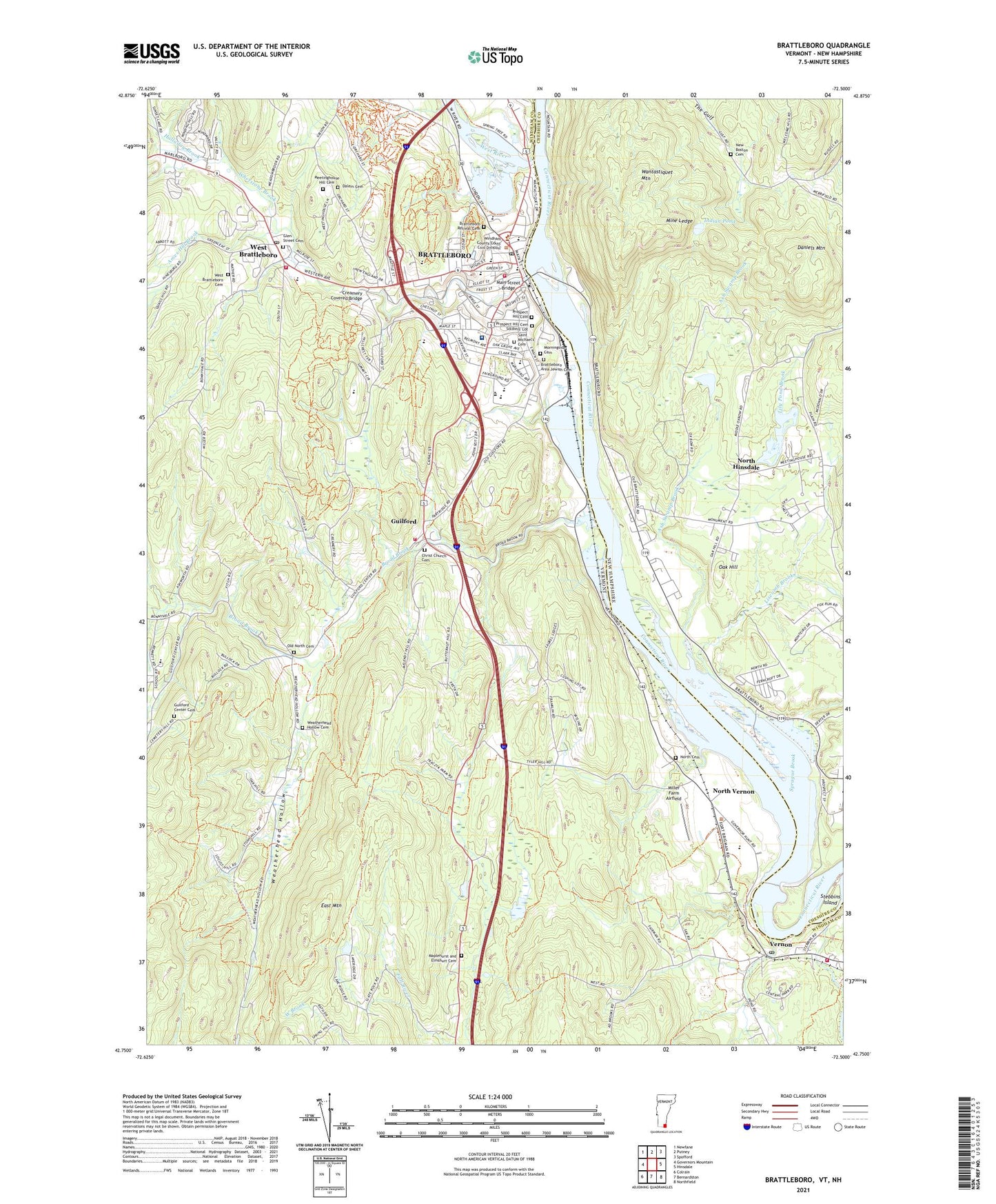
2024 topographic map quadrangle Brattleboro in the states of Vermont, New Hampshire. Scale: 1:24000. Based on the newly updated USGS 7.5' US Topo map series, this map is in the following counties: Windham, Cheshire. The map contains contour data, water features, and other items you are used to seeing on USGS maps, but also has updated roads and other features. This is the next generation of topographic maps. Printed on high-quality waterproof paper with UV fade-resistant inks.
Quads adjacent to this one:
West: Governors Mountain
Northwest: Newfane
North: Putney
Northeast: Spofford
East: Hinsdale
Southeast: Northfield
South: Bernardston
Southwest: Colrain
This map covers the same area as the classic USGS quad with code k42072g5.
Contains the following named places: Academy School, Academy School Library, Agape Christian Fellowship, Algiers, Algiers Census Designated Place, Alls Souls Church, Ames Hill Brook, Asa Keys Medical Library, Ash Swamp Brook, Austine School for the Deaf and Hard of Hearing, Austine School Library, Baha'i Community Church, Bell Brook, Bethel Chapel Assembly of God Church, Brattleboro, Brattleboro Area Jewish Cemetery, Brattleboro Area Middle School, Brattleboro Census Designated Place, Brattleboro Chamber of Commerce, Brattleboro Community School, Brattleboro Country Club, Brattleboro Courthouse Building, Brattleboro Downtown Historic District, Brattleboro Fire Department Central Station, Brattleboro Fire Department Station 2, Brattleboro Memorial Hospital, Brattleboro Memorial Hospital Helipad, Brattleboro Memorial Hospital Library, Brattleboro Municipal Center, Brattleboro Museum and Art Center, Brattleboro Music Center Office, Brattleboro Music Center School, Brattleboro Post Office, Brattleboro Retreat Cemetery, Brattleboro Retreat Healthcare, Brattleboro Retreat Tower, Brattleboro Senior Center, Brattleboro State Office Building, Brattleboro Town Manager's Office, Brattleboro Transportation Center, Brattleboro Union High School, Broad Brook, Brooks House, Brooks House Mall Shopping Center, Brooks Memorial Library, Canal Street School, Central Park Station, Centre Church, Christ Church, Christ Church Cemetery, Christian Heritage School, Church of Christ, Community Bible Chapel, Community Schoolhouse, Connecticut River Reservoir, Cotton Mill Hill Cemetery, Creamery Covered Bridge, Crowell Park, Dalem Cemetery, Daniels Mountain, East Mountain, Esteyville School, Fairfield Plaza Shopping Center, Fairview Village, First Baptist Church, First Church of Christ Scientist, First Congregational Church, First United Methodist Church, Fort Dummer Cemetery, Fort Dummer Monument, Fort Dummer State Park, Francis Hicks Memorial School, Glen Street Cemetery, Green Mountain Chapel, Green Street School, Guilford, Guilford Center, Guilford Center Cemetery, Guilford Central School, Guilford Community Church, Guilford Volunteer Fire Department, Halladay Brook, Harris Hill Ski Jump, Higley School, Hilltop Montessori School, Hinsdale Junior High School, Hinsdale Raceway, Indian Pond, Ker - Westerlund Ambulance Service, Kingdom Hall of Jehovahs Witnesses, Lily Pond Brook, Linden Lodge, Liscomb Brook, Living Memorial Park, Living Memorial Park Ski Area, Main Street Bridge, Maplehurst and Elmshurt Cemetery, Masonic Temple, Meadows School, Meetinghouse Hill Cemetery, Miller Farm Airfield, Mine Ledge, Morningside Cemetery, Mountain Home Trailer Park, Neighborhood Schoolhouse, New Boston Cemetery, North Cemetery, North Hinsdale, North Hinsdale Community Church, North Vernon, Oak Grove School, Oak Hill, Old North Cemetery, Outing Club, Pine Heights at Brattleboro Center for Nursing and Rehabilitation, Pliny Park, Prospect Hill Cemetery, Prospect Hill Cemetery Soldiers' Lot, Prouty Center for Child Development, Rescue Incorporated Division 1, Saint Michael's Cemetery, Saint Michaels Church, Saint Michaels Episcopal Church, Saint Michaels Roman Catholic School, Seventh Day Adventist Church, Sprague Brook, Stebbins Island, Sunrise Trail, Sunset Trail, The Common, The Oxbow, The Retreat Trails, Thompson House, Town of Brattleboro, Town of Guilford, Town of Hinsdale, Town of Vernon, Trinity Church, United Pentecostal Church, Vermont State Patrol Troop D, Vermont Yankee Nuclear Power Corporation Energy Information Center, Vermont Yankee Nuclear Power Station, Vernon, Vernon Dam, Vernon Elementary School, Vernon Post Office, Vernon Volunteer Fire Department, Wantastiquet Mountain, Weatherhead Hollow, Weatherhead Hollow Cemetery, Weatherhead Hollow School, Wells Fountain, West Brattleboro, West Brattleboro Baptist Church, West Brattleboro Cemetery, West Brattleboro Census Designated Place, West Brattleboro Post Office, West River, Whetsone Park, Whetstone Brook, Windham Regional Career Center, Windham Southeast Supervisory Union, WKVT-AM (Brattleboro), WTSA-AM (Brattleboro), ZIP Codes: 03451, 05354