MyTopo
Edgartown Massachusetts US Topo Map
Couldn't load pickup availability
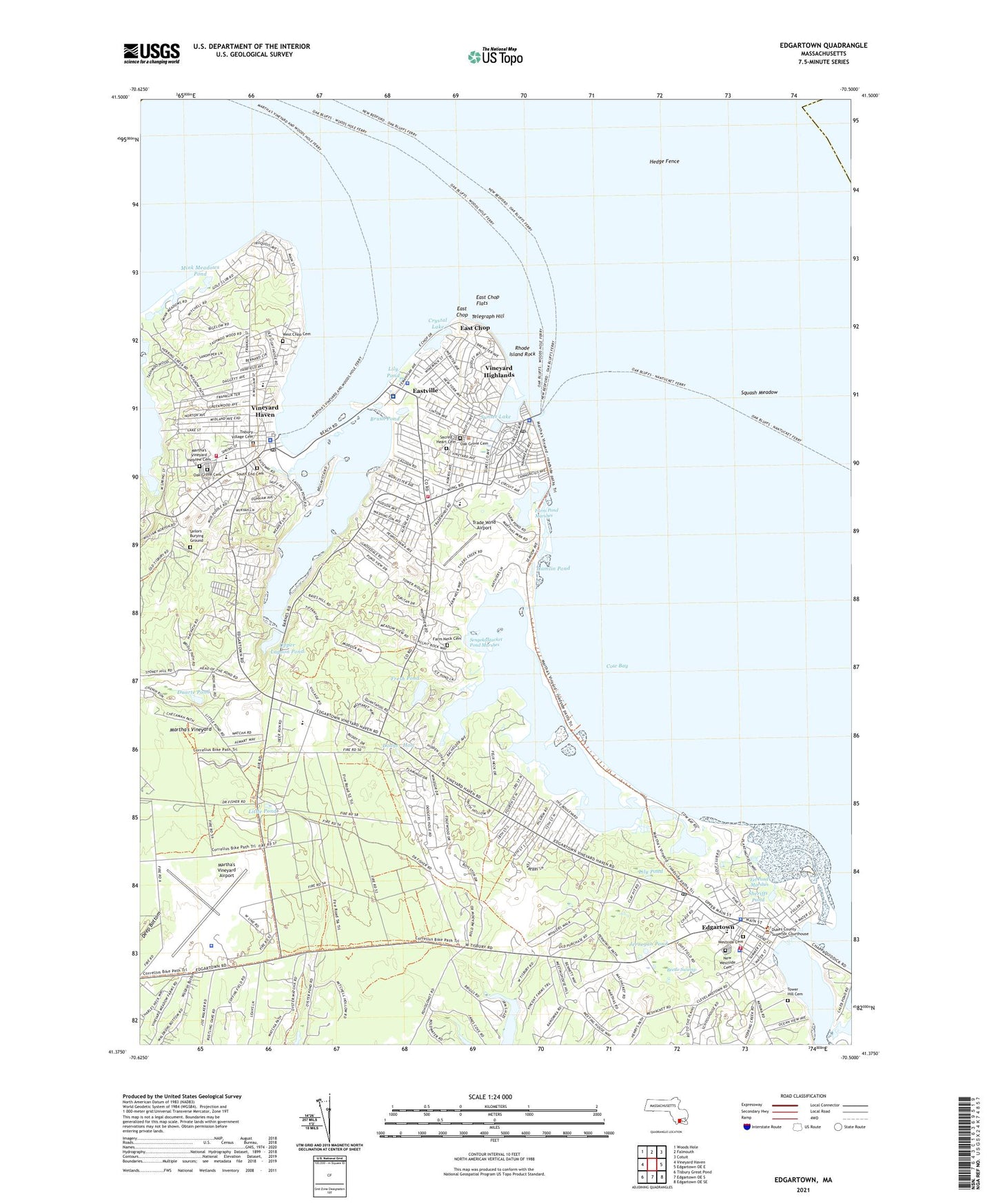
2024 topographic map quadrangle Edgartown in the state of Massachusetts. Scale: 1:24000. Based on the newly updated USGS 7.5' US Topo map series, this map is in the following counties: Dukes, Barnstable. The map contains contour data, water features, and other items you are used to seeing on USGS maps, but also has updated roads and other features. This is the next generation of topographic maps. Printed on high-quality waterproof paper with UV fade-resistant inks.
Quads adjacent to this one:
West: Vineyard Haven
Northwest: Woods Hole
North: Falmouth
Northeast: Cotuit
East: Edgartown OE E
Southeast: Edgartown OE SE
South: Edgartown OE S
Southwest: Tisbury Great Pond
This map covers the same area as the classic USGS quad with code o41070c4.
Contains the following named places: Alleghany Rock, Beetle Swamp, Bend-in-the-Road Beach, Big Rock, Bran Point, Brown Point, Brush Island, Brush Pond, Caleb Pond Marshes, Caroline Tuthill Preserve, Cedar Neck, Chappaquiddick, Chappaquiddick Point, Clevelandtown, Cottage City, Cottage Museum, County of Dukes County Sheriff, Cow Bay, Crystal Lake, Dale Huntington Library, Dividend Point, Doctor Daniel Fisher House Museum, Dodger Hole, Douglas Rock, Duarte Pond, Dukes County Courthouse, Dukes County Historical Museum, Dukes County Historical Society Building, Dukes County Law Library, Dukes County Sheriff's Office, East Chop, East Chop Beach Club, East Chop Flats, East Chop Light, Eastville, Eastville Beach, Edgartown, Edgartown Beach, Edgartown Census Designated Place, Edgartown Elementary School, Edgartown Fire Department Station 1 Headquarters, Edgartown Golf Club, Edgartown Harbor Light, Edgartown Light, Edgartown Memorial Park, Edgartown Police Department, Edgartown Post Office, Edgartown Public Library, Edgartown Town Hall, Edgartown United Methodist Church, Edgartown Village Historic District, Edgartown Visitors Center, Edgartown Yacht Club, Eel Pond, Eel Pond Marshes, Farm Neck Cemetery, Farm Pond, Farm Pond Marshes, Federated Church, Felix Neck, Felix Neck Wildlife Sanctuary, Ferry Boat Island, Flat Point, Foster Maritime Gallery, Fresh Pond, Fuller Street Beach, Gingerbread Cottages and Tabernacle, Gravel Island, Hamlin Pond, Hansel and Gretel Doll Museum, Harthaven, Harts Harbor, Hartsville, Haystack Point, Hedge Fence, Hines Point, Husselton Head, Hy-Line Dock, Island Queen Dock, Jernegan Pond, Jerneganville, Joseph Sylvia State Beach Park, Katherine Cornell Theater, Lagoon Heights, Lagoon Pond, Lighthouse Beach, Lily Pond, Little Beach, Little Pond, Lone Rock, Lovers Rock, Majors Cove, Martha's Vineyard, Martha's Vineyard Aero Light, Martha's Vineyard Airport, Marthas Vineyard Campground, Marthas Vineyard Chamber of Commerce, Martha's Vineyard Country Club, Martha's Vineyard Hebrew Cemetery, Martha's Vineyard Hospital, Martha's Vineyard Regional High School, Marthas Vineyard Shipyard, Martha's Vineyard State Forest, Massachusetts State Lobster Hatchery, Massachusetts State Police Oak Bluffs Station D5, Meadow Rock, Memorial Wharf, Middle Flats, Middle Ground, Mill Hill, Mink Meadows Golf Course, Mink Meadows Pond, Nashamois Neck, New Westside Cemetery, North Head, Nunnepog, Oak Bluffs, Oak Bluffs Census Designated Place, Oak Bluffs Elementary School, Oak Bluffs Ferry Slip Light, Oak Bluffs Fire Department, Oak Bluffs Harbor, Oak Bluffs North Breakwater Light, Oak Bluffs Police Department, Oak Bluffs Post Office, Oak Bluffs Public Library, Oak Bluffs Town Beach, Oak Bluffs Town Hall, Oak Grove Cemetery, Ocean Heights, Oklahoma Heights, Old Schoolhouse Museum and Liberty Pole, Old Westside Cemetery, Old Whaling Church, On Time Ferry, Our Lady Star of the Sea Roman Catholic Church, Owen Park, Owen Park Beach, Rhode Island Rock, Robbins Rock, Sacred Heart Cemetery, Sacred Heart Church, Sailors Burying Ground, Saint Andrews Episcopal Church, Saint Augustines Church, Saint Elizabeth Church, Sarson Island, Schamonchi Dock, Seamans Bethel, Sengekontacket Pond, Sengekontacket Pond Marshes, Sengekontakit, Sheriffs Meadow, Sheriffs Pond, Snows Point, South End Cemetery, Squash Meadow, Steamship Authority Wharf, Sunset Lake, Tashmoo Hill, Tashmoo Overlook, Telegraph Hill, Thomas Cooke House Museum, Tisbury Elementary School, Tisbury Elementary School Library, Tisbury Fire Department, Tisbury Museum, Tisbury Police Department, Tisbury School, Tisbury Town Beach, Tisbury Town Hall, Tisbury Village Cemetery, Tower Hill Cemetery, Town of Oak Bluffs, Town of Tisbury, Trade Wind Airport, Trapps Pond, Trinity Episcopal Church, Trinity Park, Trinity Park Methodist Church, Unitarian Universalist Society, Upper Lagoon Pond, Veira Park, Veterans Memorial Park, Vincent House Museum, Vineyard Haven, Vineyard Haven Breakwater Light, Vineyard Haven Census Designated Place, Vineyard Haven Ferry Slip Light, Vineyard Haven Harbor, Vineyard Haven Post Office, Vineyard Haven Public Library, Vineyard Haven Yacht Club, Vineyard Highlands, Waban Park, Weeks Neck, West Chop, West Chop Cemetery, West Chop Light, West Chop Woods, William Street Historic District, Wintucket Cove, WMVY-FM (Tisbury), Wood Island, ZIP Codes: 02539, 02557, 02568