MyTopo
Harwich Massachusetts US Topo Map
Couldn't load pickup availability
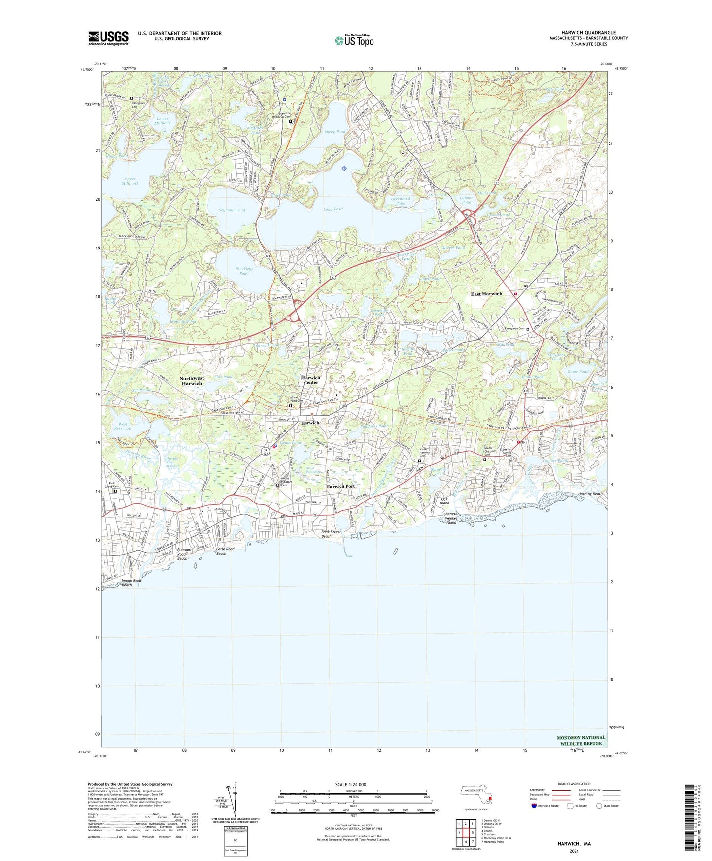
2021 topographic map quadrangle Harwich in the state of Massachusetts. Scale: 1:24000. Based on the newly updated USGS 7.5' US Topo map series, this map is in the following counties: Barnstable. The map contains contour data, water features, and other items you are used to seeing on USGS maps, but also has updated roads and other features. This is the next generation of topographic maps. Printed on high-quality waterproof paper with UV fade-resistant inks.
Quads adjacent to this one:
West: Dennis
Northwest: Dennis OE N
North: Orleans OE W
Northeast: Orleans
East: Chatham
Southeast: Monomoy Point
South: Monomoy Point OE W
Contains the following named places: 333 Main Street Shopping Center, Allen Harbor, Allens Harbor Breakwater Light, Andrews Pond, Andrews River, Andrews River East Jetty Light, Aunt Edies Pond, Bank Street Beach, Bay Path Regional Vocational Technical High School Media Center, Bells Neck, Black Pond, Brewster Memorial Cemetery, Brewster Police Department, Brooks Library, Bucks Creek, Bucks Creek Marshes, Bucks Pond, Cahoon Pond, Canoe Pond, Cape Cod, Cape Cod Regional Technical High School, Cape Cod Regional Technical High School Library, Chatham Fire and Rescue Department Station 2, Cockle Cove, Cockle Cove Creek, Congregational Church, Cornelius Pond, Dillingham Cemetery, Doanes Creek, Duane Pond, Earle Road Beach, East Harwich, East Harwich Airport, East Harwich Census Designated Place, Ebenezar Weekes Island, Eldredge Family Cemetery, Evergreen Cemetery, Flax Pond, Forest Beach, Girl Scout Camp, Goose Pond, Grass Pond, Grass Pond Bog, Grassy Pond, Greenland Pond, Griffiths Pond, Harwich, Harwich Center Census Designated Place, Harwich Elementary School Library Media Center, Harwich Fire Department Station 1 Headquarters, Harwich Fire Department Station 2, Harwich Police Department, Harwich Port, Harwich Port Census Designated Place, Harwich Port Post Office, Harwich Post Office, Harwich Station, Hawksnest Pond, Hawksnest State Park, Herring River, Herring River Marshes, Hinckleys Pond, Inman Road Beach, Island Pond, Island Pond Cemetery, Josephs Pond, Kellys Wharf, Kolb Rock, Lewis Pond, Long Pond, Long Pond Seaplane Base, Lower Mill Pond Dam, Lower Millpond, Mill Creek, Mill Pond, Ministers Pond, Monomoy Regional High School, Mount Pleasant Cemetery, Mud Pond, North Harwich, Northwest Harwich Census Designated Place, Oak Island, Olivers Pond, Paddocks Pond, Pine Grove Cemetery, Pine Grove Seminary, Pleasant Lake, Pleasant Lake Station, Pleasant Road Beach, Rafe Pond, Red River, Red River Beach, Robbins Pond, Round Pond, Ryders Pond, Sand Pond, Saquatucket Harbor, Seymour Pond, Sheep Pond, Skinequit Pond, Smalls Pond, Smith Pond, South Brewster, South Chatham, South Chatham Cemetery, South Chatham Post Office, South Chatham Station, South Harwich, South Harwich Cemetery, South Harwich Post Office, Stony Brook Mill, Taylors Pond, The Church of Jesus Christ of Latter Day Saints, The Laurel School, Town of Brewster, Town of Harwich, Upper Millpond, Walkers Pond, WCCT-FM (Harwich), West Brewster, West Harwich, West Harwich Post Office, West Reservoir, WFCC-FM (Chatham), WFXR-FM (Harwich Port), Winslows Narrows, Wychmere Harbor, Wychmere Harbor Jetty Light, ZIP Codes: 02631, 02645, 02646, 02659, 02671