MyTopo
Salem Depot New Hampshire US Topo Map
Couldn't load pickup availability
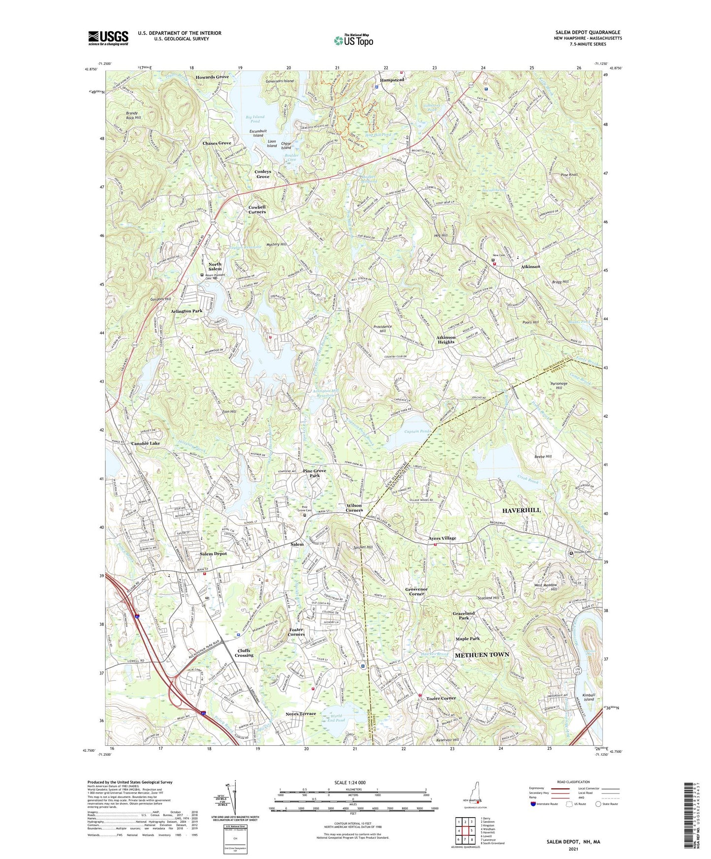
2024 topographic map quadrangle Salem Depot in the states of New Hampshire, Massachusetts. Scale: 1:24000. Based on the newly updated USGS 7.5' US Topo map series, this map is in the following counties: Rockingham, Essex. The map contains contour data, water features, and other items you are used to seeing on USGS maps, but also has updated roads and other features. This is the next generation of topographic maps. Printed on high-quality waterproof paper with UV fade-resistant inks.
Quads adjacent to this one:
West: Windham
Northwest: Derry
North: Sandown
Northeast: Kingston
East: Haverhill
Southeast: South Groveland
South: Lawrence
Southwest: Lowell
Contains the following named places: All Our Children's House Child Care Center, Ararat Armenian Congregational Church, Arlington Mill Reservoir, Arlington Mill Reservoir East Dike, Arlington Mill Reservoir West Dike, Arlington Park, Atkinson, Atkinson Academy, Atkinson Congregational Church, Atkinson Fire Department, Atkinson Heights, Atkinson Police Department, Atkinson Town Hall, Ayers Village, Ballard State Forest, Bare Meadow Brook, Beebe Hill, Big Island Pond, Big Island Pond Dam, Blunts Pond, Boulder Cove, Bragg Hill, Brandy Rock Hill, Canobie Lake, Canobie Lake Park, Canobie Lake Park Emergency Medical Services, Captain Pond, Captain Pond Brook, Chase Island, Chases Grove, Chopper One Heliport, Cluffs Crossing, Conleys Grove, Countryside Schoolhouse, Cowbell Corners, Create and Discover Learning Center, Creek Brook, Crystal Lake Dam, Crystal Lake Reservoir, Crystal Springs Golf Club, Digital New Salem Heliport, Doctor L F Soule School, Drew Brook, Escambuit Campground, Escumbuit Island, First Baptist Church, First Congregational Church of Salem, First Impressions Learning Center, Flatrock Brook, Foster Corners, Francis M Leahy School, Goddard Airport, Gordon Brown Heliport, Gordons Hill, Governors Island, Graceland Park, Greater Salem Chamber of Commerce, Grosvenor Corner, Hampstead, Hampstead Academy, Hampstead Central School, Hampstead Fire Rescue Central Station, Hampstead Hospital, Hampstead Police Department, Haverhill Fire Department Station 8, Hesser College Salem Campus, Hillside Cemetery, Hittytity Brook, Hodges Millpond, Hog Hill, Hog Hill Brook, Hog Hill Pond, Howards Grove, Howe School, Island Pond, Johnsons Pond, Kelley Library, Kimball Island, Kimball Public Library, Loon Island, Maple Park, Mary A Fisk Elementary School, Mary A Fisk Preschool, Mary Queen of Peace Church, Merrimack Valley Golf Club, Methuen Fire Department Station 6, Millville, Millville Lake, Millville Reservoir Dam, Mitchels Falls, Mount Pleasant Cemetery, Mystery Hill, Nettles Mall, New Cemetery, New England Gliderport, North Salem, North Salem Elementary School, North Salem Post Office, North Salem Preschool, North Salem United Methodist Church, Northeast Rehabilitation Hospital, Northeastern Gliderport, Noyes Terrace, Parsonage Hill, Pine Grove Cemetery, Pine Grove Park, Pine Knoll, Pleasant Street United Methodist Church, Poors Hill, Porcupine Brook, Providence Hill, Providence Hill Brook, Reservoir Hill, Robert Frost School, Rockingham Mall Shopping Center, Rockingham Park, Rockingham Park Ambulance, Rockwell School, Saint Davids Episcopal Church, Saint Joseph Regional School, Saint Josephs Parish Church, Salem, Salem Boys and Girls Club Preschool, Salem Christian School, Salem Depot, Salem Depot Post Office, Salem Fire Department Station 1 Headquarters, Salem High School, Salem Plaza Shopping Center, Salem Police Department, Salem Post Office, Salem Town Hall, Sawmill Swamp, Scotland Hill, Shadow Lake, Shadow Lake Dam, Sisters Pond, Southern New Hampshire University at Salem, Spicket Hill, Taylor Brook, Taylor Dam, Taylors Reservoir, The Mall at Rockingham Park Shopping Center, Town of Atkinson, Town of Salem, Town of Salem Fire Department Station 2 North Salem, Town of Salem Fire Department Station 3 South Salem, Tozier Corner, Walter F Haigh School, West Meadow Hill, West Parish, Wheeler Dam, Wickson Heliport, Widow Harris Brook, William E Lancaster School, William T Barron Elementary School, Wilson Corners, Wonder Year Learning Center, Woodbury School, World End Pond, Zion Hill, ZIP Codes: 01832, 03079, 03811