MyTopo
Haverhill Massachusetts US Topo Map
Couldn't load pickup availability
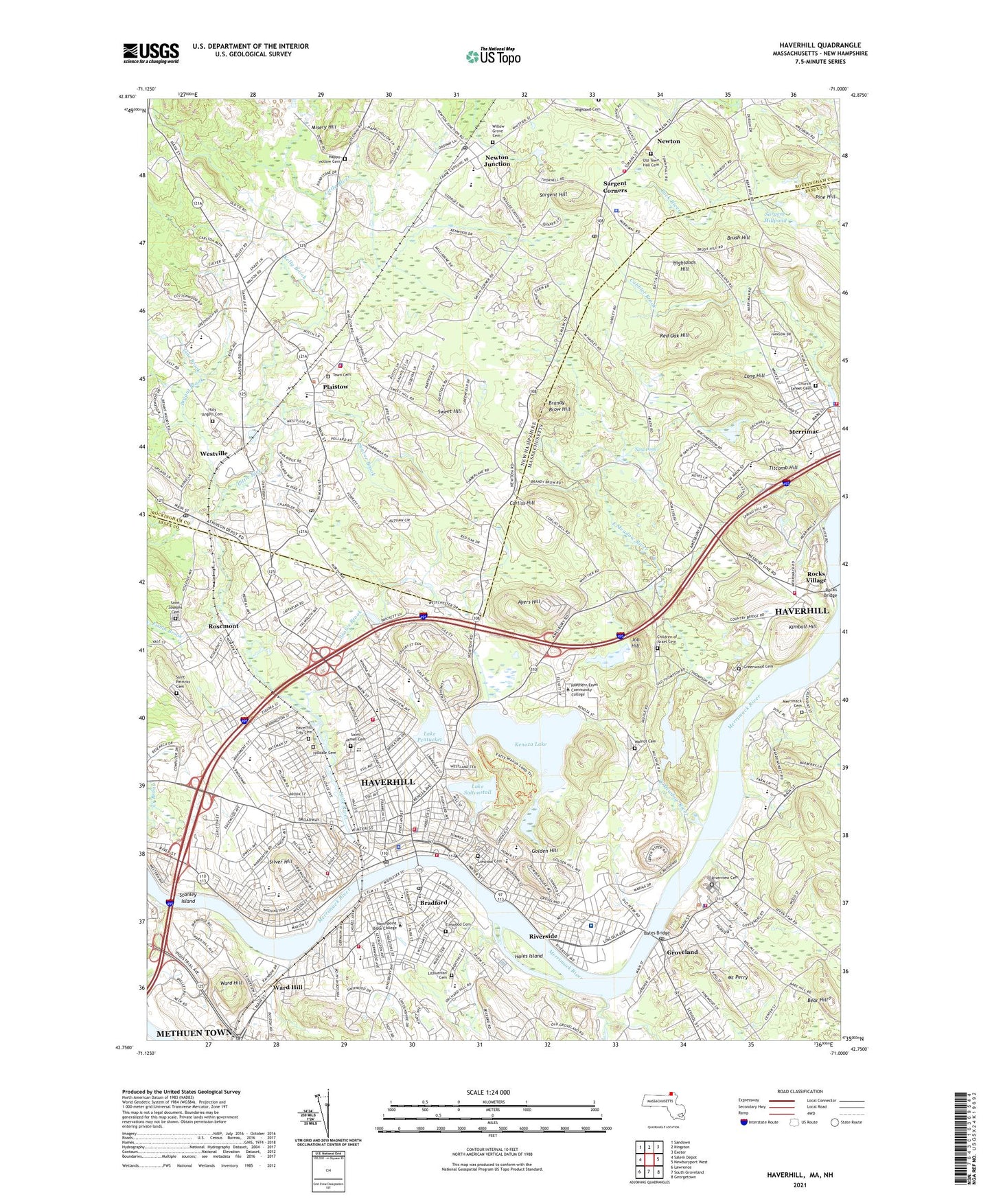
2024 topographic map quadrangle Haverhill in the states of Massachusetts, New Hampshire. Scale: 1:24000. Based on the newly updated USGS 7.5' US Topo map series, this map is in the following counties: Essex, Rockingham. The map contains contour data, water features, and other items you are used to seeing on USGS maps, but also has updated roads and other features. This is the next generation of topographic maps. Printed on high-quality waterproof paper with UV fade-resistant inks.
Quads adjacent to this one:
West: Salem Depot
Northwest: Sandown
North: Kingston
Northeast: Exeter
East: Newburyport West
Southeast: Georgetown
South: South Groveland
Southwest: Lawrence
Contains the following named places: Alliance Church, Atkinson Depot, Atkinson Post Office, Ayers Hill, Bartlett School, Bates Bridge, Bear Hill, Bentley Library, Bradford, Bradford College, Bradford Common Historic District, Bradford Country Club, Bradford Post Office, Brandy Brow Hill, Brush Hill, Bryant Brook, Burnham Elementary School, Caleb Dustin Hunking School, Camp Brook, Cedar Brook Plaza Shopping Center, Central Plaza, Central Plaza Shopping Center, Children of Israel Cemetery, Children of Israel Church, Church of Jesus Christ United Church, Church Street Cemetery, City of Haverhill, Cogswell School, Consentino School, Corliss Hill, Corner Stone Christian Church, Crane Crossing, Crowell School, Doctor Frederick N Sweetsir School, Doctor Paul Nettle School, East Haverhill Post Office, East Haverhill School, East Meadow River, East Parrish Church, Elmwood Cemetery, First Baptist Church, First Christian Church, First Church of Christ, First Congregational Church, First Presbyterian Church, Fishin Brook, Foote Brook, Fox School, Free Will Baptist Meeting House, Frye Pond, Gale Library, Glynn Memorial Hospital, Golden Hill, Golden Hill School, Golden Hill School Library Library, Grace Church, Greenleaf School, Greenwood Cemetery, Groveland, Groveland Congregational Church, Groveland Fire Department Station 1 Headquarters, Groveland Police Department, Groveland Post Office, Groveland School, Hale Hospital, Hales Island, Happy Hollow Cemetery, Harbor-Commonworks School, Haverhill, Haverhill - Riverside Airport, Haverhill Alternative School, Haverhill City Cemetery, Haverhill City Hall, Haverhill Community Church, Haverhill Country Club, Haverhill Fire Department Fire Chief, Haverhill Fire Department Station 1, Haverhill Fire Department Station 2, Haverhill Fire Department Station 3 Headquarters, Haverhill Fire Department Station 4, Haverhill Fire Department Station 9, Haverhill High School, Haverhill Municipal Hospital Medical Library, Haverhill Plaza Shopping Center, Haverhill Police Department, Haverhill Post Office, Haverhill Public Library, Haverhill Stadium, Haverhill Station, Helen R Donaghue School, Highland Cemetery, Highlands, Highlands Hill, Highlandville, Hill View Montessori Charter School of Haverhill, Hilldale Cemetery, Holy Angels Cemetery, Holy Angels Preschool and Kindergarten, Holy Apostle Peter and Paul Church, Holy Family Hospital - Haverhill, Hunking School, Indian Mound Ski Area, Intervale Factory, Job Hill, John G Whittier School, Johnson Creek, Kelly Brook, Kenoza Ave Pond Dam, Kenoza Lake, Kenoza Lake Dam, Kimball Hill, Lake Pentucket, Lake Saltonstall, Lake Saltonstall Outlet Dam, Line Brook, Linwood Cemetery, Lithuanian Cemetery, Little River, Little River Reservoir, Long Hill, Mary Mother of the Church Roman Catholic Church, Memorial School, Merrimac, Merrimac Fire Department, Merrimac Police Department, Merrimac Post Office, Merrimack Cemetery, Merrimack School, Milburn Alternative-Haverhill School, Millvale Reservoir, Millvale Reservoir Dam, Misery Hill, Moody School, Mount Perry, Neal Pond, Newton, Newton Fire Department, Newton Junction, Newton Junction Post Office, Newton Learning Center, Newton Police Department, Newton Post Office, Northern Essex Community College, Old Town Hall Cemetery, Passaqua Playground, Peabody School, Pentucket Lake Elementary School, Pentucket Regional High School, Pentucket Regional Middle School, Pine Hill, Pines Speedway, Plaistow, Plaistow Fire Department, Plaistow Police Department, Plaistow Post Office, Plaistow Public Library, Plaistow Town Hall, Pollard Elementary School, Pollard Preschool, R L Wood School, Rainbow Preschool and Kindergarten, Red Oak Hill, Riveride Park, Riverside, Riverview Cemetery, Rocks Village, Rosemont, Sacred Hearts Elementary School, Saint Christophers Church, Saint James Cemetery, Saint James School, Saint Joseph Elementary School, Saint Josephs Cemetery, Saint Patricks Cemetery, Sanborn Regional Middle School, Sargent Corners, Sargent Hill, Sargent Millpond, Seaver Brook, Silver Hill, Snows Brook, Stanley Island, Stephens Dam, Sweet Hill, Sweet Hill Kindergarten School, TEACH School, Teddy Bear Nursery School and Day Care, The Whittier Pavilion, Thomas Hoyt Memorial Library, Tilton School, Tiltons Tower, Timberlane Baptist Church, Timberlane Regional High School, Timberlane Regional Middle School, Titcomb Hill, Town Cemetery, Town of Groveland, Town of Merrimac, Town of Newton, Town of Plaistow, Walnut Cemetery, Walnut Square School, Ward Hill, West Meadow Brook, Westville, WHAV-AM (Haverhill), Whittier Regional Vocational High School, Willow Grove Cemetery, Winnekenni Park, WLYT-FM (Haverhill), ZIP Codes: 01830, 01834, 01835, 01860, 03858, 03865