MyTopo
Lowell Massachusetts US Topo Map
Couldn't load pickup availability
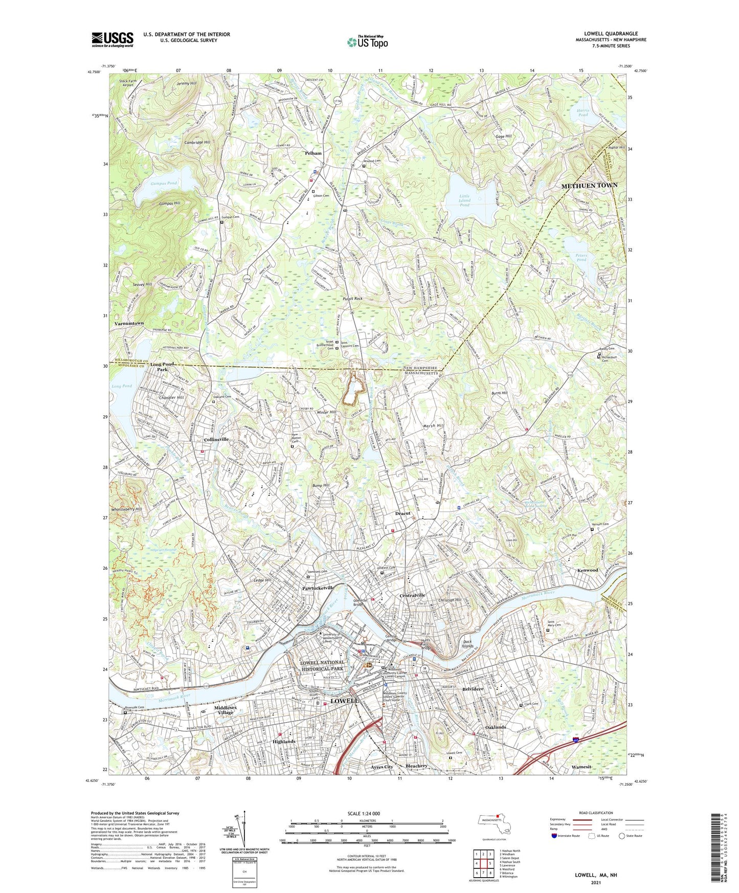
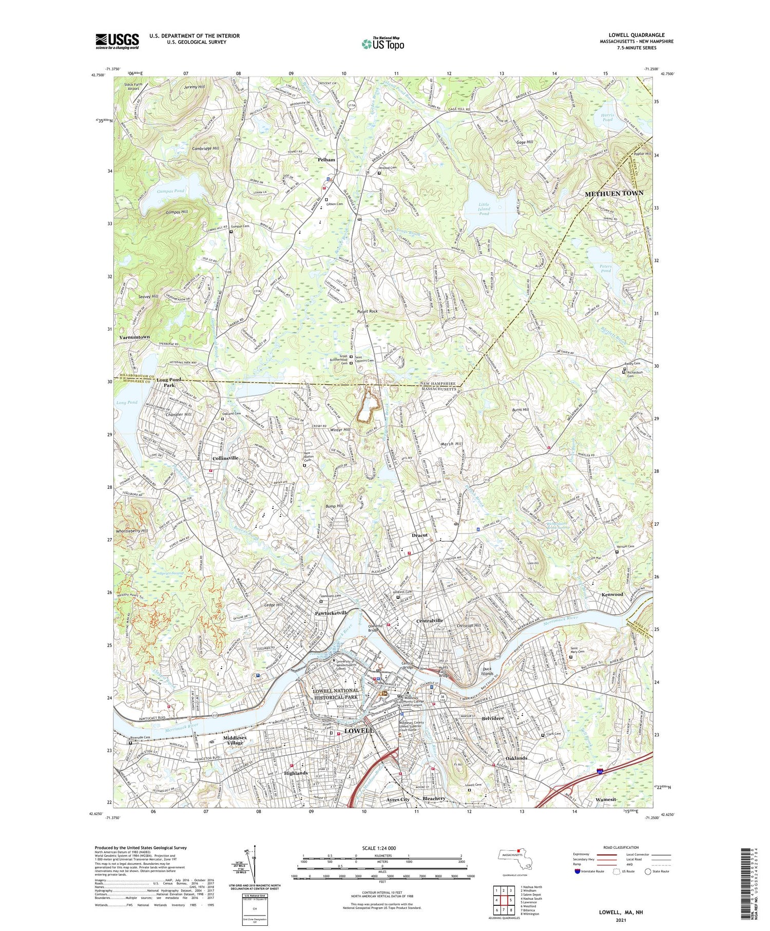
2021 topographic map quadrangle Lowell in the states of Massachusetts, New Hampshire. Scale: 1:24000. Based on the newly updated USGS 7.5' US Topo map series, this map is in the following counties: Middlesex, Hillsborough, Essex, Rockingham. The map contains contour data, water features, and other items you are used to seeing on USGS maps, but also has updated roads and other features. This is the next generation of topographic maps. Printed on high-quality waterproof paper with UV fade-resistant inks.
Quads adjacent to this one:
West: Nashua South
Northwest: Nashua North
North: Windham
Northeast: Salem Depot
East: Lawrence
Southeast: Wilmington
South: Billerica
Southwest: Westford
Contains the following named places: Abraham Lincoln School, Alumni Field, Ames Street School, Appleton Mill, Atwood Cemetery, Ayres City, Bailey Cemetery, Bartlett Junior High School, Beaver Brook, Beaver Brook Reservoir, Belvidere, Benjamin F. Butler Middle School, Black Brook, Bleachery, Boarding House Park, Boott Cotton Mills, Boott Mills, Boston and Lowell Railroad Memorial, Bump Hill, Burns Hill, Cambridge Hill, Camp Alexander, Cardinal O'Connell School, Cedar Pond, Central Bridge, Centralville, Chandler Hill, Charles W Morey School, Charlotte M Murkland Elementary School, Christian Hill, City Hall Historic District, City of Lowell, Clark Cemetery, Claypit Brook, Colburn School, Collinsville, Collinsville Dam, Concord River, Concord River Reservoir, Demonstration School, Doctor An Wang School, Doctor Gertrude Bailey School, Double Brook, Dracut, Dracut Junior High School, Dracut Senior High School, Duck Islands, E N Rogers School, Eastern Canal, Eastern Canal Park, Eastgate Plaza Shopping Center, Eliot School, Flaggy Meadows Playground, Fort Hill, Fort Hill Park, Francis Gate, Franco American Elementary School, Gage Hill, Gage Park, George H Englesby Junior High School, Gibson Cemetery, Golden Brook, Goodhue School, Grace Bible Church Christian School, Greenhalge School, Greenmount Avenue School, Guard Locks, Gumpas Cemetery, Gumpas Hill, Gumpas Pond, Gumpas Pond Brook, Gumpas Pond Dam, Hadley Field, Hamblett Cemetery, Hamilton Canal, Hamilton Mill, Harris Pond, Hellenic American School, Henry L Robinson School, Highland Playground, Highlands, Hildreth Cemetery, Holy Trinity Elementary School, Hovey Square, Hugh J Molloy School, Hunts Falls Bridge, Immaculate Conception School, Island Pond Brook, Israel Brotherhood Cemetery, James Sullivan School, Jeremy Hill, Jeremy Hill Forest, Joseph A Campbell Elementary School, Keith Academy, Keith Hall High School, Kenwood, Kerouac Commemorative, Kittredge Park, Laura Lee Alternative School, Lawrence Mill, Lawrence Wasteway, Ledge Hill, Little Island Pond, Long Pond, Long Pond Park, Longmeadow Golf Club, Longmeadow Golf Course, Loon Hill, Lowell, Lowell Cemetery, Lowell General Hospital, Lowell General Hospital - Saints Campus, Lowell High School, Lowell Locks, Lowell National Historical Park, Lowell Reservoir, Lowell Reservoir Dam, Lowell Station, Lowell-Dracut State Forest, Lower Locks, Lower Pawtucket Canal Dam, Lower Pawtucket Canal Reservoir, Lucy Larcom Park, Marbles Brook, Market Mills, Marsh Hill, Massachusetts Mill, Massachusetts Wasteway, McPherson Playground, Memorial Stadium, Merrimack Canal, Merrimack River Reservoir, Merrimack Wasteway, Merrimack-Middle Street Historic District, Middlesex Canal, Middlesex County Training School, Middlesex Dam, Middlesex Plaza Shopping Center, Middlesex Village, Moody Elementary School, Mount Pleasant Golf Club, New Boston Cemetery, Nickel Mine Brook, Northern Canal, Northern Canal Head Gates Dam, Oakland Cemetery, Oaklands, Old Guard Locks Dam, Ouelette Bridge, Parker Avenue School, Pawtucket Canal, Pawtucket Canal Reservoir, Pawtucket Dam, Pawtucket Falls, Pawtucket School, Pawtucketville, Pawtucketville Memorial School, Pawtucketville Technological Institute, Pelham, Peppermint Brook, Peter W Reilly School, Peters Pond, Peters Pond Dam, Pine Street School, Pine Valley Golf Club, Pleasant Street Dam, Pond Street School, Poplar Hill, Potash Brook, Princeton Village, Pulpit Rock, Richardson Cemetery, Richardsons Brook Swamp, River Meadow Brook, Riverside Cemetery, Rogers Hall School, Rogerson School, Sacred Heart School, Saint Casimirs Cemetery, Saint Jeanne D'Arc School, Saint Johns Hospital, Saint Josephs Boys School, Saint Josephs Hospital, Saint Josephs School, Saint Louis Field, Saint Louis School, Saint Margarets School, Saint Mary Cemetery, Saint Michael Elementary School, Saint Patricks School, Saint Peters School, School Street Cemetery, Seavey Hill, Shedd Park, South Common Historic District, South Common Park, Spruce Swamp, Stadium Plaza Shopping Center, State Teachers College, Steck Farm Airport, Stony Brook, Suffolk Mill Turbine Exhibit, Sunrise Shopping Center, Thereses School, Tonys Brook, Town of Dracut, Town of Pelham, Trout Brook, Trull Brook Golf Club, Tull Brook, Tyler Park, Tyler Park Historic District, Upper Pawtucket Canal Dam, Upper Pawtucket Canal Reservoir, Varnum Cemetery, Varnum School, Varnumtown, Wamesit, Wamesit Canal-Whipple Mill Industrial Complex, Wamesit Power Company Dam, Wash Park, Washington Park, Washington Square Historic District, WCAP-AM (Lowell), Western Canal, Whortleberry Hill, Winter Hill, WJUL-FM (Lowell), WLLH-AM (Lowell), ZIP Codes: 01826, 01850, 01851, 01852, 01854, 03076