MyTopo
Nashua South New Hampshire US Topo Map
Couldn't load pickup availability
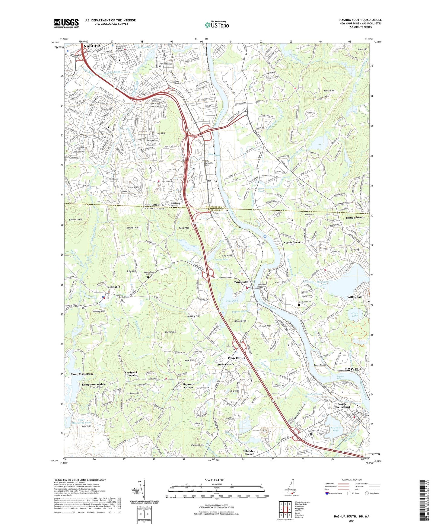
2024 topographic map quadrangle Nashua South in the states of Massachusetts, New Hampshire. Scale: 1:24000. Based on the newly updated USGS 7.5' US Topo map series, this map is in the following counties: Hillsborough, Middlesex. The map contains contour data, water features, and other items you are used to seeing on USGS maps, but also has updated roads and other features. This is the next generation of topographic maps. Printed on high-quality waterproof paper with UV fade-resistant inks.
Quads adjacent to this one:
West: Pepperell
Northwest: South Merrimack
North: Nashua North
Northeast: Windham
East: Lowell
Southeast: Billerica
South: Westford
Southwest: Ayer
Contains the following named places: Abrams Hill, Academy of Notre Dame, Academy of Notre Dame High School, Althea Lake, American Medical Response, Ayers Pond, Ayers Pond Dam, Bear Hill, Bethel Baptist Church of Hudson, Bethel Christian School, Bicentennial Elementary School, Bishop Guertin High School, Black Brook, Boston University Metropolitan College Corporate Education Center Library, Boston University Tyngsborough Campus, Bridge Meadow Brook, C S S Heliport, Camp Immaculate Heart, Camp Kiwanis, Camp Massapoag, Central Cemetery, Chaney Hill, Chelmsford Fire Department Station 2, Church of Christ, City of Nashua, Cold Brook, Cold Springs Brook, Cow Pond Brook Dam, Curtis Hill, Deep Brook, Digital Heliport, Dunstable, Dunstable Congregational Church, Dunstable Fire Department, Dunstable Free Public Library, Dunstable Police Department, Dunstable Post Office, Dunstable Town Hall, East Groton, Evergreen Cemetery, Fairgrounds Elementary School, Fairgrounds Middle School, Fairview Cemetery, Federal Aviation Administration Air Traffic Control Center, Fields Grove, Flatrock Hill, Fletchers Pond, Fletchers Pond Dam, Flint Cemetery, Flint Pond, Flints Corner, Flushing Hill, Forest Hill, Fox Ledge, Frederick Corner, Fun World, Gilboa Hill, Gould Cemetery, Greater Lowell Technical High School, Greater Lowell Technical High School Library, Green Meadow Golf Club, Hale Brook, Harris Brook, Hassells Brook, Hauk Brook, Hayward Corner, Heritage Baptist Church, Hudson New Hampshire Fire Department Station 4, Hudson Post Office, Immaculate Conception Roman Catholic Church, Immaculate Heart Camp, Joint Grass Brook, Kendall Hill, Kiwanis Camp, Labine Park, Larsons Seaplane Base, Lawrence Brook, Lighthouse School, Limit Brook, Littlefield Library, Locust Hill, Locust Pond, Locust Pond Dam, Long Hill, Lower Massapoag Pond, Mascuppic Lake, Mascuppic Lake Dam, Massachusetts Baptist Temple, Massapoag Pond, Massapoag Pond Dam, Massapoag Ponds, Merrill Hill, Mount Royal, Musquash Brook, Nashua Country Club, Nashua Fire and Rescue Department Station 3, Nashua Fire and Rescue Station 2, Nashua Police Department, Nashua Presbyterian Church, Nashua South Post Office, New Searles Elementary School, Newfield Pond, Newfield Pond Dam, Norris Corner, Norris Road Elementary School, North Chelmsford, North Chelmsford Congregational Church, North Chelmsford Post Office, North School, Novitiate of the Oblates, Nutting Hill, Oak Hill, Old Dunstable Cemetery, Old Maids Brook, Perhams Four Corners, Pheasant Lane Mall Shopping Center, Pine Hill, Potash Hill, Presentation of Mary Academy, Proctor Park, Regina Library, Rita E Miller Elementary School, Rivier College, Roby Hill, Roby Park, Royal Ridge Mall Shopping Center, Sagamore Park, Saint Anthonys Friary, Saint Joseph Hospital and Trauma Center, Saint Josephs Novitiate, Saint Josephs Parish Roman Catholic Church, Saint Josephs School, Saint Mary Magdalen Church, Saint Phillips Greek Orthodox Church, Salmon Brook, Salmon Brook Main Street Pond, Salvation Army, Sandy Pond, Scarlet Brook, Scotty Hollow, Scribner Hill, Sherburne Cemetery, Spectacle Hill, Spit Brook, Sunset Heights Elementary School, Swains Pond, Swains Pond Dam, Swan Corner, Town Common, Town of Tyngsborough, Trinity Baptist Church, Tyngs Island, Tyngs Swamp, Tyngsboro, Tyngsboro Bridge, Tyngsboro Country Club, Tyngsboro Police Department, Tyngsboro Post Office, Tyngsboro Sportsmens Club, Tyngsborough Business Park, Tyngsborough Early Childhood Learning Center, Tyngsborough Elementary School, Tyngsborough Elementary School Library, Tyngsborough Evangelical Congregational Church, Tyngsborough Fire Department Station 3, Tyngsborough Fire Rescue Station 1, Tyngsborough Fire Rescue Station 2, Tyngsborough High School, Tyngsborough Junior-Senior High School, Tyngsborough Middle School, Tyngsborough Middle School Library, Tyngsborough Town Hall, Tynsborough Campground, Uesper Country Club, Union School, Upper Flint Pond Dam, Upper Massapoag Pond, Uptons Pond, Vesper Country Club, Westecch Industrial Park, Whidden Corner, WHOB-FM (Nashua), Wicassic Falls, Willow Springs Plaza Shopping Center, Willowdale, Winslow School, WMVU-AM (Nashua), WQNH-TV (Derry), WSMN-AM (Nashua), ZIP Codes: 01827, 01863, 01879, 03060