MyTopo
Westford Massachusetts US Topo Map
Couldn't load pickup availability
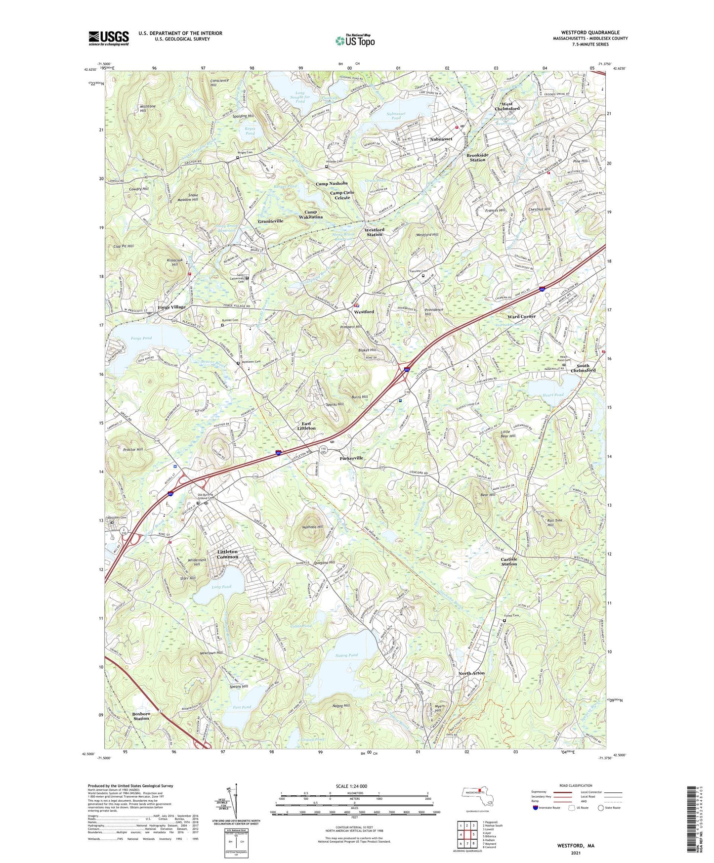
2024 topographic map quadrangle Westford in the state of Massachusetts. Scale: 1:24000. Based on the newly updated USGS 7.5' US Topo map series, this map is in the following counties: Middlesex. The map contains contour data, water features, and other items you are used to seeing on USGS maps, but also has updated roads and other features. This is the next generation of topographic maps. Printed on high-quality waterproof paper with UV fade-resistant inks.
Quads adjacent to this one:
West: Ayer
Northwest: Pepperell
North: Nashua South
Northeast: Lowell
East: Billerica
Southeast: Concord
South: Maynard
Southwest: Hudson
Contains the following named places: Abbott Elementary School, Abundant Life Assembly Church, Acton Mall Shopping Center, American Legion Field, Bear Hill, Beaver Brook, Bellows Farm Mill Dam Number 1, Belvidere School, Bethel Christian Church, Blakes Hill, Blue Brook, Boutwell Brook, Boxboro Station, Brookside Station, Burges Pond, Burns Hill, Butter Brook, Byam School, Cameron School, Camp Cielo Celeste, Camp Nashoba, Camp Wakitatina, Camp Weetamo, Carlisle Station, Centre Village, Charles D Harrington School, Chelmsford Fire Department Station 3, Chelmsford Fire Department Station 5, Chelmsford High School, Chestnut Hill, Chinese Baptist Church, Clay Pit Hill, Cobbs Pond, Coldspring Brook, Colonel John Robinson School, Colonel Moses Parker School, Commodore Foods Company Dam, Community Gardens, Conscience Hill, Cowdry Hill, Crooked Springs Brook, Day Elementary School, Digital - King Street Heliport, Drew Farms, East Littleton, Fairview Cemetery, Fat Park, First Church Unitarian, First Parish Church, Flushing Pond, Flushing Pond Dam, Forest Cemetery, Forge Pond, Forge Village, Forge Village Post Office, Fort Pond, Frances Hill, Gilson Brook, Graniteville, Grass Pond, Grassy Pond, Grassy Pond Conservation Area, Heart Pond, Heart Pond Cemetery, Heart Pond Dam, Hill Orchard, Hillside Cemetery, Houghton Memorial Building, J V Fletcher Library, John A Crisafulli Elementary School, Keyes Brook, Keyes Pond, Kissacook Hill, Little Bear Hill, Little Junior-Senior High School, Littleton Common, Littleton Common Census Designated Place, Littleton Common Town Hall, Littleton Fire Department, Littleton First Baptist Church, Littleton High School, Littleton Middle School, Littleton Middle School Library, Littleton Police Department, Littleton Post Office, Long Pond, Long Pond Brook, Long Sought-for Pond, Mill Pond Dam, Millstone Hill, Murdoch Middle Public Charter School, Murray Printing Company Dam, Myers Hill, Nabnasset, Nabnasset Lake Country Club, Nabnasset Pond, Nabnasset Pond Dam, Nabnasset Post Office, Nabnasset School, Nagog Hill, Nagog Hill Conservation Area, Nagog Pond, Nagog Pond Dam, Nashoba Brook Reservoir, Nashoba Club, Nashoba Hill, Nashoba Learning Group, Nashoba Valley Shopping Center, Nashoba Valley Technical High School, New Town, Newtown Hill, Nonset Brook, North Acton, North Middle School, Old Burying Ground Cemetery, Parkerville, Pine Hill, Proctor Hill, Prospect Hill, Providence Hill, Putneys, Quagana Hill, Rail Tree Hill, Reed Brook, Reuben Hoar Library, Russell Street Elementary School, Russian Cemetery, Saint Catherine Cemetery, Saint Catherines Church, Saint Marks Church, Shaker Lane Elementary School, Shattuck Street School, Snake Meadow Brook, Snake Meadow Hill, South Chelmsford, Spalding Hill, Sparks Hill, Spaulding Brook, Speans Hill, Starr Hill, Stony Brook Dam, Stony Brook Reservoir, Stork Support Congregational Church, Tadmuck Brook, Tadmuck Swamp, The Church of Jesus Christ of Latter Day Saints, Town of Littleton, Town of Westford, V F W FIeld, Village of Nagog Woods, Walsh Field, Ward Corner, West Chelmsford, West Chemsford Junior School, Westford, Westford Academy, Westford Bible Church, Westford Depot Dam, Westford Fire Department Station 1 Headquarters, Westford Fire Department Station 3, Westford Fire Department Station 4, Westford Hill, Westford Police Department, Westford Post Office, Westford Regency Heliport, Westford Station, Westford Town Common, Westford United Methodist Church, Westlawn Cemetery, Wilderness Hill, Wright Cemetery, ZIP Codes: 01460, 01718, 01886