MyTopo
Marblehead North Massachusetts US Topo Map
Couldn't load pickup availability
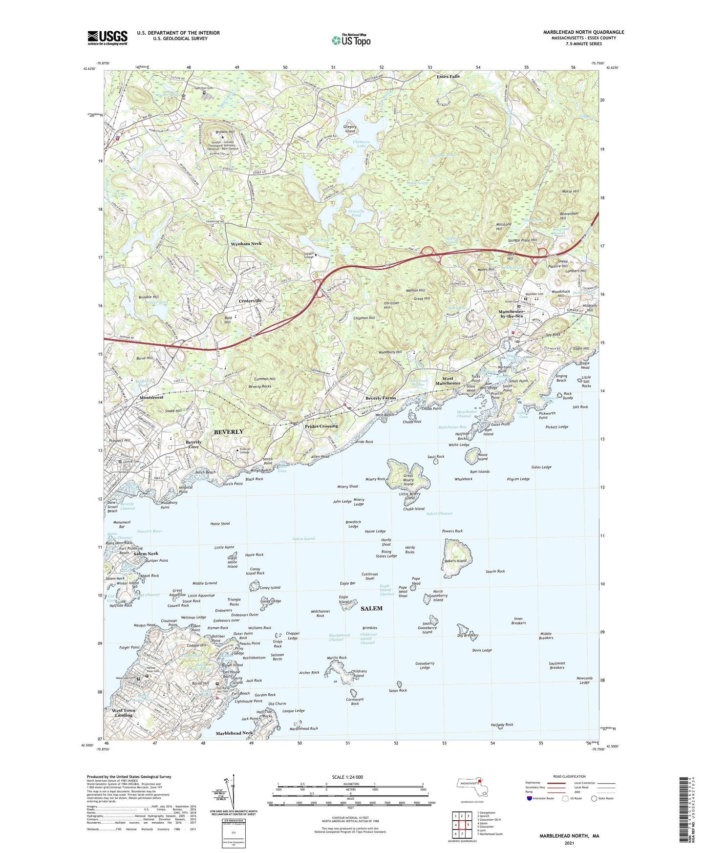
2021 topographic map quadrangle Marblehead North in the state of Massachusetts. Scale: 1:24000. Based on the newly updated USGS 7.5' US Topo map series, this map is in the following counties: Essex. The map contains contour data, water features, and other items you are used to seeing on USGS maps, but also has updated roads and other features. This is the next generation of topographic maps. Printed on high-quality waterproof paper with UV fade-resistant inks.
Quads adjacent to this one:
West: Salem
Northwest: Georgetown
North: Ipswich
Northeast: Gloucester OE N
East: Gloucester
South: Marblehead South
Southwest: Lynn
Contains the following named places: Abbot Rock, Allen Head, Archer Rock, Bakers Island, Bakers Island Light, Bald Hill, Ballarach Cove, Bayberry Swamp, Beaver Pond, Beaverdam Hill, Beaverdam Swamp, Beck Pond, Beverly Cove, Beverly Farms, Beverly Farms Station, Beverly Rocks, Black Cove, Black Joe Pond, Black Rock, Bobby Harris Pond, Boden Rocks, Boston Yacht Club, Bow Bell Ledge, Bowditch Ledge, Brimble Hill, Brimbles, Brown Island, Browns Hill, Burial Hill, Burnt Hill, Caswell Rock, Cat Brook, Cat Cove, Causeway Brook, Cedar Swamp, Centerville, Chandler-Hovey Park, Chappel Ledge, Chebacco Lake, Childrens Island, Chipman Hill, Christian Hill, Chubb Creek, Chubb Creek Marshes, Chubb Island, Chubb Islet, Chubb Point, City of Beverly, Cloutman Point, Coddon Hill, Common Hill, Coney Island, Coney Island Rock, Coney Ledge, Cooney Athletic Field, Corinthian Cove, Corinthian Yacht Club, Cormorant Rock, Coy Pond, Crocker Park, Curtis Point, Cutler Pond, Cutthroat Shoal, Dane Street Beach, Danvers River, Davis Ledge, Days Creek, Dix Park, Dolliber Cove, Dolliber Point, Dry Breakers, Eagle Bar, Eagle Head, Eagle Hill, Eagle Island, East Branch Cat Brook, Essex Country Club, Flag Pond, Fluen Point, Folger Point, Fort Beach, Fort Pickering Beach, Fort Pickering Lighthouse, Fort Sewall, Fountain Park, Gales Ledge, Gales Point, Gas House Basin, Gerry Island, Gerry Playground, Glass Head, Gooseberry Ledge, Gordon Rock, Gravelly Pond, Grays Rock, Great Aquavitae, Great Haste Island, Great Hill, Great Misery Island, Halftide Rock, Halfway Rock, Hamilton Historic District, Hamilton-Wenham Station, Hardy Rocks, Hardy Shoal, Harry Ball Field, Haste Rock, Hildreth Hill, Hobbs Pond, Hospital Point, Hospital Point Lighthouse, Hospital Point Range Light, House Island, House Ledge, Hurd Stadium, Inner Breakers, Iron Rail Girls Camp, Jack Hill, Jack Point, Jack Rock, John Ledge, Juniper Cove, Juniper Point, Kellehers Pond, Kettlebottom, Kimball Haskell Park, Lambert Hill, Lasque Ledge, Lighthouse Point, Little Aquavitae, Little Harbor, Little Haste, Little Misery Island, Little Salt Rocks, Lobster Cove, Longham Reservoir, Lynch Park, Mackerel Cove, Manchester Bay, Manchester Harbor, Manchester Station, Manchester-by-the-Sea, Maple Swamp, Marblehead, Marblehead Harbor, Marblehead Light, Marblehead Lighthouse, Marblehead Neck, Marblehead Rock, Martin Rock, Masconomo Park, Midchannel Rock, Middle Breakers, Middle Ground, Millets Swamp, Millstone Hill, Mingo Beach, Mini Mall, Misery Island Reservation, Misery Ledge, Misery Rock, Misery Shoal, Montserrat, Montserrat Station, Monument Bar, Morse Hill, Moses Hill, Naugus Head, Newcomb Ledge, North Gooseberry Island, Nortons Point, Norwood Pond, Old Churm, Outer Point Rock, Patch Beach, Patton Park, Peachs Point, Pickworth Point, Pitman Rock, Plum Cove, Pope Head, Porter Rock, Powers Rock, Pride Rock, Prides Crossing, Prides Crossing Station, Proctor Cove, Proctor Point, Prospect Hill, Ram Island, Ram Islands, Rams Horn Rock, Redds Pond, Rising States Ledge, Rock Dundy, Round Pond, Salem Neck, Salem Sound, Salem Willows Park, Salt Rock, Satan Rock, Sauli Rock, Sawmill Brook, Searle Rock, Sellman Berth, Sheep Pasture Hill, Shingle Place Hill, Singing Beach, Small Point, Smith Point, Snake Hill, South Gooseberry Island, Spy Rock, Stone Rock, Town of Manchester-by-the-Sea, Tucks Point, Wenham Neck, West Beach, West Manchester, West Town Landing, Whaleback, White Ledge, Whittiers Cove, Williams Rock, Winter Island, Winter Island Maritime Park, Woodbury Hill, Woodbury Point, Woodchuck Hill, Wyman Hill, YMCA Camp, ZIP Codes: 01915, 01944, 01945, 01970