MyTopo
Orange Massachusetts US Topo Map
Couldn't load pickup availability
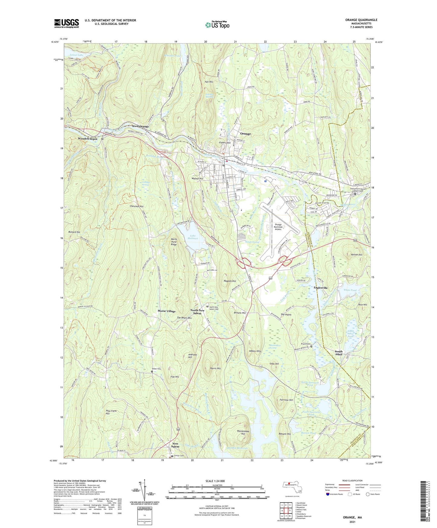
2024 topographic map quadrangle Orange in the state of Massachusetts. Scale: 1:24000. Based on the newly updated USGS 7.5' US Topo map series, this map is in the following counties: Franklin, Worcester. The map contains contour data, water features, and other items you are used to seeing on USGS maps, but also has updated roads and other features. This is the next generation of topographic maps. Printed on high-quality waterproof paper with UV fade-resistant inks.
Quads adjacent to this one:
West: Millers Falls
Northwest: Northfield
North: Mount Grace
Northeast: Royalston
East: Athol
Southeast: Petersham
South: Quabbin Reservoir
Southwest: Shutesbury
This map covers the same area as the classic USGS quad with code k42072e3.
Contains the following named places: Adams Hills, Andrews Hill, Bassett Hill, Bassett Pond, Bethany Evangelical Lutheran Church, Blackington Swamp, Bow Brook, Branch Cemetery, Browns Hill, Bullard Hill, Butterfield School, Camp Morgan Memorial, Center Cemetery, Central Congregational Church, Cheney Brook, Chestnut Hill, Cold Brook, Coolidge Brook, Coolidge Swamp, Darling Brook, Dexter Park School, Eaglesville, Eagleville, Ellinwood Brook, Fairview Hill, Fall Hill, Fall Hill Brook, Fall Hill Meadow, First Assembly of God Church, Fisher Hill School, Fishers Hill, Fisk Hill, Gays Hill, Giles Brook, Gulf Brook, Harris Hill, Haskins Dam, Kelton Hill, Kingdom Hall of Jehovahs Witnesses, Lake Mattawa, Lake Mattawa North Outlet Dam, Lake Mattawa South Outlet Dam, Lake Rohunta, Lake Rohunta Dam, Lakeridge Campground, Laurel Lake, Laurel Lake Dam, Magoon Hill, Manning Brook, McIver Brook, Mill Brook, Millers River Reservoir, Moosehorn Brook, Morse Village, Moss Brook, New Home Sewing Machine Company Dam, New Salem, New Salem Common Historic District, New Salem Post Office, New Salem Public Library, New Salem State Forest, New Salem Town Police Department, North Congregational Church, North New Salem, North Pond Brook Dam, North Pond Ridge, North Spectacle Pond, Orange, Orange Census Designated Place, Orange Center Historic District, Orange Fire Department Station 1 Headquarters, Orange Municipal Airport, Orange Police Department, Orange Post Office, Orange State Forest, Orange Town Hall, Orcutt Brook, Osgood Brook, Partridgeville, Poor Farm Hill, Ralph C Mahar Regional High School Library, Ralph C Mahar Regional School, Rattlesnake Hill, Red Brook, Rice Hill, Riceville Brook, Saint Marys Parish Church, Shingle Swamp, Shingle Swamp Brook, South Athol, South Athol Methodist Church, South Athol Pond, South Athol Pond Dam, South Spectacle Pond, Spriggy Brook, Swift River School, The Bears Den, The Plains, Thrower Brook, Town of Orange, Universalist Church, Walnut Hill, WCAT-AM (Orange-Athol), Wendell Depot, Wendell Depot Post Office, West Brook, West Orange, Wheeler Memorial Library, Wheelers Pond, Wheelers Pond Dam, Whetstone Brook, White Pond, White Pond Dam, Willow Brook, Woods Ice Pond, ZIP Code: 01364