MyTopo
Northfield Massachusetts US Topo Map
Couldn't load pickup availability
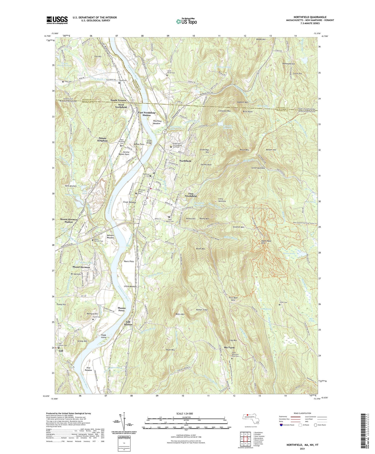
2024 topographic map quadrangle Northfield in the states of Massachusetts, New Hampshire, Vermont. Scale: 1:24000. Based on the newly updated USGS 7.5' US Topo map series, this map is in the following counties: Franklin, Cheshire, Windham. The map contains contour data, water features, and other items you are used to seeing on USGS maps, but also has updated roads and other features. This is the next generation of topographic maps. Printed on high-quality waterproof paper with UV fade-resistant inks.
Quads adjacent to this one:
West: Bernardston
Northwest: Brattleboro
North: Hinsdale
Northeast: West Swanzey
East: Mount Grace
Southeast: Orange
South: Millers Falls
Southwest: Greenfield
Contains the following named places: Ashuela Brook, Bailey Brook, Barnard Hill, Bass Swamp, Beers Mountain, Beers Plain, Bennett Brook, Bennett Meadow, Bent Pond, Birch Point, Black Swamp, Bolster Hill, Bottom Brook, Brush Mountain, Coller Cemetery, Community Church, Crag Mountain, Curtis Corner, Curtis Hill, Dry Brook, East Northfield, East Northfield Station, East Wait Brook, Erving State Forest, First Bald Hills, Fisher Brook, Fox Hill, Garnet Rock, Gill, Gill Center Cemetery, Gill Elementary School, Gill Station, Grandin Reservoir, Grassy Hill, Great Hemlock, Great Meadow, Great Swamp, Hammond Hill, Hells Kitchen, Hogback Mountain, Kidds Island, Lily Pond, Lily Pond Dam, Little Hemlock, Little Meadow, Louisiana Brook, Louisiana Mountain, Lovers Retreat Brook, Mallory Brook, Merriam Brook, Mill Brook, Millers Brook, Minot Brook, Moose Plain, Mount Hermon, Mount Hermon Station, Munns Ferry, Newton Brook, North Cemetery, Northfield, Northfield Baptist Church, Northfield Census Designated Place, Northfield Center School, Northfield Drive-In, Northfield Elementary School, Northfield Emergency Medical Service, Northfield Fire Department, Northfield Main Street Historic District, Northfield Police Department, Northfield Post Office, Northfield Reservoir, Northfield School Upper Reservoir Dam, Northfield State Forest, Northfield Townhall, Northfield-Mount Hermon School, Notch Mountain, Otter Run, Pauchaug Brook, Pauchaug Meadow, Pentecost Cemetery, Pine Meadow, Pioneer Valley Regional School, Pratt Hollow, Putnam Pond, Roaring Brook, Roman T Hill, Round Hill, Round Mountain, Saint Mary's Cemetery, Satans Kingdom, Sawyer Pond, Sawyer Pond Dam, Sawyer Ponds, Schell Bridge, Second Moose Plain, Shadow Lake, Sky Farm, South Cemetery, South Mountain, South Mountain Road Cemetery, South Parish Cemetery, South Vernon, Stevens Swamp, Stratton Mountain, Streeter Pond, Strobridge Hill, Stump Hill, Town of Northfield, Trinitarian Congregational Church, Tyler Cemetery, Unitarian Universalist Church, Upper Bald Hills, Vernon Hatchery Pond, Vernon Hatchery Pond Dam, Wanamaker Lake, Warwick State Forest, West Northfield, West Northfield Cemetery, West Wait Brook, WNMH-FM (Northfield), Woods Hill, ZIP Code: 01360